DeBunkem wrote:Look HERE, too. Note the chart on this page; at the time of the armistice in 1949, 8.54% of Israel was owned by either the Palestine Jewish Colonization Association, the Jewish National Fund, or Jewish individuals. Less than half that, 3.96%, was owned by Arab individuals. The rest was state land, which was transferred from the Arab government to the new Israeli government by UN mandate.
From the UN site: description of said Resolution 181, 1947:
UN Resolution 181 (II)
PART II
Boundaries 5/
A. THE ARAB STATE
The area of the Arab State in Western Galilee is bounded on the west by the Mediterranean and on the north by the frontier of the Lebanon from Ras en Naqura to a point north of Saliha. From there the boundary proceeds southwards, leaving the built-up area of Saliha in the Arab State, to join the southernmost point of this village. Thence it follows the western boundary line of the villages of `Alma, Rihaniya and Teitaba, thence following the northern boundary line of Meirun village to join the Acre-Safad sub-district boundary line. It follows this line to a point west of Es Sammu'i village and joins it again at the northernmost point of Farradiya. Thence it follows the sub-district boundary line to the Acre-Safad main road. From here it follows the western boundary of Kafr I'nan village until it reaches the Tiberias-Acre sub-district boundary line, passing to the west of the junction of the Acre-Safad and Lubiya-Kafr I'nan roads. From south-west corner of Kafr I'nan village the boundary line follows the western boundary of the Tiberias sub-district to a point close to the boundary line between the villages of Maghar and Eilabun, thence bulging out to the west to include as much of the eastern part of the plain of Battuf as is necessary for the reservoir proposed by the Jewish Agency for the irrigation of lands to the south and east.
The boundary rejoins the Tiberias sub-district boundary at a point on the Nazareth-Tiberias road south-east of the built-up area of Tur'an; thence it runs southwards, at first following the sub-district boundary and then passing between the Kadoorie Agricultural School and Mount Tabor, to a point due south at the base of Mount Tabor. From here it runs due west, parallel to the horizontal grid line 230, to the north-east corner of the village lands of Tel Adashim. It then runs to the north-west corner of these lands, whence it turns south and west so as to include in the Arab State the sources of the Nazareth water supply in Yafa village. On reaching Ginneiger it follows the eastern, northern and western boundaries of the lands of this village to their south-west corner, whence it proceeds in a straight line to a point on the Haifa-Afula railway on the boundary between the villages of Sarid and El Mujeidil. This is the point of intersection.
The south-western boundary of the area of the Arab State in Galilee takes a line from this point, passing northwards along the eastern boundaries of Sarid and Gevat to the north-eastern corner of Nahalal, proceeding thence across the land of Kefar ha Horesh to a central point on the southern boundary of the village of `Ilut, thence westwards along that village boundary to the eastern boundary of Beit Lahm, thence northwards and north-eastwards along its western boundary to the north-eastern corner of Waldheim and thence north-westwards across the village lands of Shafa 'Amr to the south-eastern corner of Ramat Yohanan'. From here it runs due north-north-east to a point on the Shafa 'Amr-Haifa road, west of its junction with the road to I'Billin. From there it proceeds north-east to a point on the southern boundary of I'Billin situated to the west of the I'Billin-Birwa road. Thence along that boundary to its westernmost point, whence it turns to the north, follows across the village land of Tamra to the north-westernmost corner and along the western boundary of Julis until it reaches the Acre-Safad road. It then runs westwards along the southern side of the Safad-Acre road to the Galilee-Haifa District boundary, from which point it follows that boundary to the sea.
The boundary of the hill country of Samaria and Judea starts on the Jordan River at the Wadi Malih south-east of Beisan and runs due west to meet the Beisan-Jericho road and then follows the western side of that road in a north-westerly direction to the junction of the boundaries of the sub-districts of Beisan, Nablus, and Jenin. From that point it follows the Nablus-Jenin sub-district boundary westwards for a distance of about three kilometres and then turns north-westwards, passing to the east of the built-up areas of the villages of Jalbun and Faqqu'a, to the boundary of the sub-districts of Jenin and Beisan at a point north-east of Nuris. Thence it proceeds first north-westwards to a point due north of the built-up area of Zir'in and then westwards to the Afula-Jenin railway, thence north-westwards along the district boundary line to the point of intersection on the Hejaz railway. From here the boundary runs south-westwards, including the built-up area and some of the land of the village of Kh.Lid in the Arab State to cross the Haifa-Jenin road at a point on the district boundary between Haifa and Samaria west of El Mansi. It follows this boundary to the southernmost point of the village of El Buteimat. From here it follows the northern and eastern boundaries of the village of Ar'ara, rejoining the Haifa-Samaria district boundary at Wadi'Ara, and thence proceeding south-south-westwards in an approximately straight line joining up with the western boundary of Qaqun to a point east of the railway line on the eastern boundary of Qaqun village. From here it runs along the railway line some distance to the east of it to a point just east of the Tulkarm railway station. Thence the boundary follows a line half-way between the railway and the Tulkarm-Qalqiliya-Jaljuliya and Ras el Ein road to a point just east of Ras el Ein station, whence it proceeds along the railway some distance to the east of it to the point on the railway line south of the junction of the Haifa-Lydda and Beit Nabala lines, whence it proceeds along the southern border of Lydda airport to its south-west corner, thence in a south-westerly direction to a point just west of the built-up area of Sarafand el'Amar, whence it turns south, passing just to the west of the built-up area of Abu el Fadil to the north-east corner of the lands of Beer Ya'Aqov. (The boundary line should be so demarcated as to allow direct access from the Arab State to the airport.) Thence the boundary line follows the western and southern boundaries of Ramle village, to the north-east corner of El Na'ana village, thence in a straight line to the southernmost point of El Barriya, along the eastern boundary of that village and the southern boundary of 'Innaba village. Thence it turns north to follow the southern side of the Jaffa-Jerusalem road until El Qubab, whence it follows the road to the boundary of Abu Shusha. It runs along the eastern boundaries of Abu Shusha, Seidun, Hulda to the southernmost point of Hulda, thence westwards in a straight line to the north-eastern corner of Umm Kalkha, thence following the northern boundaries of Umm Kalkha, Qazaza and the northern and western boundaries of Mukhezin to the Gaza District boundary and thence runs across the village lands of El Mismiya, El Kabira, and Yasur to the southern point of intersection, which is midway between the built-up areas of Yasur and Batani Sharqi.
From the southern point of intersection the boundary lines run north-westwards between the villages of Gan Yavne and Barqa to the sea at a point half way between Nabi Yunis and Minat el Qila, and south-eastwards to a point west of Qastina, whence it turns in a south-westerly direction, passing to the east of the built-up areas of Es Sawafir, Es Sharqiya and Ibdis. From the south-east corner of Ibdis village it runs to a point south-west of the built-up area of Beit 'Affa, crossing the Hebron-El Majdal road just to the west of the built-up area of Iraq Suweidan. Thence it proceeds southwards along the western village boundary of El Faluja to the Beersheba sub-district boundary. It then runs across the tribal lands of 'Arab el Jubarat to a point on the boundary between the sub-districts of Beersheba and Hebron north of Kh. Khuweilifa, whence it proceeds in a south-westerly direction to a point on the Beersheba-Gaza main road two kilometres to the north-west of the town. It then turns south-eastwards to reach Wadi Sab' at a point situated one kilometre to the west of it. From here it turns north-eastwards and proceeds along Wadi Sab' and along the Beersheba-Hebron road for a distance of one kilometre, whence it turns eastwards and runs in a straight line to Kh. Kuseifa to join the Beersheba-Hebron sub-district boundary. It then follows the Beersheba-Hebron boundary eastwards to a point north of Ras Ez Zuweira, only departing from it so as to cut across the base of the indentation between vertical grid lines 150 and 160.
About five kilometres north-east of Ras ez Zuweira it turns north, excluding from the Arab State a strip along the coast of the Dead Sea not more than seven kilometres in depth, as far as Ein Geddi, whence it turns due east to join the Transjordan frontier in the Dead Sea.
The northern boundary of the Arab section of the coastal plain runs from a point between Minat el Qila and Nabi Yunis, passing between the built-up areas of Gan Yavne and Barqa to the point of intersection. From here it turns south-westwards, running across the lands of Batani Sharqi, along the eastern boundary of the lands of Beit Daras and across the lands of Julis, leaving the built-up areas of Batani Sharqi and Julis to the westwards, as far as the north-west corner of the lands of Beit Tima. Thence it runs east of El Jiya across the village lands of El Barbara along the eastern boundaries of the villages of Beit Jirja, Deir Suneid and Dimra. From the south-east corner of Dimra the boundary passes across the lands of Beit Hanun, leaving the Jewish lands of Nir-Am to the eastwards. From the south-east corner of Dimra the boundary passes across the lands of Beit Hanun, leaving the Jewish lands of Nir-Am to the eastwards. From the south-east corner of Beit Hanun the line runs south-west to a point south of the parallel grid line 100, then turns north-west for two kilometres, turning again in a south-westerly direction and continuing in an almost straight line to the north-west corner of the village lands of Kirbet Ikhza'a. From there it follows the boundary line of this village to its southernmost point. It then runs in a southernly direction along the vertical grid line 90 to its junction with the horizontal grid line 70. It then turns south-eastwards to Kh. el Ruheiba and then proceeds in a southerly direction to a point known as El Baha, beyond which it crosses the Beersheba-El 'Auja main road to the west of Kh. el Mushrifa. From there it joins Wadi El Zaiyatin just to the west of El Subeita. From there it turns to the north-east and then to the south-east following this Wadi and passes to the east of 'Abda to join Wadi Nafkh. It then bulges to the south-west along Wadi Nafkh. It then bulges to the south-west along Wadi Nafkh, Wadi Ajrim and Wadi Lassan to the point where Wadi Lassan crosses the Egyptian frontier.
The area of the Arab enclave of Jaffa consists of that part of the town-planning area of Jaffa which lies to the west of the Jewish quarters lying south of Tel-Aviv, to the west of the continuation of Herzl street up to its junction with the Jaffa-Jerusalem road, to the south-west of the section of the Jaffa-Jerusalem road lying south-east of that junction, to the west of Miqve Israel lands, to the north-west of Holon local council area, to the north of the line linking up the north-west corner of Holon with the north-east corner of Bat Yam local council area and to the north of Bat Yam local council area. The question of Karton quarter will be decided by the Boundary Commission, bearing in mind among other considerations the desirability of including the smallest possible number of its Arab inhabitants and the largest possible number of its Jewish inhabitants in the Jewish State.
The UN Resolution and map seem to question the percentage numbers you give.
How so? There’s nothing there about percentages, and nothing in this passage that conflicts with my post.
Here is your map:
And here is mine:
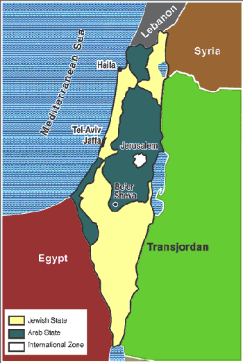
Where is the contradiction? They look identical to me. The material I quoted said, “These boundaries were based solely on demographics.� So does yours. What’s the problem?
Further: What’s the relevance of this Resolution anyway?
Partition was REJECTED by the Arabs; they chose war instead, remember?
Here are a few other provision of that Resolution that you have card-stacked away:
General Provision
The stipulations contained in the Declaration are recognized as fundamental laws of the State and no law, regulation or official action shall conflict or interfere with these stipulations, nor shall any law, regulation or official action prevail over them.
Chapter I: Holy Places, Religious Buildings and Sites
Existing rights in respect of Holy Places and religious buildings or sites shall not be denied or impaired.
In so far as Holy Places are concerned, the liberty of access, visit, and transit shall be guaranteed, in conformity with existing rights, to all residents and citizen of the other State and of the City of Jerusalem, as well as to aliens, without distinction as to nationality, subject to requirements of national security, public order and decorum.
Similarly, freedom of worship shall be guaranteed in conformity with existing rights, subject to the maintenance of public order and decorum.
Holy Places and religious buildings or sites shall be preserved. No act shall be permitted which may in an way impair their sacred character. If at any time it appears to the Government that any particular Holy Place, religious, building or site is in need of urgent repair, the Government may call upon the community or communities concerned to carry out such repair. The Government may carry it out itself at the expense of the community or community concerned if no action is taken within a reasonable time.
These provisions were honored by the Israelis; by the Arabs, not at all. The Western Wall was made into a public latrine and garbage dump, and Jews were not permitted access to it.
And then there is this:
Chapter 3: Citizenship, International Conventions and Financial Obligations
1. Citizenship
Palestinian citizens residing in Palestine outside the City of Jerusalem, as well as Arabs and Jews who, not holding Palestinian citizenship, reside in Palestine outside the City of Jerusalem shall, upon the recognition of independence, become citizens of the State in which they are resident and enjoy full civil and political rights. Persons over the age of eighteen years may opt, within one year from the date of recognition of independence of the State in which they reside, for citizenship of the other State, providing that no Arab residing in the area of the proposed Arab State shall have the right to opt for citizenship in the proposed Jewish State and no Jew residing in the proposed Jewish State shall have the right to opt for citizenship in the proposed Arab State. The exercise of this right of option will be taken to include the wives and children under eighteen years of age of persons so opting.
This was also honored by the Israelis; as I have pointed out many,
many, MANY times,
and as you have never, to date, acknowledged, very many Arabs STAYED in Israel, became full citizens, and they and their descendants remain full citizens today; 20% of the population of Israel is Arab, and they are so represented in the Israeli Knesset. Will you just ignore that FACT yet again, as you have consistently done for the last year or so? Or will you finally explain how it can be reconciled with your polemic?
Jews who were in that part of Palestine controlled by the Arabs at the time of partition were driven out at gunpoint. ALL of them. There were just as many Jewish refugees driven from Arab lands as there were Arabs who left Israel, voluntarily or not. You’ve never commented on that, either.
One-sided “Card Stacking� yet again.
Also, pre-Nakbar Palestine was overwhelmingly owned by Arab Palestinians, Muslim or Xtian. So it had been for centuries. Only the sudden massive influx of illegal aliens from Russia and other foreign nations that resulted in violence and land theft changed that Arab domination.[/b]
Repeating the claim doesn’t make it so. Further, the overwhelming majority of Jews in Palestine moved there legally and bought their land legally (often from absentee Arab landowners). Both my map and yours agree that the majority of the land which became Israel was inhabited by a Jewish majority.
Further, there is the issue of ARAB illegal immigration. This, among other topics, is examined in
The Claim of Dispossession: Jewish Land-Settlement and the Arabs, 1878-1948, by Arieh L. Avneri:
This exceedingly well-documented book lays bare the false claim that Jewish settlers dispossessed Arab people from their land in Palestine. The examination of records from 1830 onward will shock most readers.
In the first place, the book shows that Palestine's population barely grew for 250 years--rising from 205,000 Moslems, Christians and Jews in 1554 to only 275,000 in 1800. In the second, records from 1830, 1863, 1878 and 1893 and 1917, among others, demonstrate that when the heaviest Jewish immigration began in 1880, a large proportion of the 425,000 to 440,000 Arabs in Palestine were themselves recent immigrants.
The book also carefully documents the origins of those immigrants. Many came from Egypt: The 1831 invasion by the Egyptian Khedive, Ibrahim Pasha, forced Palestine fellaheen, urban dwellers and Bedouin to permanently flee Ottoman military drafts and taxes. The 1837 Great Earthquake and epidemics that followed further cut their numbers. In their wake came Ibrahim Pasha's Egyptian Arabs, who settled the empty land. In 1831 alone, 6,000 Egyptian Arabs settled in Akko. The Egyptian Arab-Hinadi, Ghawarna tribes settled in the Beit Shean and Hula Valleys and in the Jordan Valley towns of Ubeidiya, Delhamiya and Kafer-Miser. In the Hula Valley, the Egyptian ez-Zubeids later sold their land to Jewish settlers from Yessud-Hama'ala. According to an 1893 British Palestine Exploration Fund report, Egyptians made up most of the population in Jaffa.
Additionally, Avneri shows, Arab and Muslim immigrants also came from Algeria, Damascus, Yemen, Afghanistan, Persia, India, Tripoli, Morocco, Turkey and Iraq. The French conquest of Algeria, for example, led to the eventual rebellion and imprisonment of Abd el-Kadar el-Hassani, whose followers in 1856 fled to Syria and the Lower Galilee towns of Shara, Ulam, Ma'ader, Kafer-Sabet, Usha (near present-day Ramat-Yohanan), the Mount Atlas village of Qedesh and villages on Lake Hula and in the Upper Galilee, where they spoke Berber. In Ramle, immigrants spoke Qebili, a Mugrabi dialect. Circassian refugees from the Caucasus settled in Trans-Jordan and as far east as Caesarea.
Arab immigration continued to rise through World War I, as Avneri documents, despite locusts, the Ottoman draft and more epidemics. Egyptian laborers, contractors and businessmen flooded the country. By 1922, the Moslem population had more than doubled to 566,311, including 62,500 Bedouins. The 1931 Mandatory government census counted 693,147 permanent Moslem residents, including 66,553 Bedouins. It also gave the natural increase of the population as 132,211--57,125 less than the absolute increase. Only illegal Arab immigration explains this contradiction, Avneri shows.
The next census in 1948, as Avneri recounts, followed unprecedented economic growth, during which illegal Arab immigration continued. From April 1934 to November 1935, for example, 20,000 Haurani Arabs came to Palestine. These and thousands of other Arab immigrants worked on farms, construction projects (building roads, railroads and the Haifa port), and government and municipal jobs. Syrians and Lebanese Arabs were free to come with nothing but border passes, and they came along with immigrants from Somalia, Trans-Jordan, Persia, India, Ethiopia and the Hejaz. Mandatory government rules required the supervision of immigration, but Palestine's borders remained porous to all but Jews. In all, Avneri shows that 35,000 to 40,000 illegal Arab immigrants came from 1931 to 1947--on top of up to 20,000 other Arab immigrants who arrived from 1935 to 1945.
The book also carefully examines numerous historical descriptions of a desolate landscape, composed almost entirely of swamps and deserts, and sold to the Jewish people by absentee Arab landlords, appointed by the Ottoman government, at enormous profits. Dozens of sales are documented specifically, including some by the Egyptian el-Husseini family of Yasser Arafat.
Altogether, this book shatters the Arab claim of dispossession.
If Jewish "illegal immigration" is relevant, so is this. The fact, which I have documented elsewhere, is that the Arab population increased in Jewish areas AFTER the Jews came, because the living standard and conditions were higher there. No comment on that, either, of course. Doesn't fit your mythology.
The idea that Israel was “stolen� from the Arabs is, simply put, a myth;
We can say conquered, overrun, seized, or any term you want. The end result was that even Ariel Sharon admitted that Palestine was Occupied territory.
•occupied - seized and controlled as by military invasion; "the occupied countries of Europe"
Was Sharon speaking of Israel proper? Or was he speaking of the West Bank? Will you give the full quote, the context,
and your source?
You have still posting nothing but CLAIMS. Can you document them? Can you answer the simple question of WHY so many Arabs STAYED in Israel and are STILL THERE, living in peace as full citizens? Or will you continue to pretend that you’ve never heard that, don’t know it, and that no such statement has ever been made?

TANNER, H.S./S.A. MITCHELL.
PALESTINE & ADJACENT COUNTRIES. H.N. BURROUGHS. PHILADELPHIA. 1846. FULL HAND COLOR. COPPER ENGRAVING. "Published by S. Augustus Mitchell." First Mitchell edition of this Tanner map. With inset of the environs of Jerusalem. Margins off center. 15.5"H. x 12.5"W. GOOD. $150.00. I.D.#07988.
http://www.murrayhudson.com/antique_map ... stine.html
So a map published
more than a century before partition does not show a nation called “Israel�?
So what? "Palestine" didn't exist then, either; it referred to a geographical area, not a nation. I can show you any number of maps that show Israel and Judah 1500 years ago or so, and
they aren't relevant either.
And, of course, there is STILL this:
Again, no acknowledgment of the decades-long campaign of Palestinian attacks against unarmed civilians chosen as primary targets for mass murder; no acknowledgment of the responsibility of the Palestinian terrorists for the deaths of Palestinian civilians due to their own inarguably criminal tactics; no acknowledgment of the openly and explicitly stated, and never renounced, Palestinian goal of the total eradication of Israel and the extermination or expulsion of every Jew in the Mideast; no acknowledgment of the decades of Government-sponsored and encouraged old-school Nazi-style anti-Semitic hate propaganda to which the Arab public is subjected; no acknowledgment of Holocaust denial, claims of worldwide Jewish conspiracy promoting the Protocols of the Elders of Zion as authentic, and even dramatizations of the notorious Blood Libel as factually true; no acknowledgment of the Palestinian goal of “ethnic cleansing� in order to establish a Judenrein Arab nation in the West Bank, and eventually from the Jordan to the sea; no acknowledgment that many Arabs never left Israel, and live there in peace and freedom as full citizens to this day; no acknowledgment of endlessly repeated Israeli offers of “land for peace�; no acknowledgment of the blatant anti-Israel bias of the UN; and, finally, no acknowledgment of the FACT that looking to mutually exclusive historical narratives of the past offers no solutions, only more endless conflict. In short, no acknowledgment of anything but the unquestioning embrace of pure Palestinian propaganda, often including fake and fabricated “quotes� clearly intended to inflame and promote hatred and resentment, and of course your favorite inflammatory and fact-free propaganda cartoons.
When you're ready to actually acknowledge and talk about some of the FACTS above, and therefore to actually engage in meaningful debate as opposed to peddling one-sided propaganda, let me know.
You have bravely alluded to this paragraph on another thread; will you FINALLY address the issues in it here and now?
Or anywhere, or ever?


