Drumlins, Ribbed Moraines, and Giant Ripples

Creationism, Evolution, and other science issues

Moderator: Moderators

User avatar
otseng
Savant
Posts: 20791
Joined: Thu Jan 15, 2004 1:16 pm
Location: Atlanta, GA
Has thanked: 211 times
Been thanked: 360 times
Contact:

Drumlins, Ribbed Moraines, and Giant Ripples

Post #1

Post by otseng »

This thread is an offshoot of the Channeled Scablands thread.

In that thread, I asked "If a catastrophic flood created the Scablands in a short period of time, couldn't other geological features elsewhere be also created in a short amount of time?"

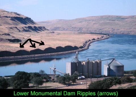
One of the features in the Scablands are the giant ripple marks.

Image
http://www.detectingdesign.com/harlenbretz.html

Similar to giant ripple marks are drumlins and ribbed moraines.

Question for debate:
How did all these giant ripples form?

User avatar
Goat
Site Supporter
Posts: 24999
Joined: Fri Jul 21, 2006 6:09 pm
Has thanked: 25 times
Been thanked: 207 times

Post #41

Post by Goat »

otseng wrote:As I've demonstrated, water action is the best explanation of drumlins, ribbed moraines and ripples. We see such things all the time on a small scale at beaches and rivers.

As for ice action, there are no adequate explanations of these formations.
Drumlins are streamlined ice-moulded glacial bedforms which are generally elliptical in plan view. Despite over thirty years of intensive study, the exact conditions and processes responsible for their formation remain undetermined.
http://voa.soc.soton.ac.uk/soes/researc ... mlins.php3

It's proposed that glaciers melting can leave these formations. Yet, this is conjecture since there are no evidence that glaciers now have produced drumlins or ribbed moraines. And there is not even a mechanism proposed on how this can occur.

And we even have drumlins that are more than 150 ft high. How can that be formed by a retreating glacier?
Drumlins, which may be more than 150 ft (45 m) high and more than 1/2 mi (.8 km) long, are common in New York, Wisconsin, Canada, and Northern Ireland.
http://www.encyclopedia.com/doc/1E1-drumlin.html

So, water action is the most logical explanation. Yet, why do geologists still claim that they are formed by ice?

There is only one reason. It would lend credence to the Biblical flood and that is unacceptable to naturalistic scientists.
Geologists customarily explain drumlins as debris piled up and sculpted by the ice sheets themselves, despite the fact they look like they might have been shaped by flowing water. As we all know, the word "flood" is an anathema in geology, probably because a provable episode of extensive flooding would lend credence to the Biblical Flood!
http://www.science-frontiers.com/sf066/sf066g11.htm

So, rather than dismiss a hypothesis based on its implications, geologists should simply choose which is the better hypothesis based on evidence and the most plausible explanation.
If it is water action, why can't we find drumlins only where there is evidence of glaciers because of scraps in the bedrock? Why can't we find them anyplace
there is water?

Would not the melt off of retreating glaciers be a source of water to create drumlins?

User avatar
otseng
Savant
Posts: 20791
Joined: Thu Jan 15, 2004 1:16 pm
Location: Atlanta, GA
Has thanked: 211 times
Been thanked: 360 times
Contact:

Receding water hypothesis

Post #42

Post by otseng »

goat wrote:Would not the melt off of retreating glaciers be a source of water to create drumlins?
I don't think so. Primarily because it would require a lot of water to form them, much more than water coming from a melting glacier. Though I guess ice dams could possibly provide sufficient water.
If it is water action, why can't we find drumlins only where there is evidence of glaciers because of scraps in the bedrock? Why can't we find them anyplace there is water?
Now would be a good time to propose my hypothesis on their formation.

As I've said, drumlins, ribbed moraines, and ripples are caused by water action. They are formed by water receding into the lower elevations during the global flood.

But, if the flood covered the whole world, shouldn't we see these formations all over the world?

My hypothesis is that it should only be formed where the base is primarily igneous rock. Some might be metamorphic. And very little, if any, would be sedimentary.

During the global flood, practically all the sedimentary rocks and some of the metamorphic rocks were formed at this time. Most rocks prior to the flood was either igneous or metamorphic. Sedimentary layers were loose wet dirt during the flood.

As water receded over areas where there is a thin layer of sedimentary layers (wet loose soil) on top of igneous/metamorphic rock (solid rock), it would wash it away. But because of the hard rock underneath, it could cause drumlins, ribbed moraines, and ripples to form.

It would also require an elevation difference for them to form. Either from land to sea level. Or from a mountainous area to land.

Scrapes in rocks would be caused by rocks in the receding flood water rubbing against them.

My hypothesis would then be testable by seeing what kinds of rocks are under drumlins. It should be mostly igneous and some metamorphic rock. Also, it would have to be near a mountain or have an elevation difference. It should not exist on flat areas that is not close to a mountain range.

User avatar
Goat
Site Supporter
Posts: 24999
Joined: Fri Jul 21, 2006 6:09 pm
Has thanked: 25 times
Been thanked: 207 times

Re: Receding water hypothesis

Post #43

Post by Goat »

otseng wrote:
goat wrote:Would not the melt off of retreating glaciers be a source of water to create drumlins?
I don't think so. Primarily because it would require a lot of water to form them, much more than water coming from a melting glacier. Though I guess ice dams could possibly provide sufficient water.
The icefield that extends from the poles down through canada to wisconsion certainly has enough volumn of ice to cause a great deal of runoff.

As a matter of fact, I found this web site just now

http://www.sentex.net/~tcc/sgfcrit.html
Since 1983, several investigators have developed a theory of drumlin formation by catastrophic flooding due to the release of meltwater that is believed to have accumulated beneath melting ice sheets. The proposed catastrophic sheet floods, as wide as the drumlin fields, formed the drumlins and related streamlined landforms, such as flutings, over wide areas. So-called rogen moraine, consisting of transverse ridges of drift, often found associated with drumlins, is reinterpreted in the meltwater flood hypothesis as possible giant current ripples.

If it is water action, why can't we find drumlins only where there is evidence of glaciers because of scraps in the bedrock? Why can't we find them anyplace there is water?
Now would be a good time to propose my hypothesis on their formation.

As I've said, drumlins, ribbed moraines, and ripples are caused by water action. They are formed by water receding into the lower elevations during the global flood.

But, if the flood covered the whole world, shouldn't we see these formations all over the world?

My hypothesis is that it should only be formed where the base is primarily igneous rock. Some might be metamorphic. And very little, if any, would be sedimentary.

During the global flood, practically all the sedimentary rocks and some of the metamorphic rocks were formed at this time. Most rocks prior to the flood was either igneous or metamorphic. Sedimentary layers were loose wet dirt during the flood.

As water receded over areas where there is a thin layer of sedimentary layers (wet loose soil) on top of igneous/metamorphic rock (solid rock), it would wash it away. But because of the hard rock underneath, it could cause drumlins, ribbed moraines, and ripples to form.

It would also require an elevation difference for them to form. Either from land to sea level. Or from a mountainous area to land.

Scrapes in rocks would be caused by rocks in the receding flood water rubbing against them.

My hypothesis would then be testable by seeing what kinds of rocks are under drumlins. It should be mostly igneous and some metamorphic rock. Also, it would have to be near a mountain or have an elevation difference. It should not exist on flat areas that is not close to a mountain range.
That still does not explain why we see drumlins in the north, where there is other evidence of glacial activity, yet none anyplace else.

How does your theory account that we see them basically in a line in the northern part of the U.S and lower Canada, yet none in , lets say Mexico, or south America.

Why is the drumlins are where here is generally north/south scraps in the bedrock that we see where glaciers retreat? What part of your theory explains that pattern. Why do we , for example, see erratics boulder of many tons of size south of where their origin. How does your hypothesis explain that data? Can you show that water flowing can cause these massively parallel lines found in the bedrock. Can you explain why we see those exact same lines underneath the current retreating glaciers, and none south of the Maison Dixon line?

Can you set up an experiment that can show that water erosion alone can cause these very straight lines to form . We can see them by glaciers do form them by going to where glaciers are retreating, and seeing that same pattern on the bedrock where the glaciers are melting away.

Can you explain why we see those pattern in front of retreating glaciers , and not , for example, in more tropical areas where glaciers are not in existence? I would like to see some empirical data that shows that water erosion can form that pattern

User avatar
micatala
Site Supporter
Posts: 8338
Joined: Sun Feb 27, 2005 2:04 pm

Post #44

Post by micatala »

otseng wrote: My hypothesis would then be testable by seeing what kinds of rocks are under drumlins. It should be mostly igneous and some metamorphic rock. Also, it would have to be near a mountain or have an elevation difference. It should not exist on flat areas that is not close to a mountain range.
This would be a reasonable test that could falsify your theory. HOwever, it does seem to me that even if passed, it does not provide very compelling evidence of the correctness of the theory. The 'rock criteria' could also apply to ice formation of these features.

goat also raises some other relevant issues.

User avatar
Jose
Guru
Posts: 2011
Joined: Thu Sep 02, 2004 4:08 pm
Location: Indiana

Post #45

Post by Jose »

otseng wrote:My hypothesis would then be testable by seeing what kinds of rocks are under drumlins. It should be mostly igneous and some metamorphic rock. Also, it would have to be near a mountain or have an elevation difference. It should not exist on flat areas that is not close to a mountain range.
Well let's see here...

First, an answer to the question of drumlin composition:
William A. White wrote:Some drumlins unquestionably were carved out of pre extant stuffs for they include such diverse components as tills, Paleozoic bed rock, lake beds, and waterlaid, cross bedded sands and gravels. Sometimes two or three different components are in the same drumlin, as in Maclntyre Bluff on the shore of Lake Ontario near Fairhaven, New York. There wave erosion has exposed the interior of a drumlin made of two layers of till separated by a stratum of clean water-washed cross bedded sand which extends all the way across the drumlin and is abruptly trun-cated on both sides of it. Similar features are noted by Muller (1974)near Syracuse, New York. (from here
So, it looks like drumlins are made from local material, of whatever type it may be.

White provides this map:
Image
The image is too big, I'm afraid, but the point is important. The smaller drumlins are all north of the Waterloo terminal moraine. White suggests that this was a single drumlin field, but that the Waterloo glacier broke into the water of the lake and created a sort of Slushie slopping back and forth, streamlining the drumlins.
Panza llena, corazon contento

User avatar
otseng
Savant
Posts: 20791
Joined: Thu Jan 15, 2004 1:16 pm
Location: Atlanta, GA
Has thanked: 211 times
Been thanked: 360 times
Contact:

Re: Receding water hypothesis

Post #46

Post by otseng »

goat wrote: The icefield that extends from the poles down through canada to wisconsion certainly has enough volumn of ice to cause a great deal of runoff.
But how can it all melt at the same time?
As a matter of fact, I found this web site just now

http://www.sentex.net/~tcc/sgfcrit.html
Actually, the author is pointing out some problems with the meltwater theory and proposes instead flood action.
In the theory of drumlin formation proposed by Cox, newly deposited sediment and bedrock were streamlined by vortices in fast currents of the flood.
goat wrote: That still does not explain why we see drumlins in the north, where there is other evidence of glacial activity, yet none anyplace else.
My receding flood water hypothesis only states that it could occur where the sedimentary layers are almost nonexistent. And I think there seems to be a correlation between the thinness of the sedimentary layers and how close it is to the poles. And I'm currently trying to confirm if this is true. And if it is, why would this be so.
Why is the drumlins are where here is generally north/south scraps in the bedrock that we see where glaciers retreat? What part of your theory explains that pattern.
I think I'd like to have a separate thread to discuss glacial striations. But, I'd explain it by rocks in sediment loaded flood waters to cause those patterns.
Why do we , for example, see erratics boulder of many tons of size south of where their origin.

I'd like to discuss this in the erratics thread.
Jose wrote:So, it looks like drumlins are made from local material, of whatever type it may be.
To be clear, drumlins are of course made from local material. What I'm hypothesizing is what is under the drumlins. The base rock under drumlin fields, ribbed moraines, and ripple fields should primarily be igneous/metamorphic rock.

User avatar
Jose
Guru
Posts: 2011
Joined: Thu Sep 02, 2004 4:08 pm
Location: Indiana

Post #47

Post by Jose »

otseng wrote:
goat wrote:That still does not explain why we see drumlins in the north, where there is other evidence of glacial activity, yet none anyplace else.
My receding flood water hypothesis only states that it could occur where the sedimentary layers are almost nonexistent. And I think there seems to be a correlation between the thinness of the sedimentary layers and how close it is to the poles. And I'm currently trying to confirm if this is true. And if it is, why would this be so.
I think the following image will show that this is not so:
Image
This is a photo of the McKenzie mountains in the Northwest Territories. There's lots of sedimentary rock here--look at the strata visible in the photo. I think you are thinking of the contiguous 48 states of the US. Here, the coasts have lots of sedimentary rock, while the midwest has much less. The geological explanation is that the center of the continent tends to be above water most of the time. The edges of the North American Plate dip under water as the plate tilts from side to side, but the point around which it tilts is the midwest. So, in Minnesota, Wisconsin, etc the sediments are thinner. But, if we north through Canada, we can find some good sedimentary rock layers.
otseng wrote:My hypothesis would then be testable by seeing what kinds of rocks are under drumlins. It should be mostly igneous and some metamorphic rock. Also, it would have to be near a mountain or have an elevation difference. It should not exist on flat areas that is not close to a mountain range. ...
Jose wrote:So, it looks like drumlins are made from local material, of whatever type it may be.
To be clear, drumlins are of course made from local material. What I'm hypothesizing is what is under the drumlins. The base rock under drumlin fields, ribbed moraines, and ripple fields should primarily be igneous/metamorphic rock....
Well, this is something we can check, thanks to the oil geologists who have drilled core samples from all over. Here's a map of part of Wisconsin and Michigan that shows the bedrock in colors, and the drumlins as black dots:
Image
From http://www.casdn.neu.edu/~geology/depar ... eodrum.JPG
A map with a key, albeit using different colors, can be seen here, from which we can summarize as follows: the northern drumlin fields are over precambrian rock, which would be primarily metamorphic (whether its origin was igneous or sedimentary). The southern field, however, is over rock that ranges from Cambrian (upper left part of this field) through Odovician and Silurian, to a small patch of Devonian on the far right. These are sedimentary.

Of course, below these there will be precambrian rocks. So, at some level, your prediction is correct: the drumlin fields are over precambrian (metamorphic) rock, though we may have to dig down a few thousand feet to get to this rock.

As for the mountain ranges, there are few here. There are bluffs along the lakes, and there are the drumlins, but there is little that is of significant elevation. There are drumlins near the Rockies, such as (these in Waterton Lakes National Park. They are "pointed" downhill, away from the mountains and out toward the plains. They are right by the gate to the park, which indicates that they are essentially on the plains, right where the mountains rise up.

Now, there's an interesting thing here. It's not very easy to find photos or discussions of drumlins near the Rockies. Those that turn up tend to be in/near the Canadian Rockies, where there was also glaciation from the north. By contrast, there seem to be bazillions of drumlins along the southern front of the Wisconsonian glacier, where the elevation change is much less than the Rockies. I think the data rule out the idea that drumlins need to be near mountains.
Panza llena, corazon contento

User avatar
otseng
Savant
Posts: 20791
Joined: Thu Jan 15, 2004 1:16 pm
Location: Atlanta, GA
Has thanked: 211 times
Been thanked: 360 times
Contact:

Post #48

Post by otseng »

Jose wrote:This is a photo of the McKenzie mountains in the Northwest Territories. There's lots of sedimentary rock here--look at the strata visible in the photo. I think you are thinking of the contiguous 48 states of the US.
Of course there are a lot of sedimentary rock in the mountain ranges of Canada. But, from what I can gather, the rest of Canada does not have much sedimentary rock.

Image
http://igs.indiana.edu/Geology/structur ... /index.cfm

"The Canadian Shield is a large shield covered by a thin layer of soil that forms the nucleus of the North American craton."
http://en.wikipedia.org/wiki/Canadian_Shield

And to compare it with areas thought to be glaciated, there is a rough correlation.

Image
http://www.esd.ornl.gov/projects/qen/ne ... ERICA.html

In particular, the areas in the eastern coast of Canada, northern Canada near the Arctic Ocean, and Alaska where the shield are not exposed is where glaciation is thought not to occur.

And how would the ice age theory explain why these areas would not have glaciers?
So, at some level, your prediction is correct: the drumlin fields are over precambrian (metamorphic) rock, though we may have to dig down a few thousand feet to get to this rock.
Do you have a reference where the sedimentary layers here are a few thousand feet?
I think the data rule out the idea that drumlins need to be near mountains.
I hypothesize it should occur near mountains or have an elevation gradient. Basically, something that would allow water runoff.

User avatar
Jose
Guru
Posts: 2011
Joined: Thu Sep 02, 2004 4:08 pm
Location: Indiana

Post #49

Post by Jose »

otseng wrote:Of course there are a lot of sedimentary rock in the mountain ranges of Canada. But, from what I can gather, the rest of Canada does not have much sedimentary rock.
Quite true. But, this fact doesn't help distinguish between our arguments. Standard tectonic theory states that the Stable Craton (the Canadian shield) is the center of buoyancy of the North American Plate. It's like the center of a raft, which may tip and tilt, with the edges getting covered with water (and sediment), but the center of buoyancy stays dry. Therefore, sediments and mountains should be around the coasts, but the center of the continent should be relatively free of such stuff.
otseng wrote:And to compare it with areas thought to be glaciated, there is a rough correlation.
Again, this fits with either model. For drumlins to be the result of glaciation, there must be glaciers :)
otseng wrote:In particular, the areas in the eastern coast of Canada, northern Canada near the Arctic Ocean, and Alaska where the shield are not exposed is where glaciation is thought not to occur.

And how would the ice age theory explain why these areas would not have glaciers?
Well...it may depend somewhat on which map we look at. Consider this one:
Image
This map purports to show the maximum glaciation, at the maximum extension of the Laurentide Ice Sheet. Here, the east coast of Canada is covered. I suspect that different maps may show somewhat different timepoints. Some that I've found are intermediate between your map and this one, with the ocean between Canada and Greenland open, rather than covered. I'd probably favor the idea that this part of the ocean was more like the Arctic ice cover now--frozen over in winter, but sometimes breaking up in the summer, and always much thinner than ice that is over land. The ocean kinda nibbles away at the bottom of the ice (or so I understand the thinking behind the thinness of Arctic ice compared to glaciers.

The same logic would explain why your map shows less ice coverage along the coast (or rather, a different ecological zone, if I read the original page correctly). Oceans tend to moderate the climate near them.

So, we can probably waffle a bit, or wave our hands, and make sense of the various maps.

I've had an interesting thought, as I look at what you've said. You ask how the Ice Age theory would explain this region not being covered. I suggest that this is inverted reasoning. The data are the moraines, drumlins, erratics, scrape marks, kettle holes, etc. The best explanation, according to those who have made this puzzle their life's work, is the Ice Age Theory. Other data fit this theory, such as O-16/O-18 ratios in ocean carbonate sediments; this varies with temperature, and can be used to infer the ocean temperature in the past. So, rather than phrase it as "how would the theory explain the east coast having less ice" we might want to ask "given that there seems to have been less ice on the east coast, when there was more ice elsewhere, how can we explain the findings?" The theory comes from the data.

So, a simple Ice Age theory would be devised from the moraines and drumlins. It might posit that ice spread from the north pole in all directions equally. But this theory would be blown by the finding that the east coast was less ice-covered. It would also be blown by the finding that Alaska was less covered. So, we must examine the theory and see what modifications are needed. One seems to be that the position of the north pole was different then, so Alaska was farther away (or so I've heard). I've suggested another above--the moderation of climate by nearby ocean.

In any event, the question is actually about the geological features, and whether we can attribute them to water rather than ice...so let's continue...
otseng wrote:
Jose wrote:So, at some level, your prediction is correct: the drumlin fields are over precambrian (metamorphic) rock, though we may have to dig down a few thousand feet to get to this rock.
Do you have a reference where the sedimentary layers here are a few thousand feet?
Good question. I appear to have conflated the Midwest data with the data from the Rockies. The numbers I can find indicate that there may be several hundred feet of sediment over the Precambrian rock in southern Wisconsin. I can't quite tell whether we're talking 300 feet for Cambrian through Devonian, or roughly 300 feet for each.

On the other hand, the drumlins in the mouths of the valleys of Glacier/Waterton National Park are over thousands of feet of sediment. I've looked through the data from drill cores in this region (for another project). We're talking more than 6000 feet before hitting Precambrian. So there, at least, there's plenty of sedimentary rock below the drumlins.

It turns out that there are drumlin fields in many places where we don't have continental shields. I've mentioned those in Glacier/Waterton before. There appear, also, to be drumlins in the Andes and Patagonia.

But, we don't seem to see them in the mouths of just any mountain canyon. Canyons with V-shaped cross sections don't seem to have them, while canyons with U-shaped cross sections sometimes do. Those of Glacier/Waterton are U-shapes. The Yosemite valley and its tributary hanging vallies, or the analogous vallies in and around Telluride, don't have drumlins below them. They switch to V-shaped canyons before they run onto more level ground. That is: drumlins seem to be associated with canyons carved by glaciers. They don't appear near canyons carved by water. Drumlins seem to be associated with polar areas, elevation or not, and with mountainous areas that are close enough to the poles to have sustained major glaciers that reached the foothills.
otseng wrote:
Jose wrote:I think the data rule out the idea that drumlins need to be near mountains.
I hypothesize it should occur near mountains or have an elevation gradient. Basically, something that would allow water runoff.
Either model requires a gradient, either for water or ice to move downhill. For the Canadian Shield, "downhill" seems to have been relatively horizontal, as ice piled up in the polar regions and the ice was squished farther south. For mountains, there is of course an elevation gradient, since that kinda defines "mountains."

But, we seem to have three kinds of regions to account for with any model: (1) the relatively horizontal drumlin fields of the Midwest and Canada, (2) the smaller drumlin fields at the mouths of some glacially-carved canyons, and (3) no drumlin fields at the mouths of canyons that were carved by running water. We seem to need glacial activity opening onto a relatively non-steep area. We'd thus propose that earlier glaciers produced terminal moraines on these relatively flat areas, and that later glaciers advanced over the moraines, grinding them into drumlins. Without glacial activity, there's no terminal moraine to modify into drumlins. Without the relatively flat area, subsequent glacial melt would create enough water in the canyon to erode whatever moraines or drumlins might have been there (as with Yosemite).

So, we might be able to say that water runoff could create drumlins, as you suggest--but that subsequent runoff in mountains eroded them away. It's a good idea. But, I think it runs counter to the suggestion that the canyons themselves were carved by Flood runoff (the classic example being the Grand Canyon). We run into a problem, then. The Ice Model explains the data neatly. The Flood Model requires some way of distinguishing which canyons get drumlins and which ones don't. We can't use steep mountains opening onto plains, because the Colorado comes out of the Rockies (nice and steep) and opens onto the plains (no drumlins). And then, the darned thing turns sharply to the right, and plows into the uplift that rises on either side, to form the Grand Canyon. Still no drumlins. By the logic of taking the simplest explanation as the most reasonable, we'd have to go with ice.
Panza llena, corazon contento

User avatar
otseng
Savant
Posts: 20791
Joined: Thu Jan 15, 2004 1:16 pm
Location: Atlanta, GA
Has thanked: 211 times
Been thanked: 360 times
Contact:

Post #50

Post by otseng »

Jose wrote:Standard tectonic theory states that the Stable Craton (the Canadian shield) is the center of buoyancy of the North American Plate. It's like the center of a raft, which may tip and tilt, with the edges getting covered with water (and sediment), but the center of buoyancy stays dry. Therefore, sediments and mountains should be around the coasts, but the center of the continent should be relatively free of such stuff.
Not sure how this explains the lack of sedimentary rock on the Canadian shield or why glaciers would not be found at the areas I mentioned, but I'll go on.
Image
This map purports to show the maximum glaciation, at the maximum extension of the Laurentide Ice Sheet.
However, there are evidence of erratics in areas south of the maximum glaciation on your map. Kansas, California, Arizona, Utah, and Kentucky are some that I've been able to uncover.

How can it be explained that there are erratics at these locations, but no drumlins?
I suspect that different maps may show somewhat different timepoints.
The map I quoted stated it was the "most extreme stage of the last glaciation". So, my suspicion is that geologists are not in a consensus of exactly what is the maximum extent of glaciation.
You ask how the Ice Age theory would explain this region not being covered. I suggest that this is inverted reasoning. The data are the moraines, drumlins, erratics, scrape marks, kettle holes, etc.
I would assume that they determined the maximum glaciation through the data you described. But, since there doesn't seem to be agreement on exactly what areas were glaciated or not, then it's probably pointless to debate about specific maps.
One seems to be that the position of the north pole was different then, so Alaska was farther away (or so I've heard).
But the last glaciation was less than 20,000 years ago. So, I doubt there'd be much difference in their locations (North Pole or Alaska).
But, we don't seem to see them in the mouths of just any mountain canyon. Canyons with V-shaped cross sections don't seem to have them, while canyons with U-shaped cross sections sometimes do. Those of Glacier/Waterton are U-shapes. The Yosemite valley and its tributary hanging vallies, or the analogous vallies in and around Telluride, don't have drumlins below them. They switch to V-shaped canyons before they run onto more level ground. That is: drumlins seem to be associated with canyons carved by glaciers. They don't appear near canyons carved by water. Drumlins seem to be associated with polar areas, elevation or not, and with mountainous areas that are close enough to the poles to have sustained major glaciers that reached the foothills.
My guess is that V-shaped canyons would have too fast of a water flow to be able to form drumlins.

Also, how are glaciers able to "carve" out a canyon?
Either model requires a gradient, either for water or ice to move downhill. For the Canadian Shield, "downhill" seems to have been relatively horizontal, as ice piled up in the polar regions and the ice was squished farther south.
I wouldn't necessarily describe the Canadian shield as relatively horizontal. From the north to south, it is generally uphill. Which runs counter to the direction of how glaciers generally move.

Image
http://atlas.nrcan.gc.ca/site/english/m ... image_view
We'd thus propose that earlier glaciers produced terminal moraines on these relatively flat areas, and that later glaciers advanced over the moraines, grinding them into drumlins. Without glacial activity, there's no terminal moraine to modify into drumlins.
From what I can tell, the most common explanation of the origin of drumlins is deposition of till contained in the retreating glaciers.

"The most widely accepted idea is that they were formed when the ice became overloaded with sediment. When the competence of the glacier was reduced, material was deposited, in the same way that a river overloaded with sediment deposits the excess material."
http://www.geography-site.co.uk/pages/p ... /drum.html

But, some questions about your explanation.

How can it be explained for areas that have both terminal moraines and drumlins? For example, Withrow Moraine and Jameson Lake Drumlin Field.

If a glacier "grinded" over a hill, shouldn't it be expected to flatten it rather than leave other hills?

What would determine if a glacier would carve out a lake/canyon/etc versus forming moraines/drumlins?
By the logic of taking the simplest explanation as the most reasonable, we'd have to go with ice.
Of course, I believe the simplest is still water. :)

Post Reply