otseng wrote:Of course there are a lot of sedimentary rock in the mountain ranges of Canada. But, from what I can gather, the rest of Canada does not have much sedimentary rock.
Quite true. But, this fact doesn't help distinguish between our arguments. Standard tectonic theory states that the Stable Craton (the Canadian shield) is the center of buoyancy of the North American Plate. It's like the center of a raft, which may tip and tilt, with the edges getting covered with water (and sediment),
but the center of buoyancy stays dry. Therefore, sediments and mountains should be around the coasts, but the center of the continent should be relatively free of such stuff.
otseng wrote:And to compare it with areas thought to be glaciated, there is a rough correlation.
Again, this fits with either model. For drumlins to be the result of glaciation, there must be glaciers

otseng wrote:In particular, the areas in the eastern coast of Canada, northern Canada near the Arctic Ocean, and Alaska where the shield are not exposed is where glaciation is thought not to occur.
And how would the ice age theory explain why these areas would not have glaciers?
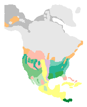
Well...it may depend somewhat on which map we look at. Consider this one:

This map purports to show the maximum glaciation, at the maximum extension of the Laurentide Ice Sheet. Here, the east coast of Canada is covered. I suspect that different maps may show somewhat different timepoints. Some that I've found are intermediate between your map and this one, with the ocean between Canada and Greenland open, rather than covered. I'd probably favor the idea that this part of the ocean was more like the Arctic ice cover now--frozen over in winter, but sometimes breaking up in the summer, and always much thinner than ice that is over land. The ocean kinda nibbles away at the bottom of the ice (or so I understand the thinking behind the thinness of Arctic ice compared to glaciers.
The same logic would explain why your map shows less ice coverage along the coast (or rather, a different ecological zone, if I read the original page correctly). Oceans tend to moderate the climate near them.
So, we can probably waffle a bit, or wave our hands, and make sense of the various maps.
I've had an interesting thought, as I look at what you've said. You ask how the Ice Age theory would explain this region not being covered. I suggest that this is inverted reasoning. The
data are the moraines, drumlins, erratics, scrape marks, kettle holes, etc. The best explanation, according to those who have made this puzzle their life's work, is the Ice Age Theory. Other data fit this theory, such as O-16/O-18 ratios in ocean carbonate sediments; this varies with temperature, and can be used to infer the ocean temperature in the past. So, rather than phrase it as "how would the theory explain the east coast having less ice" we might want to ask "given that there seems to have been less ice on the east coast, when there was more ice elsewhere, how can we explain the findings?" The theory comes from the data.
So, a simple Ice Age theory would be devised from the moraines and drumlins. It might posit that ice spread from the north pole in all directions equally. But this theory would be blown by the finding that the east coast was less ice-covered. It would also be blown by the finding that Alaska was less covered. So, we must examine the theory and see what modifications are needed. One seems to be that the position of the north pole was different then, so Alaska was farther away (or so I've heard). I've suggested another above--the moderation of climate by nearby ocean.
In any event, the question is actually about the geological features, and whether we can attribute them to water rather than ice...so let's continue...
otseng wrote:Jose wrote:So, at some level, your prediction is correct: the drumlin fields are over precambrian (metamorphic) rock, though we may have to dig down a few thousand feet to get to this rock.
Do you have a reference where the sedimentary layers here are a few thousand feet?
Good question. I appear to have conflated the Midwest data with the data from the Rockies. The numbers I can find indicate that there may be several hundred feet of sediment over the Precambrian rock in southern Wisconsin. I can't quite tell whether we're talking 300 feet for Cambrian through Devonian, or roughly 300 feet for each.
On the other hand, the drumlins in the mouths of the valleys of Glacier/Waterton National Park
are over thousands of feet of sediment. I've looked through the data from drill cores in this region (for another project). We're talking more than 6000 feet before hitting Precambrian. So there, at least, there's plenty of sedimentary rock below the drumlins.
It turns out that there are drumlin fields in many places where we don't have continental shields. I've mentioned those in Glacier/Waterton before. There appear, also, to be drumlins in the Andes and Patagonia.
But, we don't seem to see them in the mouths of just any mountain canyon. Canyons with V-shaped cross sections don't seem to have them, while canyons with U-shaped cross sections sometimes do. Those of Glacier/Waterton are U-shapes. The Yosemite valley and its tributary hanging vallies, or the analogous vallies in and around Telluride, don't have drumlins below them. They switch to V-shaped canyons before they run onto more level ground. That is: drumlins seem to be associated with canyons carved by glaciers. They don't appear near canyons carved by water. Drumlins seem to be associated with polar areas, elevation or not, and with mountainous areas that are close enough to the poles to have sustained major glaciers that reached the foothills.
otseng wrote:Jose wrote:I think the data rule out the idea that drumlins need to be near mountains.
I hypothesize it should occur near mountains or have an elevation gradient. Basically, something that would allow water runoff.
Either model requires a gradient, either for water or ice to move downhill. For the Canadian Shield, "downhill" seems to have been relatively horizontal, as ice piled up in the polar regions and the ice was squished farther south. For mountains, there is of course an elevation gradient, since that kinda defines "mountains."
But, we seem to have three kinds of regions to account for with any model: (1) the relatively horizontal drumlin fields of the Midwest and Canada, (2) the smaller drumlin fields at the mouths of some glacially-carved canyons, and (3) no drumlin fields at the mouths of canyons that were carved by running water. We seem to need glacial activity opening onto a relatively non-steep area. We'd thus propose that earlier glaciers produced terminal moraines on these relatively flat areas, and that later glaciers advanced over the moraines, grinding them into drumlins. Without glacial activity, there's no terminal moraine to modify into drumlins. Without the relatively flat area, subsequent glacial melt would create enough water in the canyon to erode whatever moraines or drumlins might have been there (as with Yosemite).
So, we might be able to say that water runoff could create drumlins, as you suggest--but that subsequent runoff in mountains eroded them away. It's a good idea. But, I think it runs counter to the suggestion that the canyons themselves were carved by Flood runoff (the classic example being the Grand Canyon). We run into a problem, then. The Ice Model explains the data neatly. The Flood Model requires some way of distinguishing which canyons get drumlins and which ones don't. We can't use steep mountains opening onto plains, because the Colorado comes out of the Rockies (nice and steep) and opens onto the plains (no drumlins). And then, the darned thing turns sharply to the right, and plows into the uplift that rises on either side, to form the Grand Canyon. Still no drumlins. By the logic of taking the simplest explanation as the most reasonable, we'd have to go with ice.


