Drumlins, Ribbed Moraines, and Giant Ripples

Creationism, Evolution, and other science issues

Moderator: Moderators

User avatar
otseng
Savant
Posts: 20791
Joined: Thu Jan 15, 2004 1:16 pm
Location: Atlanta, GA
Has thanked: 211 times
Been thanked: 360 times
Contact:

Drumlins, Ribbed Moraines, and Giant Ripples

Post #1

Post by otseng »

This thread is an offshoot of the Channeled Scablands thread.

In that thread, I asked "If a catastrophic flood created the Scablands in a short period of time, couldn't other geological features elsewhere be also created in a short amount of time?"

One of the features in the Scablands are the giant ripple marks.

Image
http://www.detectingdesign.com/harlenbretz.html

Similar to giant ripple marks are drumlins and ribbed moraines.

Question for debate:
How did all these giant ripples form?

User avatar
Furrowed Brow
Site Supporter
Posts: 3720
Joined: Mon Nov 20, 2006 9:29 am
Location: Here
Been thanked: 1 time
Contact:

Post #21

Post by Furrowed Brow »

otseng wrote:
goat wrote:New York is known for the fact that heavy galcerial activity happened there on multiple occations. You can go up in the mountains, and see sections of bedrock that have scraps on them that show the directoin of the flow of glaciers. These scrapes are formed as the glacier drags smaller rocks along their path.
I don't doubt that such scraping exists. But could you cite your reference for this?
Geological evidence for ice ages comes in various forms, including rock scouring and scratching, glacial moraines, drumlins, valley cutting, and the deposition of till or tillites and glacial erratics.
http://en.wikipedia.org/wiki/Ice_age#Ev ... r_ice_ages

In this thread, I'm arguing that ribbed moraines and drumlins are the result of water action. And in the Scablands thread, it was shown that floods can form valley cutting and erratics. So, about the only thing left in terms of geological evidence are rock scratches.
Furrowed Brow wrote:Underneath the receding ice sheet there will be solids, and the ice is a solid, and by definition there is friction and movement, if you could speed up history, would you see the base of the ice sheet, though solid like the boulders in an avalanche, actually behaving much like a liquid.
If you rubbed two sheets of solids together, wouldn't it just result in a smooth surface rather than more bumps?
Hi Otseng

Check this out! 9 years per drop!!!

Being solid and being viscose are relative concepts.

If boulders falling down a mountain can behave like a liquid, and a solid like pitch can very very slowly act like a liquid, maybe solid ice sheets can also act just like a solid - which sometimes is like a liquid!

User avatar
otseng
Savant
Posts: 20791
Joined: Thu Jan 15, 2004 1:16 pm
Location: Atlanta, GA
Has thanked: 211 times
Been thanked: 360 times
Contact:

Post #22

Post by otseng »

micatala wrote:Do we agree that ice can flow slowly (as in a glacier like goat's example)?
Yes, ice can flow slowly.
Do drumlins and ribbed moraines occur anywhere where there hasn't been glaciation?
This is difficult to answer because the deck is stacked.

By definition, moraines are "rock debris, fallen or plucked from a mountain and transported by glaciers or ice sheets." (Wikipedia) And drumlins are "elongated whale-shaped hill formed by glacial action." (Wikipedia)

And how do we know where there has been glaciation? By the presence of such things as moraines and drumlins.

So, if I point to a drumlin, by definition, it'll automatically be considered a glacier area.

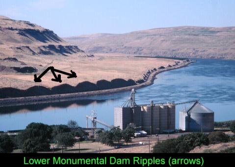
But, I'll post an example of how water better explains drumlins than ice.
And, if I missed it in my initial perusal of the thread, my apologies, but do we have any alternate water-based explanation for creating these features at the scale we find them? If so, can we find any examples where evidence exists of these features being created by water not associated with ice?
No, I have not presented my hypothesis yet. I'll post it in a separate posting.

User avatar
otseng
Savant
Posts: 20791
Joined: Thu Jan 15, 2004 1:16 pm
Location: Atlanta, GA
Has thanked: 211 times
Been thanked: 360 times
Contact:

Post #23

Post by otseng »

Below is a map of drumlin fields in the Great Lakes region.

Image
http://www.geo.msu.edu/geo333/drumlins.html

The directionality of the drumlins are indicated on the map. I would say it's more consistent with water receding into the lakes, rather than glacier movement.

It is more evident on the map of the bottom of the page. (It's too large to include here)

The red lines indicate drumlins. If a large glacier formed the drumlins, shouldn't all the dumlins be parallel to each other? And how can drumlins at the bottom left go east-west?

A more reasonable explanation is that water receded from the land into the lake and is more consistent with the direction of the drumlins.

User avatar
otseng
Savant
Posts: 20791
Joined: Thu Jan 15, 2004 1:16 pm
Location: Atlanta, GA
Has thanked: 211 times
Been thanked: 360 times
Contact:

Post #24

Post by otseng »

Image
http://freepages.genealogy.rootsweb.com ... umlin.html

If the direction of drumlins are parallel to the direction of ice flow, then how can the above be explained? In just one area, we see the direction of drumlins ranging from NW to NE.

User avatar
Goat
Site Supporter
Posts: 24999
Joined: Fri Jul 21, 2006 6:09 pm
Has thanked: 25 times
Been thanked: 207 times

Post #25

Post by Goat »

otseng wrote:Below is a map of drumlin fields in the Great Lakes region.

Image
http://www.geo.msu.edu/geo333/drumlins.html

The directionality of the drumlins are indicated on the map. I would say it's more consistent with water receding into the lakes, rather than glacier movement.

It is more evident on the map of the bottom of the page. (It's too large to include here)

The red lines indicate drumlins. If a large glacier formed the drumlins, shouldn't all the dumlins be parallel to each other? And how can drumlins at the bottom left go east-west?

A more reasonable explanation is that water receded from the land into the lake and is more consistent with the direction of the drumlins.
And what exactly do you think MADE the lakes?? From answer.com
The Great Lakes were formed approximately at the end of the Pleistocene period, when the glacier-carved lake basins were filled with meltwater from the retreating ice sheet. The lakes are connected to each other by straits, short rivers, and canals. The height above sea level of the lake surfaces varies from Lake Superior's 602 ft (183 m) to Lake Ontario's 246 ft (75 m); the greatest sudden drop occurs at Niagara Falls (167 ft/51 m) between lakes Erie and Ontario; the water levels fluctuate over the months and years due to climatic changes. All the lake bottoms, except that of Lake Erie, extend below sea level.

User avatar
otseng
Savant
Posts: 20791
Joined: Thu Jan 15, 2004 1:16 pm
Location: Atlanta, GA
Has thanked: 211 times
Been thanked: 360 times
Contact:

Post #26

Post by otseng »

Another area that has giant ripple marks is the Nebraska Sand Hills.

Image
http://en.wikipedia.org/wiki/Image:Nebr ... -hills.jpg

If you look at the above picture, it would seem like some sort of water erosion pattern. Except, this is a shot taken from space of the Nebraska Sand Hills.
The Sand Hills are a 19,600 mi² (50,960 km²) region of mixed-grass prairie in north-central Nebraska, covering just over one-fourth of the state.
http://en.wikipedia.org/wiki/Sand_Hills_%28Nebraska%29

Here are some more photos of the area:

Image
http://www.uwsp.edu/geo/projects/geoweb ... dHills.HTM

Image

From the ground, they just look like rolling hills to us.

Image

Image

User avatar
otseng
Savant
Posts: 20791
Joined: Thu Jan 15, 2004 1:16 pm
Location: Atlanta, GA
Has thanked: 211 times
Been thanked: 360 times
Contact:

Post #27

Post by otseng »

goat wrote:And what exactly do you think MADE the lakes?? From answer.com
The Great Lakes were formed approximately at the end of the Pleistocene period, when the glacier-carved lake basins were filled with meltwater from the retreating ice sheet. The lakes are connected to each other by straits, short rivers, and canals. The height above sea level of the lake surfaces varies from Lake Superior's 602 ft (183 m) to Lake Ontario's 246 ft (75 m); the greatest sudden drop occurs at Niagara Falls (167 ft/51 m) between lakes Erie and Ontario; the water levels fluctuate over the months and years due to climatic changes. All the lake bottoms, except that of Lake Erie, extend below sea level.
It seems quite ad hoc to me. Glaciers can carve out lakes and also on the shores leave drumlins. How is it able to do this?

A more simpler answer is that receding waters created the drumlins and filled the lower elevations with water to create the lakes.

User avatar
Goat
Site Supporter
Posts: 24999
Joined: Fri Jul 21, 2006 6:09 pm
Has thanked: 25 times
Been thanked: 207 times

Post #28

Post by Goat »

otseng wrote:
goat wrote:And what exactly do you think MADE the lakes?? From answer.com
The Great Lakes were formed approximately at the end of the Pleistocene period, when the glacier-carved lake basins were filled with meltwater from the retreating ice sheet. The lakes are connected to each other by straits, short rivers, and canals. The height above sea level of the lake surfaces varies from Lake Superior's 602 ft (183 m) to Lake Ontario's 246 ft (75 m); the greatest sudden drop occurs at Niagara Falls (167 ft/51 m) between lakes Erie and Ontario; the water levels fluctuate over the months and years due to climatic changes. All the lake bottoms, except that of Lake Erie, extend below sea level.
It seems quite ad hoc to me. Glaciers can carve out lakes and also on the shores leave drumlins. How is it able to do this?

A more simpler answer is that receding waters created the drumlins and filled the lower elevations with water to create the lakes.
Can you find a geological paper that would confirm this?

Or, are you just speculating. I don't have a geology degree. DO you?

User avatar
otseng
Savant
Posts: 20791
Joined: Thu Jan 15, 2004 1:16 pm
Location: Atlanta, GA
Has thanked: 211 times
Been thanked: 360 times
Contact:

Post #29

Post by otseng »

goat wrote: Or, are you just speculating. I don't have a geology degree. DO you?
Whether I have a geology degree or not is immaterial.

All I ask is an explanation of the mechanism of how a glacier is able to carve out a lake and also leave drumlins.

User avatar
Goat
Site Supporter
Posts: 24999
Joined: Fri Jul 21, 2006 6:09 pm
Has thanked: 25 times
Been thanked: 207 times

Post #30

Post by Goat »

otseng wrote:
goat wrote: Or, are you just speculating. I don't have a geology degree. DO you?
Whether I have a geology degree or not is immaterial.

All I ask is an explanation of the mechanism of how a glacier is able to carve out a lake and also leave drumlins.
When a glacier advances, it acts like a bulldozer, however, because there is a lot of pressure on the bottom of the glacier, the bottom of the glacier is very fluid.

It gouges out the lakes when it push dirt out of the way below a later water table.

There ARE lakes that have drumlins within them you know.. they are not mutually exclusive.

Post Reply