
One of the significant parts of the Creation Model (CM) is that a world-wide flood occurred. This flood covered the entire world. Naturally, many questions arise out of this:
How can a world-wide flood feasibly happen?
Where did all the water come from?
Where did all the water go?
What significance does it have on the CM?
What evidence are there of a global flood?
Global Flood
Moderator: Moderators
-
otseng

- Savant
- Posts: 20791
- Joined: Thu Jan 15, 2004 1:16 pm
- Location: Atlanta, GA
- Has thanked: 211 times
- Been thanked: 360 times
- Contact:
Post #81
Jose wrote:I'd imagined that the settling would have occurred well after the water was ejected. Say, over the course of 40 days and nights. After that, it should all be sedimentation, eventually followed by erosion as the water went somewhere. How long did it take before the water was back to "normal"? I dont' have a clue.
Let me go into a little more detail about the timing of events.
There are 4 major phases of the flood: the rupture phase, the flood phase, the continental drift phase, and the recovery phase.

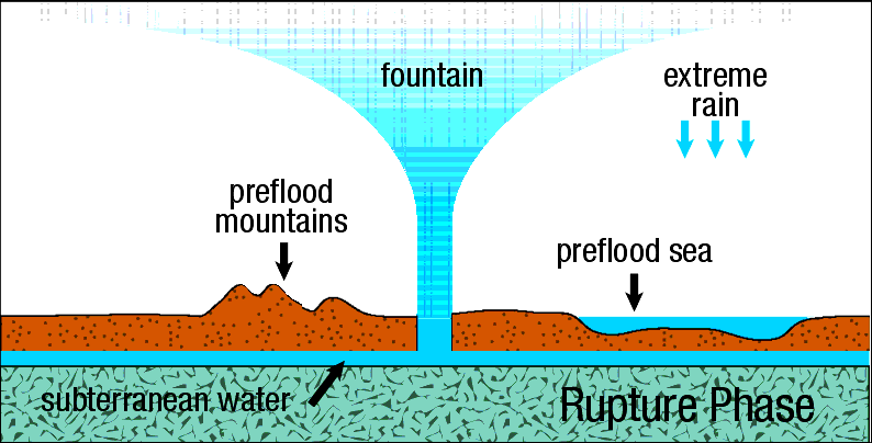
During the rupture phase, the crack on the crust formed that started at the mid-Oceanic ridge and traveled around the world. Water jettisoned from the underground chamber at the fissures into the atmosphere and eroded the sides of the cracks. I believe this phase occurred over days, perhaps weeks. Brown says this occurred in hours. I however think it must've been longer. I think the layers got deposited in stages to account for footprints in layers and also sequences of layers that could not be explained with a single deposit of sediments. Sorting of layers would take place between the stages where deposits were laid down. This entire process could not have happened in hours, but rather over many days.
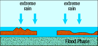
During the flood phase, sediments and water covered the entire earth. The surface topography was still relatively flat at this point. Brown says this phase lasted months long. I would say this probably last much shorter, in the range of days/weeks. My basis for this is that I don't agree with Brown on how the mid-Oceanic ridge got formed. Brown believes it was formed by the weight of the continents pressing down on the basalt and it eventually caused the mid-Oceanic ridge to form. I have a different hypothesis. I believe the oceanic ridges were caused by hydrodynamic forces as the water was ejected out of the earth. The pressure of the escaping water would cause the basalt to be forced upward by the water pressure forces and form the ridges. The formation of the ridges caused the flood to go into the next stage, the drift phase. Since hydrodynamic forces would have immediately formed the ridges, the flood phase could not last too long.
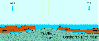
During the drift phase, as the mid-Oceanic ridge formed, the hydoplates slid down the ridge and the Americas and Eurasia/Africa moved away from each other. As the hydoplates moved, there was still some underground water under the hydroplates to allow for movement. But, when the water was gone, the hydroplates would stop moving when it hit the basalt underneath. The momentum of the moving hydoplates would cause the formation of the mountains. Brown believes this phase to have lasted 1 day, though I believed it lasted much longer, days/weeks.
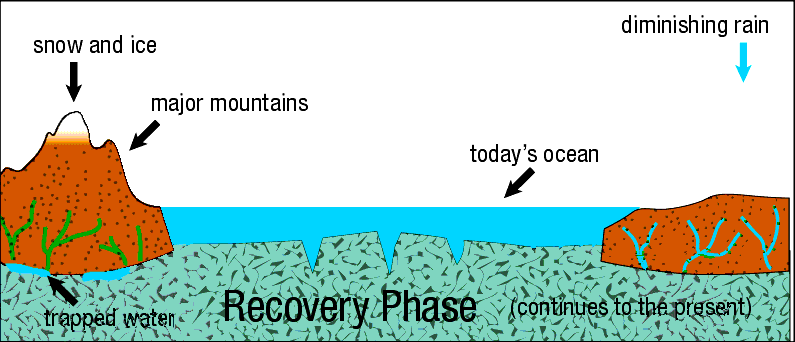
During the recovery phase, the water receded into the lower parts of the surface creating the oceans we have now. Canyons were created by water rapidly receding from the areas near mountains. The sea level was lower after all the water receded than compared to now. Over time, all the weight of the continents would cause the continents to gradually sink into the basalt underneath. This would cause the continents to be lowered, as well as push the sea floor up. This would explain land bridges in the past that are now covered by water today.
Still, the ocean ridges may be special. We might need to think about the Pacific ocean, where there isn't a ridge, rather than the Atlantic, where there is. The Pacific ought to be pretty deep with sediment, since it's had the flood and some 6000 years of current-rate sedimentation to add to it.
I have simplified the explanation of the cracks on the crust by only mentioning the mid-Atlantic ridge. The mid-Atlantic crack was where the fissure originally started. But, it did not stop there. Anywhere where there is a ridge in the oceans was where there was a fissure in the crust.
There are actually many ridges in the Pacific Ocean. As evidenced below, ridges are found in almost all the oceans.
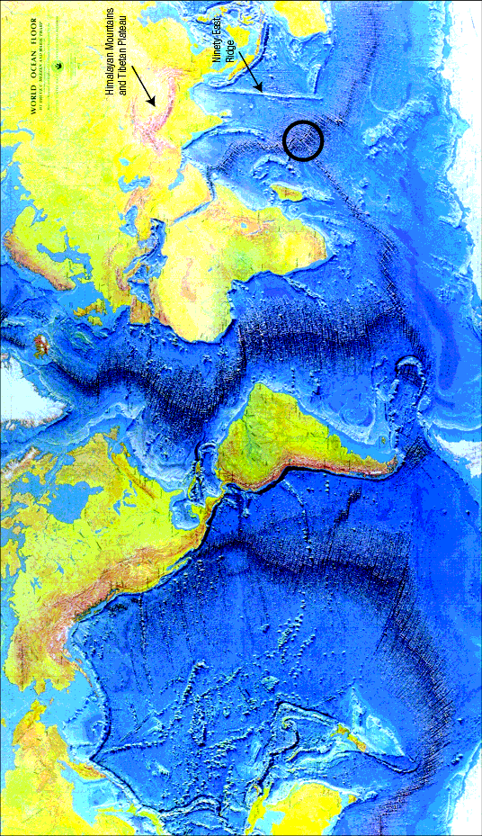
It is also interesting to note that almost all the ocean floors are basalt. To my knowledge, there are not layers of sediments covering the sea floors.
The question, then, is "how many stages"?
I think it would depend on the location. Not all places would get deposits at the same time or even the same frequency. Some locations could get few stages whereas some others could get many stages.
I think you are agreeing. The layers formed prior to the waters receding. Therefore, the layers were all underwater until the waters receded. Therefore, land animals would have been unable to walk on them and create footprints. This seems to me to make sense, if the flood killed the land animals. They'd make lousy footprints after that.
I think I might be agreeing. I hope my explanation above explains my thoughts on the entire process.

Post #82
So, there is a discrepancy between your model and Brown's model, in that the ocean ridges are proposed to have formed at different times and for different reasons. This is interesting. It gives us two different hypotheses that make two different sets of predictions. To do this scientifically, we need to choose one hypothesis to examine at a time. Which shall we use?
But, in either model, yours or Brown's, it seems to be the case that the movement has stopped. This, too, provides a testable prediction: the plates should no longer be moving, and the oceanic ridges should no longer be causing further spreading of the ocean floor. Continued movement would be in conflict with the predictions. Do you agree?
There is also another prediction that is clear: all sea floor rock should be of the same ages.
This difference in timing does not, I think, affect the predictions of the models. In any case, the difference between 1 day and several weeks is much less than the difference between these times and, say, a billion years.otseng wrote:The momentum of the moving hydoplates would cause the formation of the mountains. Brown believes this phase to have lasted 1 day, though I believed it lasted much longer, days/weeks.
But, in either model, yours or Brown's, it seems to be the case that the movement has stopped. This, too, provides a testable prediction: the plates should no longer be moving, and the oceanic ridges should no longer be causing further spreading of the ocean floor. Continued movement would be in conflict with the predictions. Do you agree?
My error. To be more precise, I'll phrase it as the "north Pacific." Certainly, at the contact of the Pacific Plate with the Antarctic Plate and the Nazca Plate there is a ridge. Let me rephrase my prediction, and state that the north Pacific should be deep with sediment. Even in Brown's model, it lacks a ridge, and therefore didn't allow the continents to slip off it. Rather, this is where Asia and North America went when they slipped off the Atlantic sea floor. This part of the ocean seems to be relatively undisturbed by the proposed movements, and should have been the lowest spot that sediments could have accumulated. The prediction is clear: there should be plenty of sediment.otseng wrote:There are actually many ridges in the Pacific Ocean. As evidenced below, ridges are found in almost all the oceans.
There is also another prediction that is clear: all sea floor rock should be of the same ages.
We'll need to be explicit here, or the hypothesis becomes too vague to be scientific. Where would we find "few stages" and where would we find "many stages"? And, how many is "many"? Is it like counting in trollish, one, two, many? Or is it "between 4 and 10"? Or is it hundreds or thousands? A good model is precise.otseng wrote:I think it would depend on the location. Not all places would get deposits at the same time or even the same frequency. Some locations could get few stages whereas some others could get many stages.Jose wrote:The question, then, is "how many stages"?
Post #83
I read somewhere (arrgggh, trying to remember) that continental drift is occurring - constantly - at a measurable rate which is roughly equal to the rate at which your fingernails grow. I found this to be a fascinating statistic. Every time clip my nails, I think about it!jose wrote: But, in either model, yours or Brown's, it seems to be the case that the movement has stopped. This, too, provides a testable prediction: the plates should no longer be moving, and the oceanic ridges should no longer be causing further spreading of the ocean floor. Continued movement would be in conflict with the predictions. Do you agree?
"When I give food to the poor, they call me a saint. When I ask why the poor have no food, they call me a communist."
Post #84
yeah...the US and Europe are moving away from each other at about 4cm per year. We've also measured the rate of movement along the San Andreas (I used to live within it's danger zone, so I payed attention), which is about the same. It goes in spurts, though, as pressure from plate movement finally overcomes friction between plates, and we get earthquakes. Hmmm...I wonder if fingernails do the same kind of thing, but the "quakes" are just a lot smaller....I read somewhere (arrgggh, trying to remember) that continental drift is occurring - constantly - at a measurable rate which is roughly equal to the rate at which your fingernails grow. I found this to be a fascinating statistic. Every time clip my nails, I think about it!
-
otseng
- Savant
- Posts: 20791
- Joined: Thu Jan 15, 2004 1:16 pm
- Location: Atlanta, GA
- Has thanked: 211 times
- Been thanked: 360 times
- Contact:
Post #85
I guess we can discuss mine first since that's the one I'm espousing.Jose wrote:To do this scientifically, we need to choose one hypothesis to examine at a time. Which shall we use?
Movement has stopped based on hydoplate. However, I would not think that other sources of movement would necessarily be discounted.otseng wrote: But, in either model, yours or Brown's, it seems to be the case that the movement has stopped.
I see your point. And I have not read in Brown's hypothesis on an explanation of this. So, I cannot give an explanation at this time. I would say based on the current proposal of the hypothesis, your predictions would stand.This part of the ocean seems to be relatively undisturbed by the proposed movements, and should have been the lowest spot that sediments could have accumulated. The prediction is clear: there should be plenty of sediment.
I would extend this and say that all rocks should be of the same age.There is also another prediction that is clear: all sea floor rock should be of the same ages.
I will have to admit to vagueness here. The multiple stage hypothesis is one that I came up with. My knowledge of geology is limited to be able to fully present a scientific case for my multiple stage hypothesis.We'll need to be explicit here, or the hypothesis becomes too vague to be scientific. Where would we find "few stages" and where would we find "many stages"? And, how many is "many"? Is it like counting in trollish, one, two, many? Or is it "between 4 and 10"? Or is it hundreds or thousands? A good model is precise.

Post #86
Except volcanic rocks from recent eruptions, yes? This should include magma rising from the sea floor and cooling to basalt.otseng wrote:I would extend this and say that all rocks should be of the same age.jose wrote:There is also another prediction that is clear: all sea floor rock should be of the same ages.
Post #87
Great. We'll look at the predictions of your current hypothesis, and then reassess where we stand, once we have done so.otseng wrote:I see your point. And I have not read in Brown's hypothesis on an explanation of this. So, I cannot give an explanation at this time. I would say based on the current proposal of the hypothesis, your predictions would stand.Jose wrote:This part of the ocean seems to be relatively undisturbed by the proposed movements, and should have been the lowest spot that sediments could have accumulated. The prediction is clear: there should be plenty of sediment.
You're right. Thank you.ST88 wrote:Except volcanic rocks from recent eruptions, yes? This should include magma rising from the sea floor and cooling to basalt.otseng wrote:I would extend this and say that all rocks should be of the same age.Jose wrote:There is also another prediction that is clear: all sea floor rock should be of the same ages.
To osteng
Post #88Gidday otseng,
I have been reading and watching the discussion between yourself and others on this thread. I also understand that you wish to restrict argument to your model of the Flood, simply because to bring in other ideas would endlessly expand the topics under discussion.
However, all models must be grounded in reality. I mean, it is one thing to build up a model for the Flood, but if the records show that no such thing occurred, then why attempt to model the Flood in the first place. (By Flood, I mean that event recorded in Genesis 6,7 and 8 and was, by the reckoning of most YECs, a global event.)
In what follows I assume that you are a YEC – correct me if I am wrong. My critique will be somewhat unbalanced in that I shall pick on only a few points I noticed in passing. As a creationist, you probably will take exception to my statement that the records show that no such thing as the Flood occurred. Consider this:-
1) We can drill ice cores in places like Greenland (1), which span the last 110,000 years, and Antarctica (2), which span the last 740,000 years and
2) We can observe extensive geologic strata which show a range of differing environments spanning back tens of thousands through to millions to billions of years.
WITH RESPECT TO THE ICE CORES
With these ice cores and/or other similar cores, we can see various historical and natural phenomena which correlate with other independent records (historical, geological, botanical etc.) At no stage in these ice cores do we see evidence of a major flood that covered both hemispheres at the one time – a mere 4500 years ago.
If you think otherwise then can you point out where any YEC scientist has reliably identified such an event in these cores?
I am aware of one YEC scientist attempting to discredit the interpretation placed on the Greenland ice cores (3). However Oard’s article is replete with:-
Hedging and shifting goal posts (4)
The proxies for ice bands are perfectly reasonable as the relevant literature explains. Oard considers the upper bands as indicating real annual events but those of lower layers as no more than oscillations in signals within annual band. Oard is shifting his interpretations here in order to suit himself. He offers no sensible reasons for the shift in interpretation. His personal reason is obvious though - he has to fit the data to his theory.
Just so stories, handwaving and bluff
His choice of language betrays an admission of lack of evidence for his own ideas. Even though his description of NS (naturalistic science) is filled with words like "assume", "believe", "assumptions", "interpretations" and "think", similar words are missing from his CS (creation science) descriptions. What does he offer in return? "Would have", "would generally be..." etc. His dismissal of the conventional interpretation of the GISP2 cores is mere handwaving. His own theory is just-so-story. Read the papers that Oard cites and you will understand this. Furthermore many of his statements about precipitation, temperatures, elevations etc are lifted out of context from cited NS articles or are no more than assumptions on Oard's behalf. Therefore they constitute just-so-stories. They are conveniences to fit Oard's model. No more. The NS proxies for core layers - isotopes, conductivity's, scattering etc. are excellent proxies for annual layers with a basis in physics and observation, as the literature explains only too well. Oard's graph comparing CS and NS annual ice layer thickness is again a just so story. The NS graph is based on observation and well understood physics. The CS graph, because it is based on so many assumptions with little link to observation is really just one of many (conflicting) CS graphs that could be drawn for comparison. Practitioners of NS are not as blind to problems as Oard implies. Woodmorappe's article on "inflated C14 dates" shows how NS so readily challenges and corrects its own assumptions. However, Woodmorappe, like other creationists, seems unable to understand this. Such corrections are seen as a failure of the system, rather than a necessary improvement of it.
Omission, silence
Oard, in offering his reinterpretation is very silent on the reasons why NS considers that 100,000 layers were legitimately counted and that these layers represent annual events. The cited papers answer all of Oard's problems. Taking note of these however would not allow Oard his reinterpretation. Oard is also silent on the fact that under-counting has almost certainly occurred. (Given Oard's cavalier attitude towards evidence, think about the consequences of under-counting!) Oard is silent on the markers that allow NS to tie the lower levels in with global events that are reasonably well dated by independent means. He is silent on the cross matching and correlations of band counts. Basically Oard is very silent on numerous points raised in the cited papers that really show his theory to be a muddle.
Given that the Flood does not show up in these cores and that at least one YEC scientists cannot credibly criticize the interpretations placed on these cores (can you point me to any credible criticisms?), then:-
1) Why attempt to model something that probably did not occur?
2) What physical evidence do you use to constrain your models with?
WITH RESPECT TO EXTENSIVE GEOLOGICAL STRATA
I thought I saw, somewhere in this thread, you make the claim that all rocks were laid down at the time of the Flood. Certainly you claim that all rocks would be of the same age (see below).
Yet world wide we see very deep geological strata that reveal a range of environments over very extensive periods of time.
In none of these layers do we see evidence of the Flood some 4,500 years ago. If I am wrong, can you point me to such evidence?
Consider the following however. Go to the geological literature and examine the stratigraphic columns which are often published (5), (6), (7), (8.),(9) and (10),.
In (5) you will see columns which show up to 20m of different layers comprised of marl, silcrete, cross bedding, various grades of sand, pebbles, boulders, ripples (in cross strarification). These strata do no come in any particular (sorted) order and can occur in several places through the column.
In (6) you will see columns from 1km to 5km thick comprising of layers which are interpreted as alluvial plains, open lacustrine, wave rippled shorelines, alluvial plains, floodplains, alluvial plains with channels etc. The associated climates appear to vary from hot and seasonally dry to warm and humid to warm as seasonally dry. Much of the strata are uncomformable. As with the Cypress Hills strata (above), these layers and seasonal associations repeat throughout the column.
In (7) you will see columns some 80m in depth with interspersed strata of cross bedding, concretions, mudrocks, ripple surfaces, beds with burrows, etc.
In (8.) you will see a column of some 30m comprising of layers of packstones, marls/shales, bioclastic packstones in clays, silts or various sands – depending on the depositional and weathering environment etc. Not only this, the authors detail the distribution of planktonic foraminifera and palynomorphs. These fossils are not scattered uniformly throughout the column. Rather they are found in specific layers. The element iridium is not found uniformly through the column either. Rather it spikes at one particular location in the column in a layer of packstone. But this packstone also occurs elsewhere in the column – with no iridium spike.
Given that the geologic literature is replete with this kind of information, why is no particular layer declared to be the Flood layer? If all layers were put down by the Flood at the one time then how do you explain these distributions in dates, fossils, depositional environments, layerings etc?
In (9), figure 9.7 you will see a picture of the Great Unconformity in the Grand Canyon. It consists of a massive angular unconformity overlain by horizontal sandstones and underlain by folded shales. If all rocks were deposited at the time of the Flood, a mere 4,500 years ago, how do you explain such massive structures. That is, how does an angular unconformity manage to sit between folded shales and thick horizontal sandstones?
In (10) you will see columns showing some 700m of various strata of tufts, clays, silts, sands, basalts, erosional contacts, carbonate concretions etc. Molluscs predominate in some strata, Ostracods in others, and diatomites in others yet again. How do you derive these layers of differing depositional environments interspersed with tufts and erosional contacts as a by-product of the Flood?
In all of this, how do you differentiate rocks that were created 6,000 years ago from rocks formed by the Flood? Or were they all formed in the Flood and none at creation? If so, then how do you know this?
YOUR MODEL – Constrained by anything?
I noted that you offered a model of your version of the Flood. (Good on you by the way - sticking your head above the parapets.) I have huge problems with it. Certainly it is constrained in the sense that it relies on what we observe in a broad sense – ie mid ocean ridges, subduction, hills, erosional features etc. However you could use these features to explain anything you wish. In mainstream science, models have to be constrained by things such as dates, possible/observed rates of change, chemical compositions etc.
Let me provide some examples:-
On 30-Sep-2004, in the posting where you supplied your model, you wrote:-
Otseng:- It is also interesting to note that almost all the ocean floors are basalt. To my knowledge, there are not layers of sediments covering the sea floors.
Well the ocean floors are basalt. You are correct there. However you are not correct when you say that there are “not layers of sediment covering the sea floors”. A quick check of a book on oceanography which deals with sea floor sedimentation would have shown you this (11). Figure 4-11 of reference (11) shows a seismic reflection profile off Nova Scotia. There the basaltic oceanic crust is overlain by some 40m thick sediments of turbidite beds. A major part of the chapter 4 of reference (11) concerns itself with deep sea sedimentation and Figure 4-20 shows how sediment thickness increases with distance from the mid ocean ridge of the Atlantic. At the ridge, sediment thickness is 0m. 1600km from the ridge, it is about 180m.
Ditto the Pacific. Figure 4-21 of (11) shows sedimentation across that ocean from the East Pacific Rise, where basalt is exposed to the trench on the eastern flank of Japan, a few thousand km away. At the trench the basaltic floor is well covered by calcareous ooze then deep sea clays then calcareous-siliceous oozes then more deep sea clays then finally volcanic type sediments.
This is what I mean about unconstrained modeling. If you ignore what is known, then of course you can say such things as “all rocks are or the same age” and “there are no sediments on the basalt floor of the oceans”.
However, one look at the actual data and this part of your model becomes suspect – all for the want of a quick check in a relevant text book!
Another example:-
You disagree with Brown (and Brown with you) but you both appear to argue with no constraining data. On what basis can either of you argue for the better model?
For example you write about the drift phase:-
During the drift phase, as the mid-Oceanic ridge formed, the hydoplates slid down the ridge and the Americas and Eurasia/Africa moved away from each other. As the hydoplates moved, there was still some underground water under the hydroplates to allow for movement. But, when the water was gone, the hydroplates would stop moving when it hit the basalt underneath. The momentum of the moving hydoplates would cause the formation of the mountains. Brown believes this phase to have lasted 1 day, though I believed it lasted much longer, days/weeks.
The real/actual evidence is that the (South) Atlantic began to form 120 million years ago. Such timing accommodates observed rates of sea floor spreading of a few cm per year today.
If I understand your model correctly, this break up began only 4,500 years ago followed by a horizontal continental movement of some 1500km which occurred in day’s/weeks.
First of all, do either you or Brown have any evidence that the Atlantic began to break up 4,500 years ago – or whenever you think it did begin to fracture? Do you have any evidence for this massive amount of underground water that allows the continents to slip and slide so well – or is this water just a convenience, introduced to do the job you require? Water is normally found underground in the pores of rocks yet here you seem to suggest that it made a surface upon which the continents could slide. But this is pure speculation on your part is it not?
If these water deposits really existed then why have the continents spreading at a mere(?) 10+ km a day for a few weeks. Why is Brown not correct and the continents did not zip around in one day, and cover 1500 km? Why are you both not wrong and the continents zipped around in a couple of hours? Neither of you have any observational evidence upon which to base your speculations. Nothing is constrained within your models. (Well I’ll bet my false teeth on that one anyway!)
In all of this, there is no evidence of sediments that could be said to have derived from a global flood which occurred 4,500 years ago.
If you believe otherwise then please inform me!
Yet other examples:-
I noted in your block diagram a series of events laid out in the various phases. Thus in the rupture phase you have meteor impacts, fossil beds being laid down, mammoths frozen; in the post recovery phase, you have oceanic trenches forming, canyons forming etc.
For any of this do you have reliable dates – for one event even? I mean why do you put the meteors where they are and the canyon formations where they are? You really have no constraining dates for any of this do you? The only constraint you have is that you take the “Flood” as gospel and everything must fit into that.
But given that you claim that we are unable to date things, how can you really put the events into the positions you do?
AGES OF ROCKS AND PREDICTIONS
On 2-Oct-04, in response to Jose’s :-
There is also another prediction that is clear: all sea floor rock should be of the same ages.
you wrote:-
Otseng:- I would extend this and say that all rocks should be of the same age.
Do you have evidence for any of this or are your predictions somewhat vacuous? I mean we can date the ocean floor basalts and dates range from 0 years at the mid ocean ridges to a maximum of 200 million years at continental margins. On the continents, rocks date from 0 age to a maximum of 4 billion years.
To predict that all rocks are of the same age is a bit like denying the existence of sediments on top of the oceanic crust. You can argue that way – if you ignore the data.
Do you have any evidence to support your claim that all rocks are of the same age - 4,500 years? Are you arguing that none were created 6,000 years ago? If some were created then how do you distinguish such rocks from those that were formed at the Flood (from consolidating sediments)?
Unless you have any chance of doing this, whence your prediction?
Regards, Roland
REFERENCES
(1) Meese, D.A., Gow, A.J., Alley, R.B., Zielinski, G.A., Grootes, P.M., Ram, M., Taylor, K.C., Mayewski, P.A., and Bolzan J.F. “The Greenland Ice Sheet Project 2 depth-age scale: Methods and results. Journal of Geophysical Research, 102, 30 Nov 1997, pp 26411.
(2) “Eight glacial cycles from an Antarctic ice core”, Nature 429 10 June 2004, pp 623. For the list of authors – refer to the end of the paper.
(3) Oard, Michael J, "Do Greenland ice cores show over one hundred thousand years of annual layers?" in "Countering the critics" TJ, 15(3) p 39-42
(4) The following points are taken from a letter I wrote in March 2002 to Dr Tas Walker (AiG Australia) in response to a letter of his sent in January of that year.
(5) Leckie, D.A. and Cheel, R. J., “The Cypress Hills Formation (Upper Eocine to Miocene): a semi-arid braidplain deposit resulting from intrusive uplift”, Canadian Journal of Earth Sciences 26, 1989, pp1918.
(6) Eberth, David A., Birnkman, Donald B., Chen Pei_Ji, Feng-Tian Yuan, Wu Shao-Zu, Li Gang, Cheng Xian-Shen, “Sequence stratigraphy, paleoclimate patterns, and vertebrate fossil preservation in Jurassic-Cretaceous strata of the Junggar Basin, Xinjiang Autonomous Region, People’s Republic of China”, Canadian Journal of Earth Sciences 38 1627-1644, 2001.
(7) Smith, Roger M.H and Ward, Peter D., “Pattern of vertebrate extinctions across an event at the Permian-Triassic boundary in the Karoo Basin of South Africa”, Geology, December 2001, pp 1147.
(8.) Albertao, Giberto A., Koutsoukos, Eduardo A.M., Regali, Marilla P.S., Attrep Jr., Moses, Martins Jr., Paulo P., “The Cretaceous-Tertiary boundary in southern low-latitude regions: preliminary study in Pernambuco, northeastern Brazil. Terra Nova 6 pp 366, 1994
(9) Press, Frank and Siever, “Understanding the Earth”, W.H. Freeman and Company, New York, 2001.
(10) Brown, F.H. and Feibel, C.S., “Stratigraphy, Depositional Environments, and Palaeogeography of the Koobi Fora Region.” (This was a section of a book the name of which I cannot locate.)
(11) Pinet, Paul R. “Oceanography: An Introduction to the Planet Oceanus.”, West Publishing Company, St Paul, 1992.
-
otseng
- Savant
- Posts: 20791
- Joined: Thu Jan 15, 2004 1:16 pm
- Location: Atlanta, GA
- Has thanked: 211 times
- Been thanked: 360 times
- Contact:
Re: To osteng
Post #89Welcome to the forum and to the debate.
I will have to plead scientific ignorance to many of the questions you posed. My expertise is certainly in none of the areas I have touched on in this thread. I only approach it from a layman's perspective, so I am not able to treat this topic with the utmost scientific rigor. However, if you are willing to be patient with a layman's perspective, I will try to answer questions to the best of my ability.
I will have to plead scientific ignorance to many of the questions you posed. My expertise is certainly in none of the areas I have touched on in this thread. I only approach it from a layman's perspective, so I am not able to treat this topic with the utmost scientific rigor. However, if you are willing to be patient with a layman's perspective, I will try to answer questions to the best of my ability.
It depends on which clock one uses. But, yes, in general I would be classified as a YEC.rjw wrote: In what follows I assume that you are a YEC – correct me if I am wrong.
Thank you for the clarification. I did not do any research on the sediments found on the ocean floors. I stand corrected that there exists sediments on the sea floors.rjw wrote: However you are not correct when you say that there are “not layers of sediment covering the sea floors”. A quick check of a book on oceanography which deals with sea floor sedimentation would have shown you this (11). Figure 4-11 of reference (11) shows a seismic reflection profile off Nova Scotia. There the basaltic oceanic crust is overlain by some 40m thick sediments of turbidite beds. A major part of the chapter 4 of reference (11) concerns itself with deep sea sedimentation and Figure 4-20 shows how sediment thickness increases with distance from the mid ocean ridge of the Atlantic. At the ridge, sediment thickness is 0m. 1600km from the ridge, it is about 180m.
To otseng
Post #90Hello otseng,
Thank you for your welcome.
I did seek clarification on your perspective since there was the possibility that you were an OEC – hence dating strata would not be the problem that it is for a YEC.
With respect to you being a layman – no problems. I am one too. However I do come to this debate with the perspective of an ex-Christian (i.e. now a sympathetic atheist) who embraces the mainstream with respect to science, philosophy and most other things. Because of my background I retain a strong interest in theology.
Regards, Roland
