
Several years ago (more then one, less then ten thousand) the idea that the Earth was not the center of the Universe was high in the ranks of things we argued about. Neatly behind that would be the age of the Universe, age of the Earth, the Earth goes around the sun, Earth is flat, etc. In time, a number of these ideas were accepted by pretty much everyone. By that I mean that I doubt even YEC will argue the point that the Earth is the center of the Universe and in addition to being flat also has the sun and everything else revolve around it.
On that line of thinking, I'd like to ask what you think of plate tectonics in that regard. It isn't brought up much on these boards, but because it neatly explains how we get fossils and strata on opposite sides of the Ocean all neatly lined up (such as the shore between Africa and South America), I imagine there must be some controversy surrounding it.
So, plate tectonics, is it like the Earth being round, or closer to evolution in terms of the amount of public debate surrounding it?
Plate Techtonics!
Moderator: Moderators
Plate Techtonics!
Post #1"Secular schools can never be tolerated because such schools have no religious instruction, and a general moral instruction without a religious foundation is built on air...we need believing people."
[Adolf Hitler, April 26, 1933]
[Adolf Hitler, April 26, 1933]

Post #101
These are good points. One explanation might be that, with respect to North American for example, that the westward movement relfected by the ocean ridges occurred over a long period in the past while the vector diagram is showing the current movement. I don't know what mechanisms or forces could cause a "change in direction" like this, but it seems to me to be at least plausible, especially if the change happened gradually over a long period.Otseng wrote:As you stated, the "North America is rotating about a point somewhere near the Yucutan Peninsula". This movement would indicate that it did not move due west from the mid-Atlantic ridge.
South America is generally moving north from GPS data. So, this is in contrast to it having moved due west.
Europe and Africa are moving northeast. Yet the coast of Europe/Africa matches the mid-Atlantic ridge only if it moved due east.
Also, I have pointed out that the velocities of the continental movement does not match the rate of growth of the ridges in several places.
All these factors together (plus others) shows to me that there is no correlation between ridge growth and continental movement.
Granted, a plate would have a tremendous amount of mass, and so changing its direction would require a LOT of force, but if the motions are at very small velocities and the forces applied over long periods of time, it should be possible. If the force is applied by convection currents in the mantle, this would certainly involve huge amounts of mass moving below the crust.

Post #102
Looking at the ocean floor map wouldn't tell you much about past movements. It might tell you in general where the pressure is coming from and where the boundaries are, but it wouldn't reliably show how a plate would (or did) move.otseng wrote:Looking at the map of the ocean floor, it appears that the Americas moved due west. Not much (if any) rotations are evident from the ocean floor map.
I think you're making the assumption that plate tectonics dictates that all of the continents must move exactly according to where the Mid-Atlantic ridge is now. Be assured that this is not the only force working on these continents. Not only are they working on each other also, but they are subject to numerous other forces. Also, please note that the speed of movements are not necessarily stable over time.otseng wrote:As you stated, the "North America is rotating about a point somewhere near the Yucutan Peninsula". This movement would indicate that it did not move due west from the mid-Atlantic ridge.
South America is generally moving north from GPS data. So, this is in contrast to it having moved due west.
Europe and Africa are moving northeast. Yet the coast of Europe/Africa matches the mid-Atlantic ridge only if it moved due east.
Also, I have pointed out that the velocities of the continental movement does not match the rate of growth of the ridges in several places.
All these factors together (plus others) shows to me that there is no correlation between ridge growth and continental movement.
Perhaps you missed my post on the forces around South America:
http://www.debatingchristianity.com/for ... 0514#20514
The movements of the continents are not smooth, nor are they straight or even reliably dictated by the surface pressures we are able to observe. The Mid-Atlantic ridge is just one factor in continental movement.
Post #103
There may be another misconception about the Mid-Atlantic ridge, and about divergent boundaries in general. It's not a single continuous event. Instead, it's a process of compression and expansion:

This diagram shows the push-pull paradigm as perhaps continuous. I don't know that I buy the extreme "pull" hypothesis just because it would seem to be much easier for the plate to shatter than it would be for it to allow itself to be pulled by the gravity of just one end. On the other hand, if it were to be pushed and pulled, it would make more sense for it to move and still remain intact.
Also, these questions are by no means settled. For example, are these continents being pulled apart by subduction, or are they being pushed apart by seafloor spreading?When two plates are pulled apart, the crust at the plate boundary is stretched and thinned. This thinning causes upwelling of underlying mantle and — more importantly — pressure release because of the reduced weight of crust on the underlying mantle.
Pressure release triggers melting in the mantle. Recall that rocks that are already near their melting point can be melted in three ways: by additional heating, by adding water, or by reducing pressure.
Pressure release triggers partial melting of the mantle: it is enough to melt minerals that have low melting temperatures, but not enough to melt all of the minerals. The resulting basaltic magma is different in composition from the mantle rocks.
Melting causes expansion, which lowers density, so the resulting magma is less dense than the surrounding rock and therefore rises into cracks in the overlying rock. Eventually it erupts, forming new oceanic crust that is made of basalts.
The sequence of events triggered by plate separation is summarized in the following figure:
Note that this figure starts by rifting or splitting of continental crust, but the same sequence of events occurs when oceanic crust is split. Indeed, the same sequence of events occurs continuously, with the splitting always occurring at the site of recent crustal formation because that is where crust is thinnest and hottest, therefore weakest.
Rifting of a continent begins by crustal stretching, which creates a long linear valley. Usually lakes occupy this valley because rain falling within the valley cannot escape in rivers to the ocean, just as most Utah rivers are trapped in the valleys and drain into lakes. This is the case in the East African rift valley, where Africa is today undergoing incipient breakup into what will eventually be two plates separated by an ocean. Today, this rift valley contains several huge lakes. The East African rift, like other rifting continents, contains abundant volcanoes because of upwelling magma; Mt. Kilamanjaro is an example.
About 70 million years ago, rifting began to separate North America and Europe, along a rift that is now the northern part of the Mid-Atlantic Ridge.
Plate Motions

Until the 1990s, prevailing explanations about what drives plate tectonics have emphasized mantle convection, and most earth scientists believed that seafloor spreading was the primary mechanism. Cold, denser material convects downward and hotter, lighter material rises because of gravity; this movement of material is an essential part of convection. In addition to the convective forces, some geologists argue that the intrusion of magma into the spreading ridge provides an additional force (called "ridge push") to propel and maintain plate movement. Thus, subduction processes are considered to be secondary, a logical but largely passive consequence of seafloor spreading. In recent years however, the tide has turned. Most scientists now favor the notion that forces associated with subduction are more important than seafloor spreading. Professor Seiya Uyeda (Tokai University, Japan), a world-renowned expert in plate tectonics, concluded in his keynote address at a major scientific conference on subduction processes in June 1994 that "subduction . . . plays a more fundamental role than seafloor spreading in shaping the earth's surface features" and "running the plate tectonic machinery." The gravity-controlled sinking of a cold, denser oceanic slab into the subduction zone (called "slab pull") -- dragging the rest of the plate along with it -- is now considered to be the driving force of plate tectonics.
Some Unanswered Questions: What Drives the Plates?
This diagram shows the push-pull paradigm as perhaps continuous. I don't know that I buy the extreme "pull" hypothesis just because it would seem to be much easier for the plate to shatter than it would be for it to allow itself to be pulled by the gravity of just one end. On the other hand, if it were to be pushed and pulled, it would make more sense for it to move and still remain intact.

Post #104
Well, let's see here...as I understand it, if you tow a magnetic recording device behind a ship, on a long string so it's pretty low, you can measure "anomalies" in the magnetic field. You get pictures like these:otseng wrote:There is not enough information here for me to make any constructive comments. Data missing includes where the measurements were taken and measurement data.

Along the Juan de Fuca Ridge, off the coast of Calif/Oregon/Washington

A really big view of the Arctic and the N. Atlantic
The color-coding helps us see the patterns of reversals, which they have matched with other measurements of age. In the upper picture, it's pretty easy to see symmetry around the spreading center, albeit offset here and there by faults. In the lower picture, we get a more confusing image. It's pretty symmetrical around Iceland and just south of it, but in the Arctic itself it's rather mottled than striped. The geology of the Arctic Ocean seafloor is not the same as the major Ridges.
Apparently, a lot of people have sailed back and forth in boats trailing magnetic detectors, because the data are pretty extensive.
The Africa/Madagascar issue isn't too severe, since the map indicates a km or two of sediment, and it's not a region at the mouth of a river (a sediment-producer). For the Pacific, we have a puzzle. It's a puzzle whether we consider tectonics or the flood, since the flood model proposes that the Pacific was not one of the places that the continents were pushed apart by water erupting from the deeps (ie the Ridges). It should have been the lowest, most stable part of the earth, and should have accumulated the most sediment. So, what can we say about it's low sediment load, in the face of the tectonic model?otseng wrote:I took a further look and noticed even more discrepencies. All throughout the western part of the Pacific Ocean is supposedly old crust. Yet, there are not the huge sediment deposits that we should expect to see if it really is that old. Also, the area between Africa and Madagascar is old, but there is not a huge amount of sediments.
We've covered one point--the subduction zones. If sediment falls into these zones, it gets swallowed up as the continents ride over it. I think that adequately explains the western side of the Pacific. For the eastern side, we don't have an active subduction zone. Rather, we have some separation, as Baja is ripped away from North America along the San Andreas. However, we infer from additional data that several plates assembled onto North America, creating California, and that the Sierras and coastal ranges were formed by traditional subduction/orogeny which has now ceased. From this historical view, we could say that sediment near the coast of N. America may have previously been eaten by the subduction zone that is no longer there.
Not a satisfactory answer? It might be if we had all of the data to support my simple-minded description of the events of the past. Without that data, you are justified in taking my explanation skeptically.
In the meantime, we have the vast ocean basin to consider. It's old, but has little sediment, just as you say. Well...what generates sediment? As you've suggested, some bumping and grinding of plates will do so. But, much of this will end up in the subduction zones, and get eaten. Otherwise--and this is particularly true of soft sediment, above the "acoustic basement" in the sediment measurements--sediment is produced by erosional runoff from the continents. We see lots of sediment at the mouths of rivers--the Mississippi, the Amazon, etc. It gets spread up and down the coasts of the continents if there's enough wave action, so this probably accounts for the "greenish haze" around the continents that we see in the sediment map. BUT, it's hard to spread the sediment out very far from the continents without strong currents to drag it there. After all, it's sediment, and sediments out onto the bottom.
Speaking of currents, what I was interested in, in an earlier post, was the "plume" of sediment streaking eastward from the tip of S. America. This map of ocean currents indicates that there is a strong current moving eastward at this location--the Antarctic Circumpolar current. This, along with the southward-flowing current that flows down the east coast of S. America, would tend to move sediment (ie continental erosional runoff) first southward and then eastward. This is much like the sand plumes we see in beach erosion, but on a much larger scale.
This is best illustrated, I think, by the Emperor Seamount/Hawaiian Island complex. It is thought that these seamounts and islands were formed by the Pacific seafloor passing over a "hotspot" in the mantle, which burbles and burps and causes things like Haleakala and Mauna Kea. As the crust passes over it, the crack through which the magma emerges changes--hence the islands. The seamounts are simply islands that have eroded down to where they are no longer above sea level. This might be most easily seen in a seafloor map such as this:ST88 wrote:The movements of the continents are not smooth, nor are they straight or even reliably dictated by the surface pressures we are able to observe. The Mid-Atlantic ridge is just one factor in continental movement.

The interesting thing is that the chain of islands bends in the middle. The bend is, essentially, a footprint of a change in direction of the Pacific seafloor, as it passed over the hotspot. In other words, the continents don't move smoothly, and can change direction.
Or, today's current movements tell us only that plates move. They do not tell us the entire history of any particular plate. However, knowing that they move is an essential piece of information. It shows that plates move (obviously), and therefore forces us to consider this movement in any history of the earth that we develop. It forces us to think about what kinds of evidence we might find for directions of movement, and for positions of continents at different times in the past. It forces us to rethink our explanations of many, many things--and, in the end, come up with an explanation that fits the things we already "knew" as well as the evidence of movement.
As I recall, when plate movements were first suggested, it was a bit of a shock to most geologists. The idea was considered pretty wacky. However, the accumulation of evidence eventually forced everyone to accept it as the current best explanation.
Panza llena, corazon contento
Post #105
Fair enough. However in a post from April 5 you did say:otseng wrote:Just to clarify, I did not say that the age was based solely on the sediment thickness, but simply sediment analysis. Furthermore, radiometric dating has its own set of assumptions which are debateable. But, I will leave that for another thread.John S wrote:The age of the ocean floor is not assumed primarily from the amount of sediment - that's not a factor in calculating the age of the ocean crust at all.
Since you're taking about rates, etc. that implies to me that you're talking about thicknesses being used to calculate age. If that isn't what you meant, I guess I misunderstood you.otseng wrote: Primarily using sediment analysis to predict the crust age is suspect to me. One problem with this is the assumption that the rates of deposition have occured at the same rate in the past as now. It is furthur suspect if it is then used to show that there are more sediments there because the age of the crust is old.
I'm content to leave radiometric dating for another thread too.
I didn't post this link to be an exhaustive data source, just to show that the dating is primarily done through radiometric dating coupled with magnetic anomalies, not "sediment analysis."otseng wrote:There is not enough information here for me to make any constructive comments. Data missing includes where the measurements were taken and measurement data.John S wrote: Magnetic stripes and isotopic clocks from the USGS
You can find some of the data, as well as a list of references here:
Petrological database of samples from ODP cruises
They list 1000+ expeditions (downloadable as a comma delimited file that opens really easily with Excel if you've got it); I don't know if all of those obtained samples of basalt from the ocean floor, but you can look through the 700+ references (again downloadable as a comma delimted file) that deal with the geochemistry of basalts that were sampled if you're interested. I think the take home message is that there are a lot of data from the ocean floor - it's not just a matter of having a few data points and filling in the rest with wishful thinking.
Let me quote something from my original post dealing with sediment thickness (incidentally as I said in that post this quote comes from the bottom center of your figure):otseng wrote: I took a further look and noticed even more discrepencies. All throughout the western part of the Pacific Ocean is supposedly old crust. Yet, there are not the huge sediment deposits that we should expect to see if it really is that old. Also, the area between Africa and Madagascar is old, but there is not a huge amount of sediments.
The point is that age isn't the only factor. The thick accumulations of sediments in the major deltas of the world that we talked about earlier are an example of point 5 "the nature of sedimentary processes delivering sediments to depocenters." I'd bet that this may also be a factor for the old crust in the middle of the Pacific - it's far from any major sources of sediments (and has been for much of its history), so less sediments has been deposited on it. I just looked at Jose's post from today, and I noticed that he made this point too. Point 2 "Tectonic history of the ocean crust" is also important. There has been a lot of hotspot activity (the black "streaks" on this map in that area, and I wouldn't be surprised if that influenced sedimentation in that part of the world. The crust around hotspots tends to higher than the surrounding crust (because of an upwelling of hot material from the mantle), and islands and seamounts also form - I'd actually be really surprised if that didn't alter sedimentation patterns.John S wrote: From the figure you linked to:
"The distribution of sediments in the ocean is controlled by five primary factors:
1) Age of the underlying crust
2) Tectonic history of the ocean crust
3) Structural trends in basement
4) Nature and location of sediment sources, and
5) The nature of the sedimentary processes delivering sediments to depocenters"
As for Africa and Madagascar, I don't know. As Jose notes there's still quite a lot of sediment (1-5 km based on the map), as to why there's not more I don't know. As he also points out it's not near the mouths of rivers.
I'm not sure what sort of evidence you'd expect to see. What are you picturing? I've having trouble visualizing what you would expect the ocean floor to look like if North America were rotating. Would you mind elaborating?otseng wrote: Looking at the map of the ocean floor, it appears that the Americas moved due west. Not much (if any) rotations are evident from the ocean floor map.
ST88 also makes the very valid point that GPS data only show the modern velocities, which aren't necessarily the same as those in the past.
I don't think I've emphasized enough the importance of keeping track of the reference frame that's used to plot the GPS data. I've mentioned this a couple of times before, but this time I've drawn a few pictures. Hopefully that'll help.otseng wrote: South America is generally moving north from GPS data. So, this is in contrast to it having moved due west.
Europe and Africa are moving northeast. Yet the coast of Europe/Africa matches the mid-Atlantic ridge only if it moved due east.
Also, I have pointed out that the velocities of the continental movement does not match the rate of growth of the ridges in several places.
All these factors together (plus others) shows to me that there is no correlation between ridge growth and continental movement.
Case #1 Africa and the Indian plate
I've crudely sketched out the procedure that you'd use to calculate the velocity of the African plate relative to the Indian plate (and vice versa).
Arrows labeled "GPS" on the figure represent the "GPS" data in the NASA figure that's been linked to so many times. Subscripts refer to relative plate motions. For example GPSi-a means the motion of India with respect to Africa, while GPSa-i refers to the motion of Africa with respect to India (in other words relative velocities). The relative velocities of the plates with respect to each other are shown in red. (the picture is shown after case #2)
EDITED on April 8 TO ADD: You can see that the velocities of Africa relative to India and India relative to Africa - they're moving away from each other (diverging) across a ridge (spreading center).
Case #2 South America and the Nazca plate
I've sketched this out just as I did with Africa and the Indian Plate. The same labeling conventions apply. I think this is a more interesting scenario because plate motions aren't perpendicular to plate boundaries (see scenario #3 for more on this topic).

You can see from this picture that relative to each other South America and the Nazca plate are converging, which is just what you'd expect at a subduction zone. There's also a component of motion parallel to the subduction zone, but that's not a violation of plate tectonic theory (see case #3)
Case #3 What does the oblique convergence of South America and the Nazca plate mean? Nothing in plate tectonic theory requires that plate motions be perpendicular to plate margins (i.e., ridges or subdction zones). Oblique motions (particularly subduction) are very common - for example that's the case in California where the North American plate and the Pacific plate are moving past each other.
Case #3 Oblique convergence
The types of structures I've sketched here are exactly what's observed in areas where there's oblique convergence. Returning to California, the San Andreas is a strike slip fault, but near it are thrust faults (I've talked about this in earlier posts). The reason? Oblique convergence.
Jose also mentioned that there used to be a subduction zone along the coast of North America. He's right - predecessors to the Pacific plate called the Farallon Plate and the older Kula plate were subducted almost entirely underneath North America. The Juan de Fuca plate off the coast of the Pacific Northwest is a small remnant of that plate. Unlike oceanography, this is my sort of geology. If you'd like to discuss this further I think that'd be a great idea.
Post edited on April 8 to correct formatting errors.
-
otseng

- Savant
- Posts: 20848
- Joined: Thu Jan 15, 2004 1:16 pm
- Location: Atlanta, GA
- Has thanked: 214 times
- Been thanked: 365 times
- Contact:
Post #106
micatala wrote:
These are good points. One explanation might be that, with respect to North American for example, that the westward movement relfected by the ocean ridges occurred over a long period in the past while the vector diagram is showing the current movement. I don't know what mechanisms or forces could cause a "change in direction" like this, but it seems to me to be at least plausible, especially if the change happened gradually over a long period.
This is generally how I would interpret the data also. The continent moved due west from the ridge to its current position. Then at its current position, it moves differently as depicted by the GPS measurements.
But, the problem with plate tectonics is that it doesn't explain why this change occurred. Why would it move due west to its current position, then "abruptly" change?
Also, another problem with this. The ridges are now expanding and is supposed to be indicative of plate movement. Yet, as I've pointed out, it does not match the movement of the continents. If the plate is expanding at the ridges faster than the continents are moving, what accounts for this? Should we also not see evidence of compression in the Atlantic ocean because of the rate difference? What are we to say plate movement can be measured by? The ridge growth or continental movement?
ST88 wrote:
Looking at the ocean floor map wouldn't tell you much about past movements. It might tell you in general where the pressure is coming from and where the boundaries are, but it wouldn't reliably show how a plate would (or did) move.
I would disagree. If plate tectonics says that the ridge is the boundary point of a plate, then it can show how the plate moved. In the map of the mid-Atlantic ridge, we can practically draw a line from a point on the coast to where it should have started on the ridge. I do not see how it could've moved otherwise.
I think you're making the assumption that plate tectonics dictates that all of the continents must move exactly according to where the Mid-Atlantic ridge is now.
You are probably right about me making that assumption. If America/Europe/Africa did not move due west/east from the ridge, then how did it move? How could it have left a "trail" that goes due west/east if it did not move due west/east?
Be assured that this is not the only force working on these continents. Not only are they working on each other also, but they are subject to numerous other forces. Also, please note that the speed of movements are not necessarily stable over time.
What are these forces? How did the force seem to change in the past as compared to now?
If it is not stable over time, then how do we not know it might have went much faster in the past (like within perhaps one year)? Also, as I explained above, the ridge is currently expanding at a magnitude and direction that is different than how the continents are currently moving.
Jose wrote:
The color-coding helps us see the patterns of reversals, which they have matched with other measurements of age.
Out of curiosity, is there a global map of magnetic patterns of the ocean floor? That would help me interpret the magnetic data and correlate it with all the world maps that have been presented so far.
Some questions about magnetic anomalies. What exactly causes these magnetic anomalies? Are we talking about the magnetic field of the earth changing in intensity or somehow changing in polarity in the past?
Post #107
I'll phrase it in a really dumb way: why not? The image I have in mind is of the plate tootling along, and then bumping into something and bouncing, much like a billiard ball. Unfortunately, this doesn't quite explain things, since there isn't an obvious candidate for what it would bump into. So, let's think about your next question: what makes the plates move? The sense I have from the literature is that a major force (or at least a component of the suite of forces) is mantle convection. I find it easier to picture mantle convection pulling a plate, with the ocean crust breaking behind it, than to picture the ocean crust pushing it.otseng wrote:But, the problem with plate tectonics is that it doesn't explain why this change occurred. Why would it move due west to its current position, then "abruptly" change?
By analogy, I think of a pot of water being heated. If it's in a glass vessel, like a beaker, then we can see the convection currents from the schlieren lines (little lines from changes in refractive index of the water, resulting from different densities of hot and cold water). The currents do a general up-here-then-down-there kind of motion, but the location and direction of the currents can change. It's pretty much a chaotic system, with no hard and fast rules about where the currents have to form.
The same basic rules are likely to apply to the mantle, but with the proviso that we know very much less about the mantle than we'd like to. Are there significant inhomogeneties in it? Probably. Do the convection currents stay put? Probably not. If convection currents influence the plates, do the plates influence the convection currents? Probably, but exactly how I don't know.
Rather than sit and speculate, we should look for information that helps us. I won't do that, because we'd have to go to a large number of primary research articles and wade through them (fun, but time consuming). Instead, I'll say that the logic is to look for clues about where continents may have been at prior times. For this, there are a number of indicators, from magnetic anomalies to fossils to rock types. Magnetic anomalies can be correlated both in terms of their inferred age and the location of the land mass that would best create that pattern at that time, and consistent with what we know about the plate movements. This kind of thing has been done, and is part of the data set that has been used to build the models of Pangaea and its breakup.
And, of course, South America is tricky to evaluate, since it now has spreading centers on both sides.
The trick with this approach is that the ridges are not straight lines. For that matter, we're using 2-dimensional images for our illustrations, and not a spherical representation of the earth. Determining true direction, especially if we imagine the ridges pushing the plates, requires a whole bunch of vector analysis. Again, to judge past movements, we need additional correlations. It's too simple just to extrapolate backwards from what we see today.otseng wrote:I would disagree. If plate tectonics says that the ridge is the boundary point of a plate, then it can show how the plate moved. In the map of the mid-Atlantic ridge, we can practically draw a line from a point on the coast to where it should have started on the ridge. I do not see how it could've moved otherwise.ST88 wrote:Looking at the ocean floor map wouldn't tell you much about past movements. It might tell you in general where the pressure is coming from and where the boundaries are, but it wouldn't reliably show how a plate would (or did) move.
Aha, you say! Jose has just said we can't extrapolate backwards, and yet extrapolating backwards is exactly what we have to do to support plate tectonics or biological evolution. Has he finally lost it completely? Maybe... but look at what we are extrapolating. It's appropriate to extrapolate backwards for processes that it is very hard to imagine not happening. Such processes may not occur linearly, so we need to be wary of linear extrapolations--but we can safely extrapolate the process. We extrapolate that gravity and erosion and water currents and mantle convection probably occurred in the past pretty much as they do today. There's no reason to invoke big differences. So, plate movement, sediment deposition, and such things seem likely to have occurred. There is no evidence to suggest that we should imagine them occurring at greatly faster or greatly slower rates. BUT if they occurred more or less as they do now, then they were likely to be chaotic and subject to change. Plates might change direction without telling us.
So, we can extrapolate the processes backwards, but we can't extrapolate backwards in a strictly linear fashion. Plate movement occurred, but the details of direction and speed require additional data before we can suggest reasonable models.
I'm confident that the plate tectonics folks have lots of data, and I'm confident that we could make sense of it if we spent enough time with it. So, for now, I'll accept their analysis.
In my googling of the web, I didn't come across one. I'd hoped to find one that was the same basic image as the other diagrams, but with magnetic data instead of sediments or plate boundaries. I wasn't successful. Maybe someone else knows of a good link?otseng wrote:Out of curiosity, is there a global map of magnetic patterns of the ocean floor? That would help me interpret the magnetic data and correlate it with all the world maps that have been presented so far.Jose wrote:The color-coding helps us see the patterns of reversals, which they have matched with other measurements of age.
I should also point out that the color coding sort of pre-disposes us to see the symmetries, because we match the colors. To be more neutral, we'd want to measure the stripes on each side, and make a graph of stripe width vs distance from the ridge. Symmetry would give us a more-or-less straight line (plus or minus some margin of error) while lack of symmetry would give us a completely random pattern. It turns out that the measurements support the symmetry idea quite well. (Otherwise, it wouldn't be fair to use the color coding!)
The geologists will have to tell us this. My understanding is that it is due to changes in the earth's magnetic field--indeed reversals of polarity. I have no clue how this happens, but then, I'm a geneticist not a geologist. When the rock is not yet solid, the fine magnetic particles align with the earth's field, and then are trapped that way when the stuff solidifies. It kinda makes you wonder who the first guy was to drag a magnetic detector behind his ship, and why he did it...it's not the first thing I think of when I look out to sea from Pt. Reyes.otseng wrote:Some questions about magnetic anomalies. What exactly causes these magnetic anomalies? Are we talking about the magnetic field of the earth changing in intensity or somehow changing in polarity in the past?
Panza llena, corazon contento
Post #108
As a slight tangent, I was curious if anyone would be willing to host some files extremely relevant to the discussion. In my Geology Class we had 2 lectures on plate tectonics, and got the powerpoint slides off the school website.
They include arguments for plate tectonics, and the evidence to support it. I'll e-mail it to anyone that asks.
They include arguments for plate tectonics, and the evidence to support it. I'll e-mail it to anyone that asks.
"Secular schools can never be tolerated because such schools have no religious instruction, and a general moral instruction without a religious foundation is built on air...we need believing people."
[Adolf Hitler, April 26, 1933]
[Adolf Hitler, April 26, 1933]
Post #109
otseng wrote: Out of curiosity, is there a global map of magnetic patterns of the ocean floor? That would help me interpret the magnetic data and correlate it with all the world maps that have been presented so far.
I've seen a print version of a map like that, but I just spent an hour trying to find something like it, and I didn't have any luck. If you'd like I'll take a look for the print version on Monday and see if I can scan it. It won't look much different from the map of sea floor age since that magnetic anomalies are part of the data set that were used to make that map. Each of the times shown on the age of the ocean floor map are composed of sets of "stripes" with normal and reversed polarity.
Changes in polarity are responsible, but you can get information about changes in polarity by measuring changes in intensity.otseng wrote: Some questions about magnetic anomalies. What exactly causes these magnetic anomalies? Are we talking about the magnetic field of the earth changing in intensity or somehow changing in polarity in the past?

The upper picture in this figure (labeled "positive magnetic anomaly" and "negative magnetic anomaly") is what you'd see if you towed an instrument that measured magnetic intensity. The line labeled "Earth's magnetic field" is the modern field. When the instrument is over a section of crust that has a normal polarity the magnetic intensity is greater than the modern field since the modern field and the crustal field point the same way (Earth's intensity + normal intensity = positive anomaly). When the crust is over a section of crust that has reversed polarity there's a negative anomaly (Earth's intensity - reversed intensity = negative anomaly).
You can make better measurements if you can get samples. This is where organizations like the Integrated Ocean Drilling Program and its predecessors come in. There are two components to a magnetic field, inclination and declination. Declination is the direction a compass needle points. Inclination is the angle the compass needle makes with the horizontal (0 at the equator, 90 degrees at the poles). If you measure the two you've measured the magnetic field in a sample.

There are instruments called magnetometers that measure inclination and declination. As Jose noted when the basalt that erupts at the ridges cools below a certain temperature (called the Curie point) it preserves a remnant of the magnetic field that existed at that time. So if you get a sample of basalt from the ocean floor you can very accurately measure the orientation of the magnetic field that existed when that basalt formed.
This may be going slightly off topic, but sediments can record the ancient magnetic fields too, but not through the same process, sometimes they acquire a remnant magnetization when they're being deposited, sometimes they acquire a remnant magnetization if iron-bearing minerals like hematite form after they're deposited (which is pretty common).
Here's an image from a core collected from sediments during an IODP cruise:
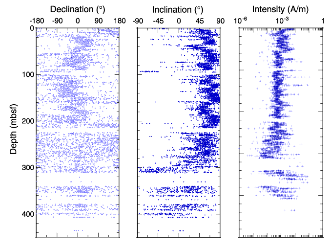
The first panel shows the declination (which isn't very useful), and the second shows the inclination (which is used to recognize normal and reversed polarities). Positive inclinations are normal, negative inclinations are reversed. You can see that polarity of Earth's magnetic field changed several times while these sediments were being deposited. Measuring the remnant magnetization of sediments and looking at the record of polarity changes they record is called magnetostratigraphy.
Post #110
We can draw that line, those lines, but there are several things that the map doesn't show us. If the ridge were the only force acting on these plates, then we would be able to extrapolate where the plates were at what time in geologic history. However, other plates are also involved, pushing and nudging like timbers in a logjam. Add to this the -- so far -- relatively unknown effects of convection. The plates are floating on top of liquid rock, and we would expect that the behavior of this molten sea would have some kind of effect. We just don't have a clear idea of how that sea is moving or what might be driving it.otseng wrote:ST88 wrote: Looking at the ocean floor map wouldn't tell you much about past movements. It might tell you in general where the pressure is coming from and where the boundaries are, but it wouldn't reliably show how a plate would (or did) move.
I would disagree. If plate tectonics says that the ridge is the boundary point of a plate, then it can show how the plate moved. In the map of the mid-Atlantic ridge, we can practically draw a line from a point on the coast to where it should have started on the ridge. I do not see how it could've moved otherwise.
It is possible that South America, for example, moved in a direction exactly perpendicular to the Mid-Atlantic ridge (or the average of that line or whatever). It is also possible that it moved up, down, rotated a bit, and even moved exactly reverse of its current direction, and still have the pattern it does now. What are we to make, for example, of the space between the ridge in the central Atlantic and the Carribean side of South America; and the space between the ridge in the southern Atlantic and the Argentine side of South America? If SA moved due west, these spaces should be the same, but they are not. We might be able to say that SA rotated clockwise a bit at a point near northern Brazil, for example. But we could also say that the ridge in the south is more active than the ridge in the north and has therefore pushed more material out of the way. And we could also say that South America is made up of more than one plate and just happens to be in this configuration at this point in geologic time. My point here is not to promote any one of these ideas, it's to show that the map doesn't show what the movements are.otseng wrote:I think you're making the assumption that plate tectonics dictates that all of the continents must move exactly according to where the Mid-Atlantic ridge is now.
You are probably right about me making that assumption. If America/Europe/Africa did not move due west/east from the ridge, then how did it move? How could it have left a "trail" that goes due west/east if it did not move due west/east?
There are different faults working in different directions. For example, in East Africa, the movement is diverging west from the Arabian plate, even though the entire continent appears to be drifing east. There are also other plates acting on each other. There are also convection currents underneath the surface.otseng wrote:
Be assured that this is not the only force working on these continents. Not only are they working on each other also, but they are subject to numerous other forces. Also, please note that the speed of movements are not necessarily stable over time.
What are these forces? How did the force seem to change in the past as compared to now?
Yes, I was wondering when you were going to get to this. It represents yet another set of unknowns that could be filled by YEC. However, even the movements of the Americas were completed over millions of years judging by the radiometric dating map. Plus there's the problem of the subduction of oceanic plates underneath continental plates. If this process was completed within a year (as an example), it would not have the, shall we say, finesse of creating pointy mountain ranges like the Andes and the Sierra Nevadas.otseng wrote:If it is not stable over time, then how do we not know it might have went much faster in the past (like within perhaps one year)? Also, as I explained above, the ridge is currently expanding at a magnitude and direction that is different than how the continents are currently moving.
John S answered this pretty well, but I'll just add this:otseng wrote:Some questions about magnetic anomalies. What exactly causes these magnetic anomalies? Are we talking about the magnetic field of the earth changing in intensity or somehow changing in polarity in the past?
- Paleomagnetism (Natural Remnant Magnetism) - Iron-bearing rocks contain minerals like magnetite which act as fossil compasses. The Earth's magnetic field orientation is "frozen in" these iron-bearing minerals when igneous rocks are cooled below the Curie Point (about 580 degrees C for magnetite). Later movement of the rock can be determined by the orientation of the current magnetic field compared to the rock's paleomagnetism. The declination (angle away from true north) of the paleomagnetism gives the longitude that the rock formed at, and the inclination (tilt from horizontal) gives the latitude.
- Polar Wandering - Study of paleomagnetism of rocks showed that either (1) the magnetic poles have moved dramatically in the Earth's past, or (2) that the continents have changed position relative to stationary magnetic poles, or (3) that both continents and magnetic poles have moved. The only way to reconcile the apparent paleomagnetic inconsistency and produce only one N and S pole (rather than different poles for each continent) is explanation (2). When the continents are fitted together, the paleomagnetic data points to one magnetic pole each in the Northern and Southern Hemispheres.
Plate Tectonics
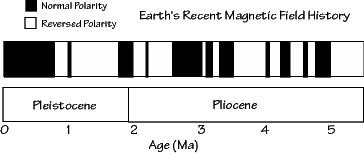
This timeline might help conceptualize the changes in the earth's magnetic field.
