
Several years ago (more then one, less then ten thousand) the idea that the Earth was not the center of the Universe was high in the ranks of things we argued about. Neatly behind that would be the age of the Universe, age of the Earth, the Earth goes around the sun, Earth is flat, etc. In time, a number of these ideas were accepted by pretty much everyone. By that I mean that I doubt even YEC will argue the point that the Earth is the center of the Universe and in addition to being flat also has the sun and everything else revolve around it.
On that line of thinking, I'd like to ask what you think of plate tectonics in that regard. It isn't brought up much on these boards, but because it neatly explains how we get fossils and strata on opposite sides of the Ocean all neatly lined up (such as the shore between Africa and South America), I imagine there must be some controversy surrounding it.
So, plate tectonics, is it like the Earth being round, or closer to evolution in terms of the amount of public debate surrounding it?
Plate Techtonics!
Moderator: Moderators
Plate Techtonics!
Post #1"Secular schools can never be tolerated because such schools have no religious instruction, and a general moral instruction without a religious foundation is built on air...we need believing people."
[Adolf Hitler, April 26, 1933]
[Adolf Hitler, April 26, 1933]
-
otseng

- Savant
- Posts: 20977
- Joined: Thu Jan 15, 2004 1:16 pm
- Location: Atlanta, GA
- Has thanked: 218 times
- Been thanked: 390 times
- Contact:
Post #91
Still the question remains. How can a single plate have places where they move at different directions, and even more strange, different rates? One clear example is South America. Even if one were to account for the Earth being a sphere, they still go in different directions. Also, South America should be moving west because the ridges are growing in the mid-Atlantic. But, the GPS measurements show that it is moving northeast. So, this shows that ridge growth is not related to continental movement.Nyril wrote:The Earth is roundish, like a ball. The picture is flat, like a piece of paper, indeed, exactly like a piece of paper. 10 lines that may be perfectly in alignment on a sphere, are not guaranteed to be in the same direction if you flatten that sphere out, which is why I included the caption I highlighted for that picture.Locations on a single plate are moving in different directions and different rates. If it is a "plate" that is moving, then why do different places move at different directions and different rates all on the same plate?
The mid-Indian Ocean ridge is growing at 2.7 cm/yr. Yet, there are points in Africa that point directly to that vicinity. This is further evidence that ridge growth has no bearing on continental movement.Into Europe from the looks of things. Remember, subduction zones are not required where plates meet.Africa is moving northeast, but there is no subduction zone in that direction. Where is it going?
I would now conclude that ridge growth has nothing to do with continental movement. Especially given the fact that points on the continents are moving at different rates than ridge growth.Putting your numbers aside for a moment, you need to consider that the ocean ridges is not the exclusive force behind plate tectonics, you've got convection currents pushing the plates as well, so plate movement is not limited by ridge growth.
I thought genies were not allowed.Jose wrote:I will invoke the genie of ocean currents.otseng wrote:Also, sediments are found for hundreds of miles off the coasts. How could runoff-sediments from the coast go for hundreds of miles underwater?
I did not take fluid dynamics, so this will require further explanation. It does not seem feasible to me so I'll need to be convinced.
Actually, I have argued that what I would expect to see when two plates collide is compression (deformation). My understanding of subduction zones is that one plate simply "slips" under another. No mention of compression or deformation accompanies the descriptions of subductions that I've seen.John S wrote: It seems to me that you're changing your expectations about sediment thicknesses in subduction zones. From your post of March 31:
otseng wrote:If there are places where large amounts of rocks are rubbing against each other, it would be in the subduction zones. What we should expect to see are evidence of rubbing at these areas through sediments. If these subduction zones existed for millions of years, we should see massive amounts of sediments at these locations. So, do we see this?
http://www.platetectonics.com/book/page_12.aspWhen two oceanic plates collide, the younger of the two plates, because it is less dense,* will ride over the edge of the older plate.
http://geology.about.com/library/bl/bln ... uction.htmOnce a plate begins to subduct, gravity takes over. A descending plate is usually referred to as a "slab". In the western Pacific where very old seafloor is being subducted, the slab falls almost straight down.
So, it is in this sense that I use the word "rub". Other terms could be "slide" or "ride". But, since two rock layers are in direct contact with each other, rubbing seems like the more appropriate term to use.

One question I have about this diagram is how did they determine these ages?
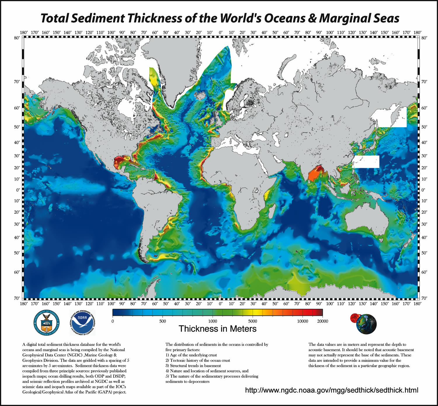
Certainly. But we see also see thick sediments along the entire coast of North America. How did that get there?Why are there thick sediments in the Gulf of Mexico? The Mississippi River delta. Why are there thick sediments near Nigeria and Equitorial Guinea in Africa? The Congo River delta. Why are there thick sediments near the part of India you asked about? That's the Ganges River delta. Why are there thick sediments off the coast of Brazil? The Amazon River delta.

Post #92
I haven't participated in this debate much, but I'd just like to throw out an answer I found to otseng's question of how the age of sea crusts were determined...

Source: Oceanography[/url]
You can read more about the magnetic anomalies from the source...The age of the oceanic crust does not go back farther than about 200 million years. Such crust is being formed today at oceanic spreading centres. Many ophiolites are much older than the oldest oceanic crust, demonstrating continuity of the formation processes over hundreds of millions of years. Methods that may be used to determine the age of the crustal material include direct dating of rock samples by radiometric dating (measuring the relative abundances of a particular radioactive isotope and its daughter isotopes in the samples) or by the analyses of fossil evidence, marine magnetic anomalies, or ocean depth. Of these, magnetic anomalies deserve special attention.
Source: Oceanography[/url]
Post #93
I really enjoy your posts Jose. I should probably start this post with the warning that I'm not a geodicist. However, I am fairly familiar with the San Andreas fault system. Your're certainly right that the boundary between the Pacific plate and the North American plate is more complex than shown in the simplified diagram from the USGS. The boundary isn't just the San Andreas fault - it's a wider system of faults. The only interpretation of the figure that I'm willing to make is that the rocks east of the broad San Andreas system are moving SE relative to the rocks west of that system. Undoubtedly a GPS expert could tell you more, but unfortunately that's not me.Jose wrote:Nonetheless, the question still remains, if in a more complex form. My naive expectation would be that to the east of the San Andreas, vectors would generally trend southeast, with similar magnitude. To the west, vectors would generally trend northwest, with similar magnitude, as implied by the USGS simplified diagram:
Naturally, we don't see that, since there are gazillions of faults crisscrossing California, with lots of potential movements. Nonetheless, we do see that stations on either side of the San Andreas can be moving the same direction at the same rate--say, where it crossses the Garlock Fault, illustrated by the two tandem vectors trending southeast from EDPP.
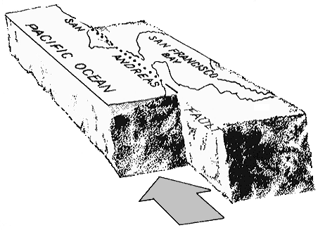
I can't help you much with the geography (I'm a pretty new Californian), but I'm happy to give you a gold star. Earthquake prediction still isn't feasible (well, maybe with margins of error of 100's to 1000's of years, or maybe 10's in a good case), but you are correct that geodetic movements can be used to get information about fault slip rates, which is a component in determining the probability of failure along a fault. It's certainly not the whole story. Earthquake prediction is definitely a goal that members of the geologic community are working towards, but nobody's there yet, except with very coarse (on a human time scale) estimates that I mentioned earlier.Jose wrote: Having said this, I'll also note that the cluster of vectors in the upper left of the diagram (where would that be? Los Olivos?) are clearly just as you said--the east portion is clearly sliding southeast relative to the west portion. Do I get a gold star if I say, "I bet this is part of the evidence they use to tell us that some portions of the fault are under more strain than others, and could generate The Big One any time when they finally slip"? Or is that too simplistic, since there are so many other faults in the LA area, which make it look like the whole region is crumbling apart as if it was trying to join the channel islands?
Post #94
It's not a matter of compression vs. subduction/slipping - Compressive stresses (i.e. squeezing things together) drive subduction. In other words, one plate subducting underneath another is an indication of compression. Think about a subduction zone as a giant thrust fault (the image on the right in this figure):otseng wrote: Actually, I have argued that what I would expect to see when two plates collide is compression (deformation). My understanding of subduction zones is that one plate simply "slips" under another. No mention of compression or deformation accompanies the descriptions of subductions that I've seen.

Thrust faults are caused by compression (imagine taking a block like the one in the figure - squeeze it together and you'll get motion like that shown in the figure).
bigmrpig's post addressed this, and I can't add much. I will make a few comments. There're three main ways:direct radiometric dating of the crust, the pattern of magnetic anomalies (more on this later), and the age of the sediments deposited over the crust (the crust will be older than the youngest sediments deposited on top of it). I've mentioned the Integrated Ocean Drilling Program and it's predecessors before. The ocean crust has been sampled in a lot of places, providing a lot of direct dates. As I think has been mentioned before, the pattern of magnetic anomalies (normal vs. reversed polarities) is generally symmetric about a ridge - this means that if you date the crust on one side of a ridge, you know the age of the symmetric "mirror image" crust on the other side of the ridge. You can do more with the pattern of magnetic anomalies. It's starting to veer off-topic, but I think it's worth mentioning. The pattern of normal and reversed polarities can also be a kind of fingerprint. For example let's say you know what the pattern of magnetic anomalies looks like in an area that's been accurately dated (through radiometric dating, etc.). When you see an area with the same type of pattern you can infer that it's the same age. This isn't a universally applicable technique though - patterns may be nonunique, and the pattern of normal vs. reverse polarities has only been determined back through the Jurassic (as shown in this figure):otseng wrote: One question I have about this diagram is how did they determine these ages?

From a post I made yesterday:otseng wrote: Certainly. But we see also see thick sediments along the entire coast of North America. How did that get there?
John S wrote: You asked why are there thick accumulations of sediments off of eastern North America, eastern south America, and western Africa? It's because the crust there is old. Older crust has had more time to accumulate sediments than younger crust.
Post #95
John S covered this.Still the question remains. How can a single plate have places where they move at different directions, and even more strange, different rates?
John S wrote:Relative to station CAT1 LA is moving southeast. Relative to someone standing in Nevada LA is moving northwest. Knowing which reference frame was used is very important for interpreting GPS data.
Your image shows the subduction coast is on the west side of Africa. Every line I can see in NASA's picture seems to be posting east. Have I overlooked some?The mid-Indian Ocean ridge is growing at 2.7 cm/yr. Yet, there are points in Africa that point directly to that vicinity. This is further evidence that ridge growth has no bearing on continental movement.
Potassium-Argon dating.osteng wrote:One question I have about this diagram is how did they determine these ages?
"Secular schools can never be tolerated because such schools have no religious instruction, and a general moral instruction without a religious foundation is built on air...we need believing people."
[Adolf Hitler, April 26, 1933]
[Adolf Hitler, April 26, 1933]
-
otseng
- Savant
- Posts: 20977
- Joined: Thu Jan 15, 2004 1:16 pm
- Location: Atlanta, GA
- Has thanked: 218 times
- Been thanked: 390 times
- Contact:
Post #96
To me, it appears that the age was determined primarily through the sediment analysis. There is no way to do a comprehensive (or even close) radiometric dating of the entire ocean floor. Yet, the diagram shows practically all of the ocean floor. The magnetic anomalies are only at the ridges, so that is also a small part of the ocean floor. Primarily using sediment analysis to predict the crust age is suspect to me. One problem with this is the assumption that the rates of deposition have occured at the same rate in the past as now. It is furthur suspect if it is then used to show that there are more sediments there because the age of the crust is old.John S wrote:There're three main ways:direct radiometric dating of the crust, the pattern of magnetic anomalies (more on this later), and the age of the sediments deposited over the crust (the crust will be older than the youngest sediments deposited on top of it).
On the diagram, practically all of the coasts are old. Yet, there are significantly more deposits on the eastern coast of North America than any other coast. Why the difference?John S wrote: You asked why are there thick accumulations of sediments off of eastern North America, eastern south America, and western Africa? It's because the crust there is old. Older crust has had more time to accumulate sediments than younger crust.
I do not see how John S answers the questions with this statement. His explanation does not address any of the inconsistencies that I pointed out.Nyril wrote:John S covered this.Still the question remains. How can a single plate have places where they move at different directions, and even more strange, different rates?
John S wrote:Relative to station CAT1 LA is moving southeast. Relative to someone standing in Nevada LA is moving northwest. Knowing which reference frame was used is very important for interpreting GPS data.
This is the image from where I got the information from:Your image shows the subduction coast is on the west side of Africa. Every line I can see in NASA's picture seems to be posting east. Have I overlooked some?The mid-Indian Ocean ridge is growing at 2.7 cm/yr. Yet, there are points in Africa that point directly to that vicinity. This is further evidence that ridge growth has no bearing on continental movement.
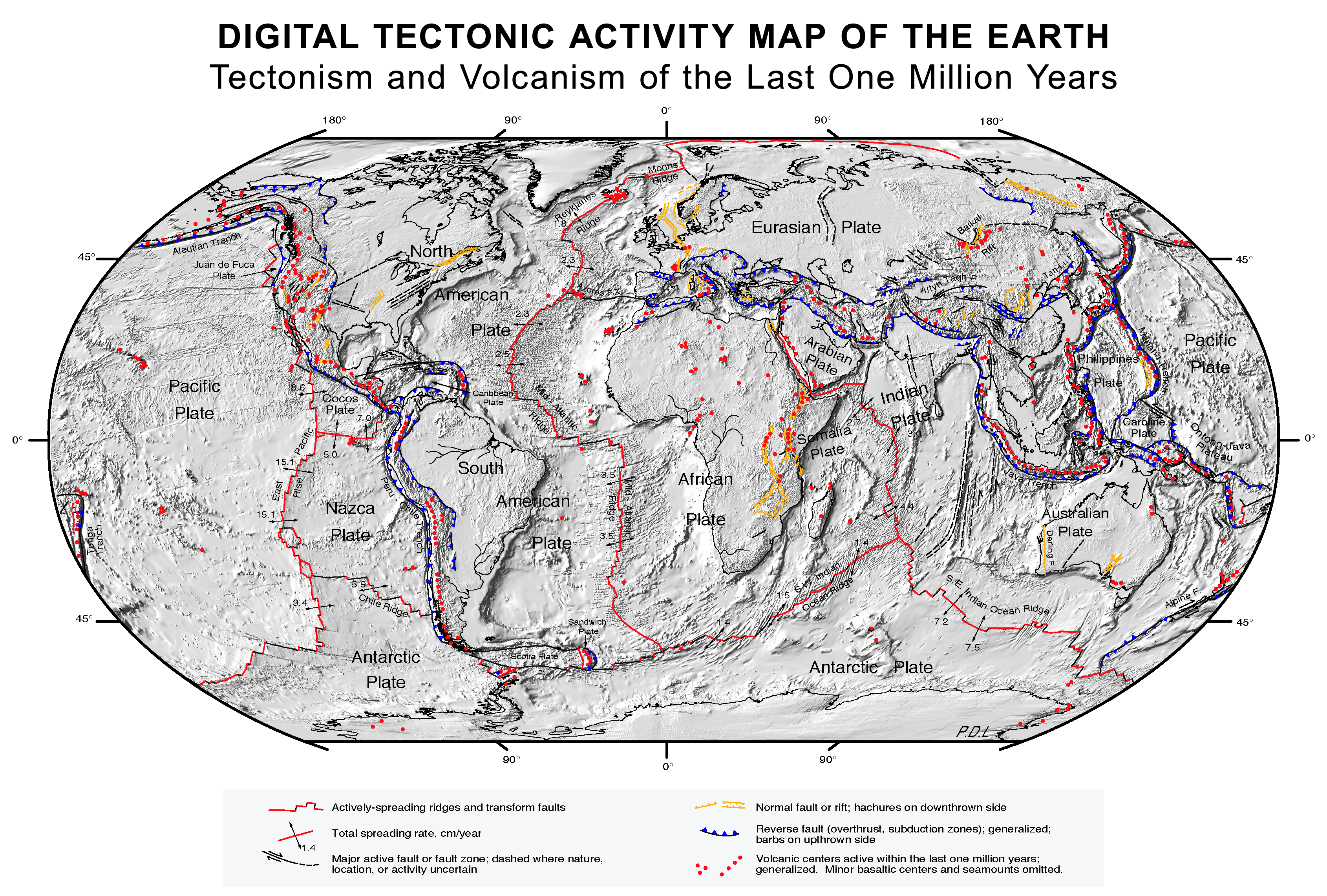
http://upload.wikimedia.org/wikipedia/c ... cs_map.gif
Post #97
I'm not sure if this question was addressed to me or otseng, but I'll answer it. There's no subduction off the west coast of Africa, so I'm not sure what you're referring to there. With regard to the relative motion of the African and Indian plates, otseng said:nyril wrote: Your image shows the subduction coast is on the west side of Africa. Every line I can see in NASA's picture seems to be posting east. Have I overlooked some?
I think otseng is referring to this image for directions of plate motions. The velocity vectors for both the African and Indian plates are pointing to the northeast, as otseng referred to. But you should note the length of the velocity vectors - a longer vector equals a faster velocity. The vectors are longer on the Indian plate than on the African plate, so the Indian plate is travelling faster. This means that relative to the African plate the Indian plate is moving to the northeast. In other words there's spreading going on at the ridge otseng mentioned.otseng wrote:The mid-Indian Ocean ridge is growing at 2.7 cm/yr. Yet, there are points in Africa that point directly to that vicinity. This is further evidence that ridge growth has no bearing on continental movement.
Post #98
Interesting ideas, but you're making some unfounded assumptions. The age of the ocean floor is not assumed primarily from the amount of sediment - that's not a factor in calculating the age of the ocean crust at all. The age of the crust would be inferred from the age, not the thickness, of the overlying sediments. But that's not how oceanic crust is primarily dated - that's done through the combination of magnetic anomalies and radiometric dating that I mentioned before. Magnetic anomalies don't just exist at ridges - the entire ocean floor is composed of areas that have normal polarities and areas that have reversed polarities. These areas are generally symmetric about the ridge, but they're not limited to it, maybe that's the source of confusion.otseng wrote: To me, it appears that the age was determined primarily through the sediment analysis. There is no way to do a comprehensive (or even close) radiometric dating of the entire ocean floor. Yet, the diagram shows practically all of the ocean floor. The magnetic anomalies are only at the ridges, so that is also a small part of the ocean floor. Primarily using sediment analysis to predict the crust age is suspect to me. One problem with this is the assumption that the rates of deposition have occured at the same rate in the past as now. It is furthur suspect if it is then used to show that there are more sediments there because the age of the crust is old.
Magnetic stripes and isotopic clocks from the USGS
Take a look at the more colorful, more detailed image that I linked to earlier. It's easier to see the age of the crust on that image - I didn't directly link to the image in my earlier post since it's so large. The crust off the eastern coast of North America is some of the oldest oceanic crust - so I'd bet that's still the dominant reason the sediments are so thick there.otseng wrote: On the diagram, practically all of the coasts are old. Yet, there are significantly more deposits on the eastern coast of North America than any other coast. Why the difference?
You asked:otseng wrote:I do not see how John S answers the questions with this statement. His explanation does not address any of the inconsistencies that I pointed out.John S wrote:Relative to station CAT1 LA is moving southeast. Relative to someone standing in Nevada LA is moving northwest. Knowing which reference frame was used is very important for interpreting GPS data.
I responded:otseng wrote: Locations on a single plate are moving in different directions and different rates. If it is a "plate" that is moving, then why do different places move at different directions and different rates all on the same plate?
Why doesn't that answer your question? Is that not one of the plates you were referring to? Am I missing something? If I am, let me know.John S wrote: Do you mean plates like North America in the image you linked to? That means North America is rotating. Think about what velocity vectors of a record or a merry-go-round would look like - in the middle you're not going anywhere, you're just spinning - toward the edge you're moving a lot more. Just using the naked eye in the image you linked to it looks to me like North America is rotating about a point somewhere near the Yucutan Peninsula.
You also asked:
My point about reference frames did directly answer those questions, but I guess I wasn't clear enough. I elaborated on Africa in my post to Nyril that's two posts before this one.otseng wrote: Why are there several location moving away from the subduction zone, like the west coast of South America and Europe/Central Asia?
Africa is moving northeast, but there is no subduction zone in that direction. Where is it going?
South America and the Nazca plate (the plate with EISL on it) are converging - relative to South America the Nazca plate is moving toward it. That's certainly compatible with the subduction of the Nazco plate under South America. There's no requirement that the convergence can't be oblique, or in other words that the direction of plate motion is at an angle to the subduction zone. The net result is that South America and the Nazca plate are moving closer together.
I'm not sure what you're referring to with regards to Asia and Europe. To me it looks like Europe and Asia are rotating around a point somewhere near Indonesia.

Post #99
There are many factors that cause the earth to move (small "e") in individual places. Plate movements are macro-movements of the crust, but as someone who has lived in California all my life, I can tell you that there are faults everywhere.otseng wrote:Still the question remains. How can a single plate have places where they move at different directions, and even more strange, different rates? One clear example is South America. Even if one were to account for the Earth being a sphere, they still go in different directions. Also, South America should be moving west because the ridges are growing in the mid-Atlantic. But, the GPS measurements show that it is moving northeast. So, this shows that ridge growth is not related to continental movement.
Someone please correct me if I'm wrong, here. Assume for the moment that these fissures are part of the forces that move plates. Look at the pressures on South America. To the east there is the Mid-Atlantic ridge pressing it west, and the Nazca plate is pushing it east. Where would you go if there were forces pressing on both sides? Answer: up. In the case of South America, it is currently heading in a northward direction, seemingly getting squished by both forces.
I understand there is a theory that the Indian Ocean was once one single plate, but that it has cracked, and that these cracks are not as deep as other major plate boundaries. Does anyone have any information on this?
Additionally...
Other participants in this wonderful thread might be interested in an animated representation of the breakup of Pangea over the last 150 million years, showing the movements of the continents over time since then. Little more than fun, really, but they provide visuals for all of this.
The first one is slower to load, and the map is a little harder to read.
http://www.classzone.com/books/earth_sc ... ualization
http://www.scotese.com/pangeanim.htm
Note the movements of India and the body of water off the coast of the Eastern U.S. My personal favorite movement is the Carribean Islands.
-
otseng
- Savant
- Posts: 20977
- Joined: Thu Jan 15, 2004 1:16 pm
- Location: Atlanta, GA
- Has thanked: 218 times
- Been thanked: 390 times
- Contact:
Post #100
Just to clarify, I did not say that the age was based solely on the sediment thickness, but simply sediment analysis. Furthermore, radiometric dating has its own set of assumptions which are debateable. But, I will leave that for another thread.John S wrote:The age of the ocean floor is not assumed primarily from the amount of sediment - that's not a factor in calculating the age of the ocean crust at all.
There is not enough information here for me to make any constructive comments. Data missing includes where the measurements were taken and measurement data.Magnetic stripes and isotopic clocks from the USGS
I took a further look and noticed even more discrepencies. All throughout the western part of the Pacific Ocean is supposedly old crust. Yet, there are not the huge sediment deposits that we should expect to see if it really is that old. Also, the area between Africa and Madagascar is old, but there is not a huge amount of sediments.Take a look at the more colorful, more detailed image that I linked to earlier.
(I am basing my sediment data from here)
Yet, the question remains, how did the sediments get there? Jose explained it through ocean currents, but lacked any details on the mechanism. Perhaps you could elaborate on this more for us.It's easier to see the age of the crust on that image - I didn't directly link to the image in my earlier post since it's so large. The crust off the eastern coast of North America is some of the oldest oceanic crust - so I'd bet that's still the dominant reason the sediments are so thick there.
Looking at the map of the ocean floor, it appears that the Americas moved due west. Not much (if any) rotations are evident from the ocean floor map.Why doesn't that answer your question? Is that not one of the plates you were referring to? Am I missing something? If I am, let me know.John S wrote: Do you mean plates like North America in the image you linked to? That means North America is rotating. Think about what velocity vectors of a record or a merry-go-round would look like - in the middle you're not going anywhere, you're just spinning - toward the edge you're moving a lot more. Just using the naked eye in the image you linked to it looks to me like North America is rotating about a point somewhere near the Yucutan Peninsula.

(Click on image for larger map)
Now, it does not correlate with the GPS data of the continents.

As you stated, the "North America is rotating about a point somewhere near the Yucutan Peninsula". This movement would indicate that it did not move due west from the mid-Atlantic ridge.
South America is generally moving north from GPS data. So, this is in contrast to it having moved due west.
Europe and Africa are moving northeast. Yet the coast of Europe/Africa matches the mid-Atlantic ridge only if it moved due east.
Also, I have pointed out that the velocities of the continental movement does not match the rate of growth of the ridges in several places.
All these factors together (plus others) shows to me that there is no correlation between ridge growth and continental movement.
