
Several years ago (more then one, less then ten thousand) the idea that the Earth was not the center of the Universe was high in the ranks of things we argued about. Neatly behind that would be the age of the Universe, age of the Earth, the Earth goes around the sun, Earth is flat, etc. In time, a number of these ideas were accepted by pretty much everyone. By that I mean that I doubt even YEC will argue the point that the Earth is the center of the Universe and in addition to being flat also has the sun and everything else revolve around it.
On that line of thinking, I'd like to ask what you think of plate tectonics in that regard. It isn't brought up much on these boards, but because it neatly explains how we get fossils and strata on opposite sides of the Ocean all neatly lined up (such as the shore between Africa and South America), I imagine there must be some controversy surrounding it.
So, plate tectonics, is it like the Earth being round, or closer to evolution in terms of the amount of public debate surrounding it?
Plate Techtonics!
Moderator: Moderators
Plate Techtonics!
Post #1"Secular schools can never be tolerated because such schools have no religious instruction, and a general moral instruction without a religious foundation is built on air...we need believing people."
[Adolf Hitler, April 26, 1933]
[Adolf Hitler, April 26, 1933]

Post #61
Before attempting to say something intelligent in response to your questions, I'll offer a link to the measured ages of ocean floor rock. Click on their image for a full map of the world. That is: we have measured the rates of movement, we have determined the ages of the rocks; it all adds up to plate tectonics. Now, I may have mis-spoken earlier about the force of movement. I suggested that the magma spilling from the cracks pushes the plates, but it makes more sense that the convection in the mantle moves the crust above it. As the plates are moved apart, there is no choice but to develop cracks between them, through which magma flows.
I imagine that when Europe and North America first started to move apart, the crust broke, and formed the faults. Continued movement would stress the "sealed" cracks, which, being weak due to the cracks, would re-crack and spill more magma. (As opposed to developing miscellaneous cracks all over the ocean floor, from the formation of entirely new cracks).
Why the stair-steps in the main crack of the Ridge itself? I can imagine that in some places, over the millenia, magma spread a little faster on the east than the west in one part of the Ridge, and a little faster on the west in a different part of the Ridge. Segments of the Ridge/main crack could become offset by such a process. Having said this, I note that it is based entirely on instantaneous logic, and has no data to back it up. It seems feasible, is all.
I imagine that when Europe and North America first started to move apart, the crust broke, and formed the faults. Continued movement would stress the "sealed" cracks, which, being weak due to the cracks, would re-crack and spill more magma. (As opposed to developing miscellaneous cracks all over the ocean floor, from the formation of entirely new cracks).
Well, the fracture line between the plates is, essentially, a line. The crack isn't just a single hole. From a hole, cracks would radiate outward (like the dikes of the Spanish Peaks near Walsenburg, CO). But from a linear crack, continued strain would seem likely to produce lots of cracks. If the ocean floor is moving away from the central crack, it would make sense that the "accessory cracks" might be aligned with the direction of movement.otseng wrote:If magma was coming out of the ridges continuously, then what I would expect is that the magma would come out radially. Like if I boil a pot of water and it overflows, it would come out all around the pot. But if we look at the ridge, the ridge material is only perpendicular to the ridge. There is an easily observable "stair-step" pattern in the ridge. How can magma coming out of the ground produce such distinct lines?
Also, why do we see fracture lines running perpendicular to the ridges? How could they have formed?
Why the stair-steps in the main crack of the Ridge itself? I can imagine that in some places, over the millenia, magma spread a little faster on the east than the west in one part of the Ridge, and a little faster on the west in a different part of the Ridge. Segments of the Ridge/main crack could become offset by such a process. Having said this, I note that it is based entirely on instantaneous logic, and has no data to back it up. It seems feasible, is all.
I don't quite know how it works (understatement), but suppose that the magma forms a gooey mass as it comes up, and before it solidifies entirely, some gets pulled out sideways, and some pushes upward a bit. That which moves out sideways produces ocean floor, and that which pushes upward makes a ridge. I'd imagine bits of junk make lumps on the ocean floor, too, but they move away with the spreading sea floor, and don't accumulate to such heights as at the main crack where the Ridge forms.otseng wrote:Why are the surfaces of the ridges so "bumpy"? If magma came out of the ground, I would expect it to produce a much smoother terrain.
Panza llena, corazon contento
-
otseng

- Savant
- Posts: 20845
- Joined: Thu Jan 15, 2004 1:16 pm
- Location: Atlanta, GA
- Has thanked: 214 times
- Been thanked: 363 times
- Contact:
Post #62
Let's take Jose's image of the plates and subduction zones:

If there are places where large amounts of rocks are rubbing against each other, it would be in the subduction zones. What we should expect to see are evidence of rubbing at these areas through sediments. If these subduction zones existed for millions of years, we should see massive amounts of sediments at these locations. So, do we see this?
Again, the relative difference of density between two rocks is not going to force one to go up and the other to go down if they collide. Also, these plates are not just a few meters thick, they are several kilometers thick. When two plates hit, how can one plate displace itself by several kilometers to go under another plate?
Another observation from the diagram above, there are several plates where there are no (or very little) subduction zones - African plate, Antarctic plate, and Eurasian plate. If there are no subduction in these plates, then we should see evidence of compression/folding within these plates. Perhaps more so than any other plates. Do we see evidence of this?
If there are places where large amounts of rocks are rubbing against each other, it would be in the subduction zones. What we should expect to see are evidence of rubbing at these areas through sediments. If these subduction zones existed for millions of years, we should see massive amounts of sediments at these locations. So, do we see this?
So, how can it be explained that, in the above diagram, the Himalayas is in a subduction zone?MagusYanam wrote: It all has to do with the thickness of the plates in contact. The density of the material comprising the oceanic plates and the continental plates is similar, but because continental plates displace more of the asthenosphere than the thinner oceanic plates do, the continental plates tend overall to be less dense than the oceanic. Where the densities of the lithospheric material are similar enough, yes, compression does occur. That's what Himalaya is. So what's the force causing one plate to move underneath another? Gravity. A more useful answer might be that it is convection of the asthenosphere driving plate movements and gravity that causes the denser materials to sink in it.
Again, the relative difference of density between two rocks is not going to force one to go up and the other to go down if they collide. Also, these plates are not just a few meters thick, they are several kilometers thick. When two plates hit, how can one plate displace itself by several kilometers to go under another plate?
Another observation from the diagram above, there are several plates where there are no (or very little) subduction zones - African plate, Antarctic plate, and Eurasian plate. If there are no subduction in these plates, then we should see evidence of compression/folding within these plates. Perhaps more so than any other plates. Do we see evidence of this?
Post #63
Imagine two people meeting in a hallway in which they can't pass one another. Each needs to continue down, but turning back isn't an option. To solve the problem, they elect to have one person go over the other. Although the first person is indeed being subducted, as the second person stands on the first, an observer that couldn't see the feet would believe the man to be a foot taller then he actually was. In the instances of rocks, the rocks can't lay down, so the person in our example would be standing on his shoulders.So, how can it be explained that, in the above diagram, the Himalayas is in a subduction zone?
"Secular schools can never be tolerated because such schools have no religious instruction, and a general moral instruction without a religious foundation is built on air...we need believing people."
[Adolf Hitler, April 26, 1933]
[Adolf Hitler, April 26, 1933]

Post #64
You're probably not going to like this answer, but the vast majority of the sediment created at subduction zones is taken down into with the subducted plate. Mostly this is because in a subduction zone the oceanic plate is the one going under, so, after settling on the ocean floor, the sediments are carried downward with the ocean plate.otseng wrote:If there are places where large amounts of rocks are rubbing against each other, it would be in the subduction zones. What we should expect to see are evidence of rubbing at these areas through sediments. If these subduction zones existed for millions of years, we should see massive amounts of sediments at these locations. So, do we see this?
But there is something called an accretionary wedge that forms when the sediments from the subducted oceanic plate are scraped off in the process of subduction. These sediments become metamorphosed and solidified such that they can be appended to the edge of the continental plate. Such wedges occur along the eastern Pacific: Chile, Costa Rica, and Oregon.
I'd often wondered that also. How can subduction occur between two continental plates where compression should be the result? The Himalayas have a lot of weird stuff going on. The Indian plate, for all intents and purposes, is being subducted into the Eurasian plate, but it turns out that it's not that simple. This is called continent-continent convergence, and neither continent is giving much of any ground.otseng wrote:So, how can it be explained that, in the above diagram, the Himalayas is in a subduction zone?
This is my rough summary, someone please correct me if I've taken too many liberties with the story.
Part of the problem here is that there used to be an ocean that covered roughly the area around where the subduction zone appears on the map, called the Tethys ocean, which itself appeared around the time of the breakup of Pangea -- another topic. The former ocean known as Tethys subducted itself entirely underneath the Eurasian plate, followed by the Indian plate, whose front end filled up the space left by the Tethys ocean, underneath the Eurasian plate. But because the Indian plate is a continental plate and is more bouyant (less dense) than the Tethys oceanic material, it refused to go all the way under. The result is that not only are the Himalayas being created (as we speak) by buckling (compression), but the Tibetan Plateau was also raised behind it.
Here are some illustrations of the process:

http://pubs.usgs.gov/publications/text/ ... nding.html
If you'll notice the direction of the African plate, it is not in conflict with any of the other plates, so there is little in the way of collision activity. In fact, there is very little activity at all with the African plate:otseng wrote:Another observation from the diagram above, there are several plates where there are no (or very little) subduction zones - African plate, Antarctic plate, and Eurasian plate. If there are no subduction in these plates, then we should see evidence of compression/folding within these plates. Perhaps more so than any other plates. Do we see evidence of this?
There are some interesting things happening on the horn of Africa, but that's a different conversation.[Geologist Kevin Burke] begins with the widely recognized observation that "Africa hasn't moved much with respect to the mantle beneath it" for 200 million years. In fact, "it hasn't moved at all in the past 30 million years." Africa just doesn't have much get up and go, because it lacks the cold, dense slabs of sinking ocean plate found off Japan and South America. There, as the slabs sink into the mantle, they exert a powerful pull on the plates to which they are attached. In contrast, the African plate- -the continent and its surrounding ocean crust--is bounded on nearly all sides by midocean ridges that push against it only gently as new crust spreads away from the ridges.
From Earth's Core to African Oil - Science Magazine
The same thing is true with the Antarctic plate, that it is relatively quiet, although it seems that less is known about this plate than perhaps any other in the world.
Post #65
Perhaps it would help a little to look at a couple of figures--two representations of the same dataset. These show the locations of earthquake epicenters:


Seismic activity is most common where there are subduction zones, and next-most common at the spreading centers. In the subduction zones, the sediment doesn't build up because it melts and fuels the volcanoes that give us names like "the Ring of Fire."
I will second the explanations put forward by ST88 and Nyril. They match my understanding of the process. I'll also note that ST88's comment on the shrinkage of the Tethys Sea helps me understand why the Indian Plate would attempt to dive under the Eurasian Plate. If the ocean floor was being subducted as the Indian Plate moved north, then as the continental mass approached Eurasia, it would tend to follow the crustal material ahead of it--and tilt downward into the subduction zone. I hadn't thought of this before, but it does provide a good explanation for how the two plates "decided" which would bend down, and which would crawl over. At this point, they've kinda gotten stuck--so we see less seismic activity there than we do around the Ring of Fire, particularly on the west side of the Pacific.
The upper map, in particular, helps me see the relationship of Africa to the other plates. It looks like Africa is sort of sitting still, with spreading centers on both sides. To Africa's west, the Americas are moving over the pacific Plate; to Africa's east, the Indian and Australian Plates (or Indo-Australian Plate, if we prefer) are moving into Eurasia and over the Pacific Plate. Judging from the numbers of the dots, I'd even suggest that the Indo-Australian unit has slowed down in its creation of the Himalayas, and is now rotating counter-clockwise, almost pivoting around the Himalayas, and creating earthquake-havoc from Sumatra to the Phillipines to New Guinea.
Panza llena, corazon contento
-
MagusYanam

- Guru
- Posts: 1562
- Joined: Mon Jan 17, 2005 12:57 pm
- Location: Providence, RI (East Side)
Post #66
Simply put, Jose's diagram would seem to be erroneous in that regard, or not specific enough to really tell the story of what's going on in the Himalaya geologically. It is true that subduction of the oceanic crust has occurred, but there are problems with the model that subduction alone is what caused Himalaya to happen. I submit this article:otseng wrote:So, how can it be explained that, in the above diagram, the Himalayas is in a subduction zone?
en.wikipedia.org/wiki/Geology_of_the_Himalaya
Especially this portion:
It is clear that it is not simple subduction which caused Himalaya, based just on what evidence is available.Wikipedia wrote:Whilst most of the oceanic crust was "simply" subducted below the Tibetan block during the northward motion of India, at least three major mechanisms have been put forward, either separately or jointly, to explain what happened, since collision, to the 2400 km of "missing continental crust". The first mechanism also calls upon the subduction of the Indian continental crust below Tibet. Second is the extrusion or escape tectonics mechanism (Molnar and Tapponier, 1975) which sees the Indian plate as an indenter that squeezed the Indochina block out of its way. The third proposed mechanism is that a large part (~1000 km, Dewey et al. 1989) of these 2400 km of crustal shortening since collision was accommodated by thrusting and folding of the sediments of the passive Indian margin together with the deformation of the Tibetan crust.
Even though it is more than reasonable to argue that this huge amount of crustal shortening most probably results from a combination of these three mechanisms, it is nevertheless the last mechanism which created the high topographic relief of the Himalaya.
-
otseng
- Savant
- Posts: 20845
- Joined: Thu Jan 15, 2004 1:16 pm
- Location: Atlanta, GA
- Has thanked: 214 times
- Been thanked: 363 times
- Contact:
Post #67
The only thing presented has been the rate of how much the ridges have grown, but it doesn't demonstrate that the plates are moving. Perhaps what would be helpful are measurements of the continents themselves growing farther apart.Jose wrote: That is: we have measured the rates of movement, we have determined the ages of the rocks; it all adds up to plate tectonics.
How exactly does convection in the mantle cause plates to move?Now, I may have mis-spoken earlier about the force of movement. I suggested that the magma spilling from the cracks pushes the plates, but it makes more sense that the convection in the mantle moves the crust above it. As the plates are moved apart, there is no choice but to develop cracks between them, through which magma flows.
However, the lines are a series of lines, not just a single line. Each line stops and starts with the next "stair-case". At the ends of the lines, magma should come out radially (at least in a semi-circular fashion). Again, distinct lines are evident in all the ridges. I cannot see how magma coming out of the ground can form these.Well, the fracture line between the plates is, essentially, a line. The crack isn't just a single hole.
But why a stair-step pattern? It should not be so delineated, but rather should exhibit curves, rather than lines.Why the stair-steps in the main crack of the Ridge itself? I can imagine that in some places, over the millenia, magma spread a little faster on the east than the west in one part of the Ridge, and a little faster on the west in a different part of the Ridge.
Let's take a more appropriate scenario. Suppose two slabs of rock 100 feet high meet each other in a 200 foot high hallway. Each slab is as wide as the hallway so there is no way to go around the other. Each slab is 1000 feet long (it's a long hallway). Two bulldozers are pushing on each end of the slab of rock. What would we expect to see when the two slabs of rock meet? Compression and folding. What if one slab has a density of 2 g/cc and the other had 6 g/cc? Would it be any different? I doubt it.Nyril wrote:Imagine two people meeting in a hallway in which they can't pass one another. Each needs to continue down, but turning back isn't an option. To solve the problem, they elect to have one person go over the other. Although the first person is indeed being subducted, as the second person stands on the first, an observer that couldn't see the feet would believe the man to be a foot taller then he actually was. In the instances of rocks, the rocks can't lay down, so the person in our example would be standing on his shoulders.
So, in other words, there is no evidence of any rubbing/sediments at any of the subduction zones. This also is quite hard to believe. Two pieces of rock rubbing against each other probably generates more rock sediments than any other process. Also, we are talking about a lot of time and rock length to have been grated against each other. Even with a conservative estimate of a 500 mile length of the western plate of the US that was subducted, surely there must be some sediments to show for it.ST88 wrote: You're probably not going to like this answer, but the vast majority of the sediment created at subduction zones is taken down into with the subducted plate. Mostly this is because in a subduction zone the oceanic plate is the one going under, so, after settling on the ocean floor, the sediments are carried downward with the ocean plate.
If subduction occurs at the Himalayas, then it runs counter to a statement you made earlier:The Indian plate, for all intents and purposes, is being subducted into the Eurasian plate, but it turns out that it's not that simple.
ST88 wrote: A primary factor is the relative bouyancy of the continents and plates on top of the aesthenosphere. This is a vast oversimplification, but because the ocean plates are made up of heavier elements -- megnesium, iron -- and the landmasses are made up of lighter elements -- silicon, aluminum -- the continental plates are more bouyant than the ocean plates. This principle is called isostacy. This is why continental plate boundaries are not subducted. You will only find subduction in ocean plate boundaries, and this is due to gravity.
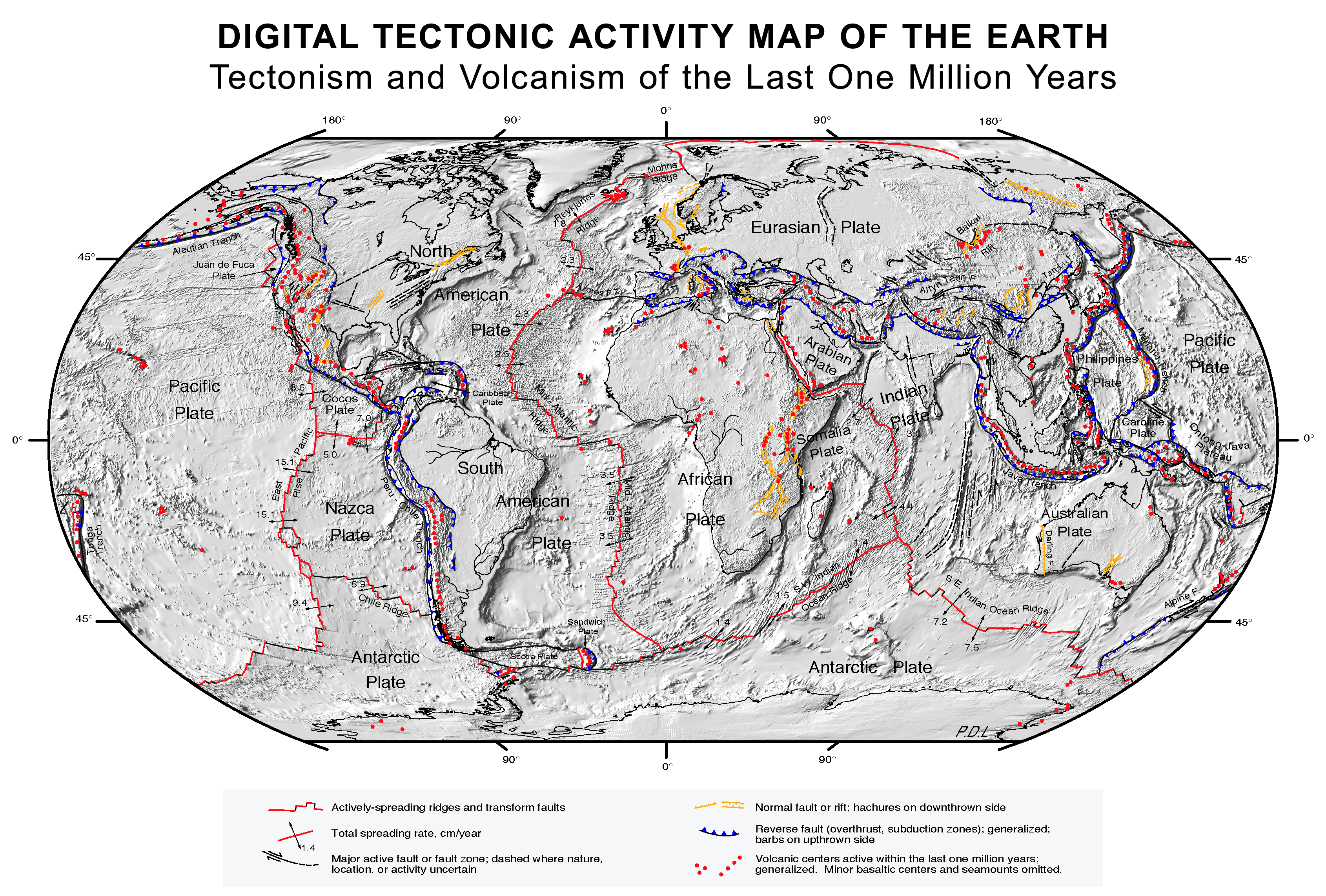
Jose's image does not quite give the full story. Here is a larger picture that gives a more comprehensive view of the plates: Plate tectonics map.If you'll notice the direction of the African plate, it is not in conflict with any of the other plates, so there is little in the way of collision activity. In fact, there is very little activity at all with the African plate:
Notice that all of the ridges are moving. Even the ones surrounding the African plate, the Antarctic plate, and the Eurasian plate. So, again, why do we not see evidence of extreme compression/folding within these plates if there are little to none subduction zones at these plates?
Post #68
Certainly. Here's a vector field map of the area. The website is linked in the picture.Perhaps what would be helpful are measurements of the continents themselves growing farther apart.

Here's a bigger one from Nasa. Again, click the picture for the link.This map shows current movements of the Eurasian, African, Indian and Arabian lithospheric plates relative to the Global Positioning System (GPS) satellite network. The differences among individual stations are due to deformation of the plates at their edges and distortion produced by the Mercator projection of the map. The information on this map was last updated in August 2002.


As you can see, the movements of the plates are very well recorded.
What you need to understand is that the plates are floating. Just as you can float in water (or even better, on a vat of mercury) the plates are floating on the liquid mantel. The liquid is far more dense then the surface, and the movement of the fluid below it moves the plates just as convection currents in a boiling pot of pasta move macaroni around rather quickly.How exactly does convection in the mantle cause plates to move?
Why curves? What's wrong with lines?But why a stair-step pattern? It should not be so delineated, but rather should exhibit curves, rather than lines.
Float the rocks, and yes, there will be a difference. Once one even begins to go under the other, the pressure will continue this until one is subducted under the other.What would we expect to see when the two slabs of rock meet? Compression and folding. What if one slab has a density of 2 g/cc and the other had 6 g/cc? Would it be any different? I doubt it.
ST88 answered your question, and this response is simply repeating your previous question that ST88 answered.So, in other words, there is no evidence of any rubbing/sediments at any of the subduction zones. This also is quite hard to believe. Two pieces of rock rubbing against each other probably generates more rock sediments than any other process.
I'm not sure what you're saying, a vast majority of the coastlines presented in your graphic appears to be zones in which subduction occurs, with the only notable exception being Africa which is already known to be one of the most stable plates on the planet.So, again, why do we not see evidence of extreme compression/folding within these plates if there are little to none subduction zones at these plates?
"Secular schools can never be tolerated because such schools have no religious instruction, and a general moral instruction without a religious foundation is built on air...we need believing people."
[Adolf Hitler, April 26, 1933]
[Adolf Hitler, April 26, 1933]
-
MagusYanam
- Guru
- Posts: 1562
- Joined: Mon Jan 17, 2005 12:57 pm
- Location: Providence, RI (East Side)
Post #69
Elementary, my dear otseng (if you will pardon the Conan Doyle cliche). Convection in the atmosphere causes clouds to move. Cool air sinks, displacing warmer air, causing a convection pattern. The same applies to the asthenosphere. Cooler molten rock (nearer the surface) sinks, displacing the molten rock which had been warming nearer the core. That warmer molten rock rises, then becomes relatively cool as it nears the surface. The resulting convection currents carry the lithospheric plates with them, like a conveyor belt.otseng wrote:How exactly does convection in the mantle cause plates to move?
I tend to think of this sort of action like the ripples on a pond created when you skip a stone across it. The waves, where one crest meets another (or one trough another) amplify each other. Where a crest meets a trough, they cancel out. Each skip forms a ring of waves, but the overall effect shows waves moving out in straight lines (a more drastic example would be a boat's wake, where the waves are being formed continuously and the straight-line wave effect is far stronger).otseng wrote:But why a stair-step pattern? It should not be so delineated, but rather should exhibit curves, rather than lines.
This analogy, while more appropriate, still looks a shade specious to me. It doesn't look as though it takes into account the fact that these slabs are in fact floating on a denser fluid, or their relative dimensions. Suppose now that two overhead projector sheets meet floating in a basin of water eleven inches wide and seventeen inches long, so there is no way for one to move around the other and no way back. One overhead projector sheet is twice as thick as the other and has a lower average density, and thus floats higher (on average) in the water than does the thin one. When they meet, what do you expect will happen? The thinner one will flex more than the thicker one, and thus will be folded and forced beneath the water.otseng wrote:Let's take a more appropriate scenario. Suppose two slabs of rock 100 feet high meet each other in a 200 foot high hallway. Each slab is as wide as the hallway so there is no way to go around the other. Each slab is 1000 feet long (it's a long hallway). Two bulldozers are pushing on each end of the slab of rock. What would we expect to see when the two slabs of rock meet? Compression and folding. What if one slab has a density of 2 g/cc and the other had 6 g/cc? Would it be any different? I doubt it.
A bold statement; does it have any evidential basis? Remember that, while the results are cumulative over very long periods of time (so we can make generalisations about tectonic behaviour), seismic activity occurs in singular events. Earthquakes and volcanic eruptions (with some exceptions) are not continuous phenomena, so the rocks aren't really 'rubbing' against each other continuously. Rather, stress builds up in the regions surrounding a fault until something gives and the plates shift. Result? Earthquake. Sediment is inevitably produced, but in a singular event of remarkably short duration. Cumulatively, wind and water win the sediment production contest.otseng wrote:Two pieces of rock rubbing against each other probably generates more rock sediments than any other process.
Post #70
I didn't say there wasn't any evidence. I did say that there are accretion wedges at the continental edge of subduction zones, made up of compressed sediment from the oceanic plate as it gets scraped off by the continental plate. Otherwise there would be no reason for the accretion wedges -- attached to the continental plates -- to have oceanic materialotseng wrote:So, in other words, there is no evidence of any rubbing/sediments at any of the subduction zones. This also is quite hard to believe. Two pieces of rock rubbing against each other probably generates more rock sediments than any other process. Also, we are talking about a lot of time and rock length to have been grated against each other. Even with a conservative estimate of a 500 mile length of the western plate of the US that was subducted, surely there must be some sediments to show for it.ST88 wrote: You're probably not going to like this answer, but the vast majority of the sediment created at subduction zones is taken down into with the subducted plate. Mostly this is because in a subduction zone the oceanic plate is the one going under, so, after settling on the ocean floor, the sediments are carried downward with the ocean plate.
Welllll... I guess you got me on a technicality. Technically speaking, the Indian plate has been subducted, but because these are two continental plates, it's very limited and has already stopped in geologic time. The Indian plate was following the Tethys Ocean as far as it could go underneath the Eurasian plate, but because the relative bouyancies of the two continental plates were about the same, the subduction did not completely happen. I was thinking mostly about ocean to continental plate boundaries when I made the above statement -- the ocean plate is always subducted because of gravity. Please keep in mind that the Himalayas represent the only plate collision of this type currently existing in the world.otseng wrote:If subduction occurs at the Himalayas, then it runs counter to a statement you made earlier:The Indian plate, for all intents and purposes, is being subducted into the Eurasian plate, but it turns out that it's not that simple.ST88 wrote: A primary factor is the relative bouyancy of the continents and plates on top of the aesthenosphere. This is a vast oversimplification, but because the ocean plates are made up of heavier elements -- megnesium, iron -- and the landmasses are made up of lighter elements -- silicon, aluminum -- the continental plates are more bouyant than the ocean plates. This principle is called isostacy. This is why continental plate boundaries are not subducted. You will only find subduction in ocean plate boundaries, and this is due to gravity.
Even in the new graphic, the direction of the plates surrounding the African plate indicate that they are all moving in concert, so there is very little conflict between the plates, therefore little reason for there to be extreme compression. Just because there's no subduction going on doesn't automatically mean that there must be compression somewhere.otseng wrote:Jose's image does not quite give the full story. Here is a larger picture that gives a more comprehensive view of the plates: Plate tectonics map.If you'll notice the direction of the African plate, it is not in conflict with any of the other plates, so there is little in the way of collision activity. In fact, there is very little activity at all with the African plate:
Notice that all of the ridges are moving. Even the ones surrounding the African plate, the Antarctic plate, and the Eurasian plate. So, again, why do we not see evidence of extreme compression/folding within these plates if there are little to none subduction zones at these plates?
There is some weird stuff going on between the African and the Arabian plate, whose relative divergence has created the Dead Sea, the Red Sea, and Lake Tanganyika.
