
Several years ago (more then one, less then ten thousand) the idea that the Earth was not the center of the Universe was high in the ranks of things we argued about. Neatly behind that would be the age of the Universe, age of the Earth, the Earth goes around the sun, Earth is flat, etc. In time, a number of these ideas were accepted by pretty much everyone. By that I mean that I doubt even YEC will argue the point that the Earth is the center of the Universe and in addition to being flat also has the sun and everything else revolve around it.
On that line of thinking, I'd like to ask what you think of plate tectonics in that regard. It isn't brought up much on these boards, but because it neatly explains how we get fossils and strata on opposite sides of the Ocean all neatly lined up (such as the shore between Africa and South America), I imagine there must be some controversy surrounding it.
So, plate tectonics, is it like the Earth being round, or closer to evolution in terms of the amount of public debate surrounding it?
Plate Techtonics!
Moderator: Moderators
Plate Techtonics!
Post #1"Secular schools can never be tolerated because such schools have no religious instruction, and a general moral instruction without a religious foundation is built on air...we need believing people."
[Adolf Hitler, April 26, 1933]
[Adolf Hitler, April 26, 1933]
-
otseng

- Savant
- Posts: 20845
- Joined: Thu Jan 15, 2004 1:16 pm
- Location: Atlanta, GA
- Has thanked: 214 times
- Been thanked: 363 times
- Contact:
Post #81
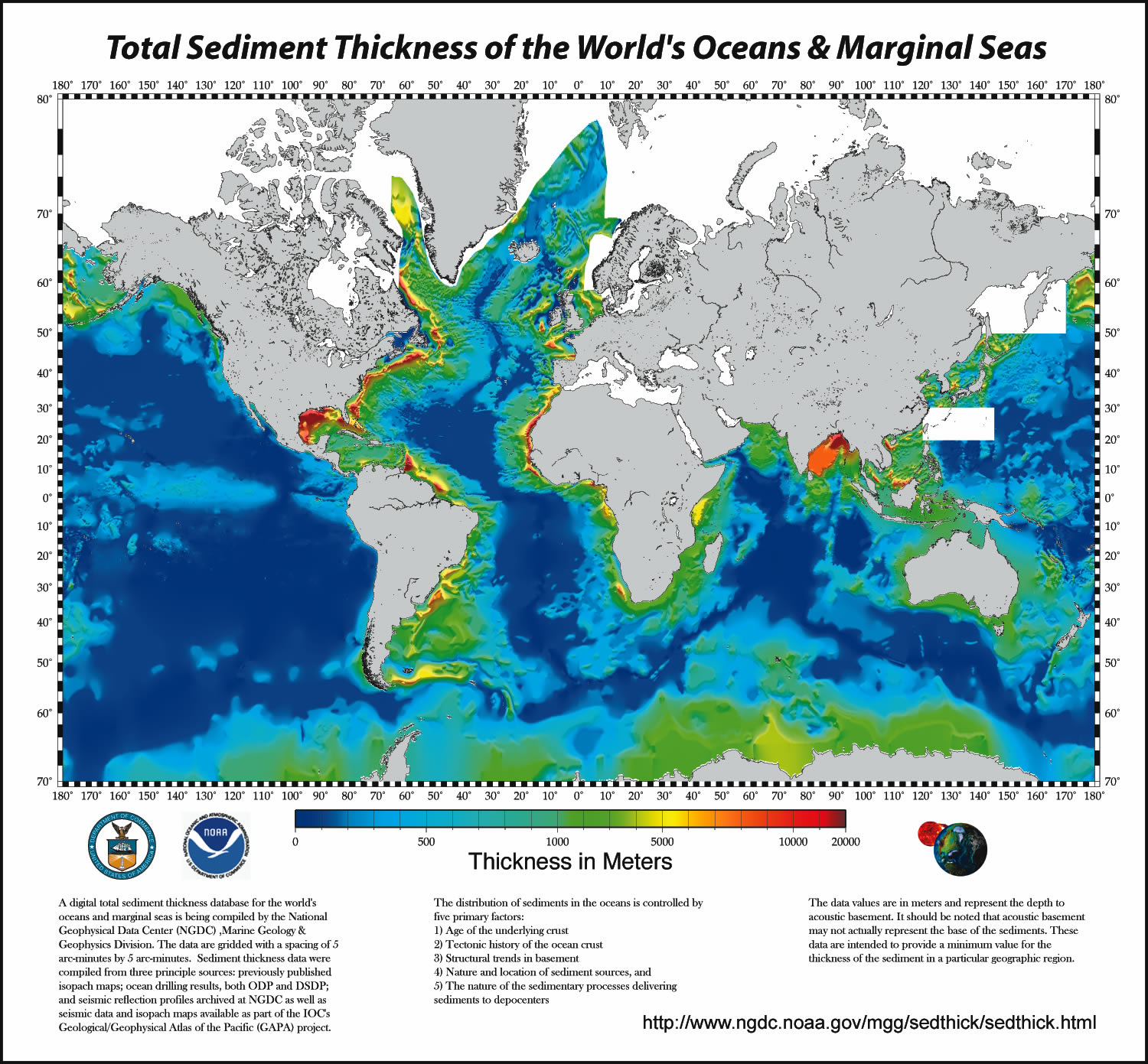
Let's look at some more comprehensive pictures.Jose wrote:Thanks, John! The seismic images are exactly what I wanted. Now, I may be naive, but it seems like a couple of km of sediment qualifies as "lots." I think this meets otseng's expectation.
In the diagram below, the subduction zones are indicated in red.

What we should expect to see is that the thickest sediments should be near the red lines above.
Now, let's correlate this with the map of the total sediment thickness of the world's oceans.
Instead, we see that the thickest areas of sediments in the ocean are off the east coast of North America, some off the east coast of South America, the west coast of Africa, east coast of India, and some other areas. We notice that the subduction zones are in none of these areas. Futhermore, there is no evidence of much sediments in any of the subduction zones.

Post #82
I'm not entirely sure what constitutes the "acoustic basement" for these sediments (defined as the "bottom" in the link you provided). It may be the original seafloor extruded through the spreading centers...but I'll have to defer to John S for this. I can, however, say that the places with the most sediment are the places that plate tectonics predicts would have the most sediment. That is, if "sediment" is defined as relatively soft mud that increases in compaction until we reach the hard stuff (acoustic basement), then it will primarily be the result of erosional runoff from continents. It will accumulate where the sea floor is stable--where there are no subduction zones. Where subduction zones exist, these runoff-sediments will be subducted along with the hard rock of the ocean crust.otseng wrote:What we should expect to see is that the thickest sediments should be near the red lines above.
Now, let's correlate this with the map of the total sediment thickness of the world's oceans.
Instead, we see that the thickest areas of sediments in the ocean are off the east coast of North America, some off the east coast of South America, the west coast of Africa, east coast of India, and some other areas. We notice that the subduction zones are in none of these areas. Futhermore, there is no evidence of much sediments in any of the subduction zones.
Just for laughs, I'll point out that the sediment map isn't all that favorable for the flood model, either--which predicts that sediment should be the deepest in the places that are lowest, and that lack ocean ridges. That is, the Pacific sea floor should be full of sediment, according to that model.
So, here we have some data that seem to contradict your expectation for tectonic activity and the expecation for the flood. Welcome to science.
Panza llena, corazon contento
-
otseng
- Savant
- Posts: 20845
- Joined: Thu Jan 15, 2004 1:16 pm
- Location: Atlanta, GA
- Has thanked: 214 times
- Been thanked: 363 times
- Contact:
Post #83
Jose wrote:It will accumulate where the sea floor is stable--where there are no subduction zones. Where subduction zones exist, these runoff-sediments will be subducted along with the hard rock of the ocean crust.
However, there are relatively little sediments around Australia and there are no subduction zones around that continent. Same for Antarctica. Why should there be more sediments on the west coast of Africa than on the east coast?
Also, sediments are found for hundreds of miles off the coasts. How could runoff-sediments from the coast go for hundreds of miles underwater?
Just for laughs, I'll point out that the sediment map isn't all that favorable for the flood model, either--which predicts that sediment should be the deepest in the places that are lowest, and that lack ocean ridges. That is, the Pacific sea floor should be full of sediment, according to that model.
Again, I wish to avoid discussions about the FM here in this thread, but the data seems consistent to me. The hydroplates as they settled down onto the underlaying basalt layer got "dragged" along and thus leaving sediments along the way. So, that is why we see relatively little sediments off the west coast of the Americas and a lot off the east coast. And it also explains why we see sediments for hundreds of miles off the coasts.
-
otseng
- Savant
- Posts: 20845
- Joined: Thu Jan 15, 2004 1:16 pm
- Location: Atlanta, GA
- Has thanked: 214 times
- Been thanked: 363 times
- Contact:
Post #84
Interesting diagram. Certainly this is evidence that the continents are moving. However, there are several things in the diagram that seem to contradict plate tectonics.Nyril wrote: Here's a bigger one from Nasa. Again, click the picture for the link.

Locations on a single plate are moving in different directions and different rates. If it is a "plate" that is moving, then why do different places move at different directions and different rates all on the same plate?
Why are there several location moving away from the subduction zone, like the west coast of South America and Europe/Central Asia?
Africa is moving northeast, but there is no subduction zone in that direction. Where is it going?
The magnitude of the lines are not consistent with the growth of the ridges. The ridge in the mid-Atlantic is growing at a rate of 2.3 cm/year. But, the longitudinal rate of the points on North American is smaller. Taking one point, DUBO, the longitudinal rate of movement is 1.84 cm/year. The ridge below Australia is growing at 7.5 cm/yr. But the total movement rate of HOB2 is 5.7 cm/yr. How can the continents be moving at a different rate than the rate of growth of the ridges?

Similar questions also apply to this image. Why are they moving parallel to a subduction zone? How can they move at different rates?
Post #85
The Earth is roundish, like a ball. The picture is flat, like a piece of paper, indeed, exactly like a piece of paper. 10 lines that may be perfectly in alignment on a sphere, are not guaranteed to be in the same direction if you flatten that sphere out, which is why I included the caption I highlighted for that picture.Locations on a single plate are moving in different directions and different rates. If it is a "plate" that is moving, then why do different places move at different directions and different rates all on the same plate?
The differences among individual stations are due to deformation of the plates at their edges and distortion produced by the Mercator projection of the map.
I don't know. However I don't see why it needs to move towards the subduction zone, the ocean plate is the one moving and expanding, it likely pushes the plates away as it does such.Why are there several location moving away from the subduction zone, like the west coast of South America and Europe/Central Asia?
Into Europe from the looks of things. Remember, subduction zones are not required where plates meet.Africa is moving northeast, but there is no subduction zone in that direction. Where is it going?
Putting your numbers aside for a moment, you need to consider that the ocean ridges is not the exclusive force behind plate tectonics, you've got convection currents pushing the plates as well, so plate movement is not limited by ridge growth.The magnitude of the lines are not consistent with the growth of the ridges. The ridge in the mid-Atlantic is growing at a rate of 2.3 cm/year. But, the longitudinal rate of the points on North American is smaller.
"Secular schools can never be tolerated because such schools have no religious instruction, and a general moral instruction without a religious foundation is built on air...we need believing people."
[Adolf Hitler, April 26, 1933]
[Adolf Hitler, April 26, 1933]
Post #86
Look at the point EISL, in the ocean to S. America's west. It's moving toward S. America faster than S. America can get out of its way. They're both moving the same direction, but the plate behind is moving faster. It's kinda like getting rear-ended on the highway by someone going faster than you are.otseng wrote:Why are there several location moving away from the subduction zone, like the west coast of South America and Europe/Central Asia?
It looks to me, from the vectors, that Africa is moving at the same rate, and in the same direction, as Europe. Here, instead of a rear-end collision, everyone's going the same speed, so no one gets a ticket.otseng wrote:Africa is moving northeast, but there is no subduction zone in that direction. Where is it going?
I was more puzzled by the fact that the channel islands are moving northwest, but the LA basin is moving southeast. The San Andreas is to the east of LA, running through Palm Springs and thence northwest. This makes it look, to me, as if Baja California and the bits of California to the west of the fault are slipping above the contrary plate motion below them. I would have expected to see the NW/SE movement demarcation at the San Andreas, not to its west. Live and learn.otseng wrote:Similar questions also apply to this image. Why are they moving parallel to a subduction zone? How can they move at different rates?
Even so, "relatively little" still seems to be a km or two. That would make a respectable height for a mountain around here, and thus seems reasonably substantial to me.otseng wrote:However, there are relatively little sediments around Australia and there are no subduction zones around that continent. Same for Antarctica. Why should there be more sediments on the west coast of Africa than on the east coast?
I will invoke the genie of ocean currents. There's a lot of stirring going on in the ocean--as the FM postulates must have occurred (but on a grander scale) during the flood. I am particularly impressed by the tail of sediment that strings out to the east from Tierra del Fuego. That has the look of sediment dropped by a current after passing a barrier, and becoming turbulent (or the formation of snowdrifts or cornices when wind-blown snow passes a barrier). We'd need to check known ocean currents to determine whether my hypothesis is borne out (it predicts a current going eastward past S. America).otseng wrote:Also, sediments are found for hundreds of miles off the coasts. How could runoff-sediments from the coast go for hundreds of miles underwater?
Yes, indeed. It's so tempting...but I'll behave myself. Let's take up that conversation later. This one's too much fun to interrupt.otseng wrote:Again, I wish to avoid discussions about the FM here in this thread, but...
Panza llena, corazon contento
Post #87
It seems to me that you're changing your expectations about sediment thicknesses in subduction zones. From your post of March 31:otseng wrote:Instead, we see that the thickest areas of sediments in the ocean are off the east coast of North America, some off the east coast of South America, the west coast of Africa, east coast of India, and some other areas. We notice that the subduction zones are in none of these areas. Futhermore, there is no evidence of much sediments in any of the subduction zones.
It appears to me that you were asking "Are there sediments with evidence of deformation ("rubbing") in subduction zones", but now you're asking "Why aren't the thickest sediments found at subduction zones"? Those are two different questions. I believe that my post on the Nankai trough answers your original question; as for the second, the reason that the thickest sediments aren't found in subduction zones is that there's more than subduciton that controls sediment thickness.otseng wrote:If there are places where large amounts of rocks are rubbing against each other, it would be in the subduction zones. What we should expect to see are evidence of rubbing at these areas through sediments. If these subduction zones existed for millions of years, we should see massive amounts of sediments at these locations. So, do we see this?
From the figure you linked to:
"The distribution of sediments in the ocean is controlled by five primary factors:
1) Age of the underlying crust
2) Tectonic history of the ocean crust
3) Structural trends in basement
4) Nature and location of sediment sources, and
5) The nature of the sedimentary processes delivering sediments to depocenters"
With that in mind let's revisit the figure showing sediment thickness.
You asked why are there thick accumulations of sediments off of eastern North America, eastern south America, and western Africa? It's because the crust there is old. Older crust has had more time to accumulate sediments than younger crust.

or see this link for a larger, more colorful map.
Why are there thick sediments in the Gulf of Mexico? The Mississippi River delta. Why are there thick sediments near Nigeria and Equitorial Guinea in Africa? The Congo River delta. Why are there thick sediments near the part of India you asked about? That's the Ganges River delta. Why are there thick sediments off the coast of Brazil? The Amazon River delta.
Post #88
I can't add much to Jose's post, but I can clarify the meaning of acoustic basement.Jose wrote: I'm not entirely sure what constitutes the "acoustic basement" for these sediments (defined as the "bottom" in the link you provided). It may be the original seafloor extruded through the spreading centers...but I'll have to defer to John S for this.
The sediment thicknesses on the map otseng linked to were measured from the kind of seismic images that I linked to in my post about the Nankai trough. This type of imaging is sensitive to changes in velocity (a change in velocity results in a reflector - the lines you see on the images from Nankai). A very pronounced change in velocity results in a very pronounced reflector. When you move from soft sediments to underlying rock (like basalt in the case of the ocean floor), that results in a prominent reflector that's called acoustic basement.
You can see examples of that here:
http://www.appliedacoustics.com/mainframe/subbottom_profiling/squid2000bds_data.htm
and here:
http://www-odp.tamu.edu/publications/185_SR/001/001_f4.htm
As a side note, acoustic basement doesn't necessarily coincide with a change from sedimentary to nonsedimentary rock - for example if you're looking at Quaternary sediments deposited on top of Paleozoic rocks acoustic basement will be the contact between the two.
Post #89
There's a couple points to consider here.otseng wrote: Locations on a single plate are moving in different directions and different rates. If it is a "plate" that is moving, then why do different places move at different directions and different rates all on the same plate?
Why are there several location moving away from the subduction zone, like the west coast of South America and Europe/Central Asia?
Africa is moving northeast, but there is no subduction zone in that direction. Where is it going?
1) "Locations on a single plate are moving in different directions and different rates."
Do you mean plates like North America in the image you linked to? That means North America is rotating. Think about what velocity vectors of a record or a merry-go-round would look like - in the middle you're not going anywhere, you're just spinning - toward the edge you're moving a lot more. Just using the naked eye in the image you linked to it looks to me like North America is rotating about a point somewhere near the Yucutan Peninsula. BUT you need to consider the second point:
2) All of the velocities shown in both of the figures you linked to are shown relative to a particular reference point. The velocity vectors are relative velocity vectors. Imagine the you're in the right lane of the freeway going 60 MPH and you're friend next to you is in the left lane going 60 MPH. Relative to you you're friend is travelling 0 MPH. Relative to somesone standing on the side of the road he's moving at 60 MPH. In the first, global, image I'm not sure what reference point is used (I'd guess that it's some sort of astronomical reference point, but I don't know). That's not really important for this example - can you see how the velocity vectors would be different if they were drawn relative to the point labelled KERG on the map than if they were drawn relative to the point labelled PAMA (just picking two points at random)?
The velocity vectors in the second image from California are shown relative to CAT1, which looks to me like it's a station in the Catalina Islands. This answers Jose's problem:
Relative to station CAT1 LA is moving southeast. Relative to someone standing in Nevada LA is moving northwest. Knowing which reference frame was used is very important for interpreting GPS data.Jose wrote:I was more puzzled by the fact that the channel islands are moving northwest, but the LA basin is moving southeast. The San Andreas is to the east of LA, running through Palm Springs and thence northwest. This makes it look, to me, as if Baja California and the bits of California to the west of the fault are slipping above the contrary plate motion below them. I would have expected to see the NW/SE movement demarcation at the San Andreas, not to its west. Live and learn.
Post #90
Yes, I admit I was looking primarily at the directions of a mere subset of the vectors, not the magnitudes when I wrote that. Certainly, the cluster of short vectors in LA, relative to the much longer vectors to the east (GOLD and BKAP), your explanation is clear.John S wrote:Relative to station CAT1 LA is moving southeast. Relative to someone standing in Nevada LA is moving northwest. Knowing which reference frame was used is very important for interpreting GPS data.
Nonetheless, the question still remains, if in a more complex form. My naive expectation would be that to the east of the San Andreas, vectors would generally trend southeast, with similar magnitude. To the west, vectors would generally trend northwest, with similar magnitude, as implied by the USGS simplified diagram:
Naturally, we don't see that, since there are gazillions of faults crisscrossing California, with lots of potential movements. Nonetheless, we do see that stations on either side of the San Andreas can be moving the same direction at the same rate--say, where it crossses the Garlock Fault, illustrated by the two tandem vectors trending southeast from EDPP.
Having said this, I'll also note that the cluster of vectors in the upper left of the diagram (where would that be? Los Olivos?) are clearly just as you said--the east portion is clearly sliding southeast relative to the west portion. Do I get a gold star if I say, "I bet this is part of the evidence they use to tell us that some portions of the fault are under more strain than others, and could generate The Big One any time when they finally slip"? Or is that too simplistic, since there are so many other faults in the LA area, which make it look like the whole region is crumbling apart as if it was trying to join the channel islands?
Panza llena, corazon contento
