
Several years ago (more then one, less then ten thousand) the idea that the Earth was not the center of the Universe was high in the ranks of things we argued about. Neatly behind that would be the age of the Universe, age of the Earth, the Earth goes around the sun, Earth is flat, etc. In time, a number of these ideas were accepted by pretty much everyone. By that I mean that I doubt even YEC will argue the point that the Earth is the center of the Universe and in addition to being flat also has the sun and everything else revolve around it.
On that line of thinking, I'd like to ask what you think of plate tectonics in that regard. It isn't brought up much on these boards, but because it neatly explains how we get fossils and strata on opposite sides of the Ocean all neatly lined up (such as the shore between Africa and South America), I imagine there must be some controversy surrounding it.
So, plate tectonics, is it like the Earth being round, or closer to evolution in terms of the amount of public debate surrounding it?
Plate Techtonics!
Moderator: Moderators
Plate Techtonics!
Post #1"Secular schools can never be tolerated because such schools have no religious instruction, and a general moral instruction without a religious foundation is built on air...we need believing people."
[Adolf Hitler, April 26, 1933]
[Adolf Hitler, April 26, 1933]

Post #121
That's not really a discrepancy. In the strictest sense of the word, the oatmeal bubbling model is not random, but is predicated on the structure of the material that, by definition, we can't see (if we pry apart the oatmeal to see what's going on, we'll have changed it).otseng wrote:And yet we have a discrepency. Plate tectonics says that mantle convection is not random. The mantle convection would have to have been fixed for periods measured in the millions of years.I suspect that the global oatmeal pot is also random, but on a very much slower timescale.
Mantle convection also depends on the structure of the material. One major difference is that the oatmeal convection happens in a closed concave vessel. Mantle convection happens in a continuous convex vessel (so convex as to be spherical-ish).
otseng, you might be interested in this:otseng wrote:I would agree with that and do not dispute it. But, what I do dispute is that it necessarily leads to the conclusion that the magnetic field of the earth has reversed in polarity every thousands/millions of years. What other evidence besides magnetic anomalies would point to the fact that the earth has experienced many magnetic polarity reversals?The magnetic anomalies are Facts.
There is some evidence that certain radiolarian & other species extinctions are linked to the observed reversal dates.Evidences for changes in the strength of the terrestrial magnetic field also stem from the variation in isotopes as 14C and 10Be which are created by the galactic cosmic radiation and stored in terrestrial archives such as the ice sheets. Since their production increases with decreasing magnetic field strength, their intensities are a measure for the geomagnetic field.
At the time of polarity reversal, fossil records often indicate the extinction of different plant species. In addition, magnetic field reversals are often associated with climate changes. Today it is not clear whether this points to causal relationships and if it does which mechanisms might be involved.
Within this project, we attempt to test the hypotheses that a chain of physical processes is responsible for the changes in system Earth during a geomagnetic polarity reversal:
1. the reduced geomagnetic field leads to an increased precipitation of solar energetic particles and galactic cosmic rays.
2. the increased radiation leads to an increase in atmospheric ionization.
3. the increased ionization leads to a decrease in stratospheric ozone.
4. since ozone has radiative properties, it's decrease influences the global climate system.
The responsibilities for the different parts of this project are distributed between the groups mentioned above, we are mainly interested in the atmospheric ionization.
-- Project "Paleonuclides" and Related Activities
In addition to evidence besides sea floor paleomagnetism, we can reverse this question (if you will) and ask what other event could have produced the magnetic anomalies we currently observe.In most cases the species undergoing extinction had been present during previous reversals and had been unaffected by them. Hays has therefore proposed that as animals undergo evolutionary advancement, they acquire sensitivity to the lethal effect of field reversals. As a corollary he has suggested that the occurrence of relatively long periods without magnetic field disturbances would result in the production of many species that would be especially sensitive to a field change when it finally occurred.
There have in fact been two periods in which mass extinction of a number of species, composed of a great number of individuals, occurred. One of these, at the close of Permian period, was characterized by the disappearance of nearly half of the species of animals then in existence, ranging from protozoans to land-dwelling tetrapods. At the end of the Cretaceous period a similar event occurred, in which a great variety of species again disappeared, including the dinosaurs and the flying and marine reptiles. In both instances the events coincided with the reestablishment of frequent magnetic field reversals following a long quiescent interval. The field reversal therefore seems to represent an evolutionary selective process of great importance.
-- The Role of Electromagnetic Energy in the Regulation of Life Processes

Post #122
The USGS Geomagnetism Program has some information that I've found useful here. The above-linked page doesn't tell us about prehistoric reversals, but does speak to the dynamo mechanism and the variation that occurs in the field. The map below is a Flash movie of the declination of the field over the last few centuries:


The Indian Ocean ridge, I think, is not a problem. The vectors show Africa moving toward the ridge, but show the Indian Plate moving away from the ridge even faster. If we look at those vectors relative to one another, then they are pretty much pointing in opposite directions. The map uses a common point of reference for all of the vectors; if we change the point of reference to be the Indian Ocean ridge, then that particular apparent discrepancy goes away.
More curious is South America. You are absolutely right that different points seem to have different vectors. Brazil is moving northwest, but Chile and Peru are moving northeast. I suggest that this is like Southern California, but in reverse. I'd noted before that the LA basin shows a variety of movements that are not consistent with the idea that this portion of California is a solid block moving happily northwest along the San Andreas. Rather, it looks like LA is sort of crumbling into smaller pieces as the San Andreas rips apart. For South America, there's a pretty good subduction zone. The ocean floor is plowing into Chile and Peru. Chile and Peru respond by building the Andes--but it's not exclusively volcanism. There's also compaction and uplift of the strata already there. This should give us some of those bent strata we've posted pictures of. It would also give us vectors for the east and west coasts of the continent that converge on each other. This is a necessary requirement for compression: the things on either side of the compressed portion have to move toward each other. And what the heck--they can move toward each other at an oblique angle, so that the Andes are being lifted up and north relative to the Amazon basin.
This gets to the second point: what level of counter-argument is necessary to discard a model? Among scientists, it goes like this: if I think a model is dubious because I can't see how it could possibly work, then it is incumbent upon me to learn the details of how the model was built. Otherwise, I cannot offer a valid criticism. I assure you, I've been in this situation many times. In the instances in which I put forth the effort to come up to speed with the topic, I've usually (but not always) learned that the model really was pretty good. In only a few instances have I been able to justify continued belief in the model being inappropriate.
As an aside, I'll refer to the Polonium Haloes thread. When daystar first brought up the issue, I hadn't heard of it. My gut-level feeling was that it didn't make sense, but I didn't know why. Maybe Gentry was right. My only recourse was to start reading the literature on these kinds of haloes, and learn enough to be able to evaluate the data on which Gentry built his model. Once I did so, I found that Gentry had overlooked a few key pieces of information in his rush to publish his findings. Those key pieces of information turn out to discredit his model. Notably, I did not consider his model to be wrong until I learned enough to evaluate it fairly. Now that I have evaluated fairly, I feel perfectly justified in saying that it's bunk, because I can explain why it's bunk.
...but back to the modeling of magnetic field reversals. I feel exactly the same way you do about that goofy scrambled magnetic field. It seems entirely wacky. Unfortunately, I don't know enough to criticize it with any validity. I don't know dynamo theory, I don't know the data that went into the model. I don't know the math or the algorithms that were used in building the model. So, for the time being, I'll have to consider that model to be the current thinking in that field, whether I know the details or not. I feel somewhat reassured that it's plausible, however, based on the way science works. As I noted earlier (see quote above), the others working in the field are pretty much required to tear the model apart and replace it with something better (and those guys know the math and the data!).
This gets me back to the basic premise of ID. It states that if anyone doesn't understand the science, they are free to conclude that it's just plain wrong, and that their own private conception is more likely. That is, if I was raised to believe in creation, then if I don't understand the science that underlies evolutionary theory, then creation has to be right. This is as far from science as you can get. In real science, it is necessary to figure out the information and justify any alternate conclusion that you may reach! Yet, the basic premise of ID is that if the guy on the street doesn't get it, then it must be wrong.
So, with the magnetic anomalies, I'm stuck with not fully understanding the model, but at the same time knowing that these anomalies exist. I think I understand the bit about crystals aligning with the earth's field when the rock solidifies, so I agree that the data make it look nearly inescapable that the field has reversed many times in the past. If we have only an imperfect model for how it reversed, then...well, we just have to work on it some more and try to get a better model. The bottom line is: how do we explain the magnetic anomalies, in the context of all of the other associated data? So far, only one model has been proposed.
I'll remind us of a prior post, as well:otseng wrote:Ah, what I was referring to was the change in vector of the continents relative to the vector of the ridge growths. Let me bring this back to an argument that I made before. We see that currently, ridge growth and continental movement are not related. If they are the same plate, how can they move differently? Can we say that they have always been different? If so, by what basis can we say plate movement is to be measured by? I guess what I'm waiting for is a coherent model to explain what has been presented so far in regards to the continental movement (GPS measurements), ridge growth, ridge lines, and the shape of the continents.
And, I guess we'd better have the image again:otseng wrote:How can a single plate have places where they move at different directions, and even more strange, different rates? One clear example is South America. Even if one were to account for the Earth being a sphere, they still go in different directions. Also, South America should be moving west because the ridges are growing in the mid-Atlantic. But, the GPS measurements show that it is moving northeast. So, this shows that ridge growth is not related to continental movement....
The mid-Indian Ocean ridge is growing at 2.7 cm/yr. Yet, there are points in Africa that point directly to that vicinity. This is further evidence that ridge growth has no bearing on continental movement.
The Indian Ocean ridge, I think, is not a problem. The vectors show Africa moving toward the ridge, but show the Indian Plate moving away from the ridge even faster. If we look at those vectors relative to one another, then they are pretty much pointing in opposite directions. The map uses a common point of reference for all of the vectors; if we change the point of reference to be the Indian Ocean ridge, then that particular apparent discrepancy goes away.
More curious is South America. You are absolutely right that different points seem to have different vectors. Brazil is moving northwest, but Chile and Peru are moving northeast. I suggest that this is like Southern California, but in reverse. I'd noted before that the LA basin shows a variety of movements that are not consistent with the idea that this portion of California is a solid block moving happily northwest along the San Andreas. Rather, it looks like LA is sort of crumbling into smaller pieces as the San Andreas rips apart. For South America, there's a pretty good subduction zone. The ocean floor is plowing into Chile and Peru. Chile and Peru respond by building the Andes--but it's not exclusively volcanism. There's also compaction and uplift of the strata already there. This should give us some of those bent strata we've posted pictures of. It would also give us vectors for the east and west coasts of the continent that converge on each other. This is a necessary requirement for compression: the things on either side of the compressed portion have to move toward each other. And what the heck--they can move toward each other at an oblique angle, so that the Andes are being lifted up and north relative to the Amazon basin.
There are two points here. First, my statement was meant to imply that a scinetist who doesn't like a model is "required," by scientific procedure, to come up with a better one. It never does any good, and it never gets anyone anywhere, simply to say "the model's no good" unless we can provide unambiguous information that is of equal validity to the information upon which the model was built that proves the model wrong. Science is intensely competitive, so everyone tries to get ahead of the other guys--usually by tearing their explanations apart.otseng wrote:The only output of the model that I've seen, and which also makes me highly dubious of the simulation, was the image of the scrambled magnetic field. To me, it does not seem physically possible to have such a field exist.Jose wrote:Rather, we do the "scientific thing" and ask "how can I prove that this model is wrong--and at the same time come up with a better model that will make me famous?"
This gets to the second point: what level of counter-argument is necessary to discard a model? Among scientists, it goes like this: if I think a model is dubious because I can't see how it could possibly work, then it is incumbent upon me to learn the details of how the model was built. Otherwise, I cannot offer a valid criticism. I assure you, I've been in this situation many times. In the instances in which I put forth the effort to come up to speed with the topic, I've usually (but not always) learned that the model really was pretty good. In only a few instances have I been able to justify continued belief in the model being inappropriate.
As an aside, I'll refer to the Polonium Haloes thread. When daystar first brought up the issue, I hadn't heard of it. My gut-level feeling was that it didn't make sense, but I didn't know why. Maybe Gentry was right. My only recourse was to start reading the literature on these kinds of haloes, and learn enough to be able to evaluate the data on which Gentry built his model. Once I did so, I found that Gentry had overlooked a few key pieces of information in his rush to publish his findings. Those key pieces of information turn out to discredit his model. Notably, I did not consider his model to be wrong until I learned enough to evaluate it fairly. Now that I have evaluated fairly, I feel perfectly justified in saying that it's bunk, because I can explain why it's bunk.
...but back to the modeling of magnetic field reversals. I feel exactly the same way you do about that goofy scrambled magnetic field. It seems entirely wacky. Unfortunately, I don't know enough to criticize it with any validity. I don't know dynamo theory, I don't know the data that went into the model. I don't know the math or the algorithms that were used in building the model. So, for the time being, I'll have to consider that model to be the current thinking in that field, whether I know the details or not. I feel somewhat reassured that it's plausible, however, based on the way science works. As I noted earlier (see quote above), the others working in the field are pretty much required to tear the model apart and replace it with something better (and those guys know the math and the data!).
This gets me back to the basic premise of ID. It states that if anyone doesn't understand the science, they are free to conclude that it's just plain wrong, and that their own private conception is more likely. That is, if I was raised to believe in creation, then if I don't understand the science that underlies evolutionary theory, then creation has to be right. This is as far from science as you can get. In real science, it is necessary to figure out the information and justify any alternate conclusion that you may reach! Yet, the basic premise of ID is that if the guy on the street doesn't get it, then it must be wrong.
So, with the magnetic anomalies, I'm stuck with not fully understanding the model, but at the same time knowing that these anomalies exist. I think I understand the bit about crystals aligning with the earth's field when the rock solidifies, so I agree that the data make it look nearly inescapable that the field has reversed many times in the past. If we have only an imperfect model for how it reversed, then...well, we just have to work on it some more and try to get a better model. The bottom line is: how do we explain the magnetic anomalies, in the context of all of the other associated data? So far, only one model has been proposed.
Panza llena, corazon contento
Post #123
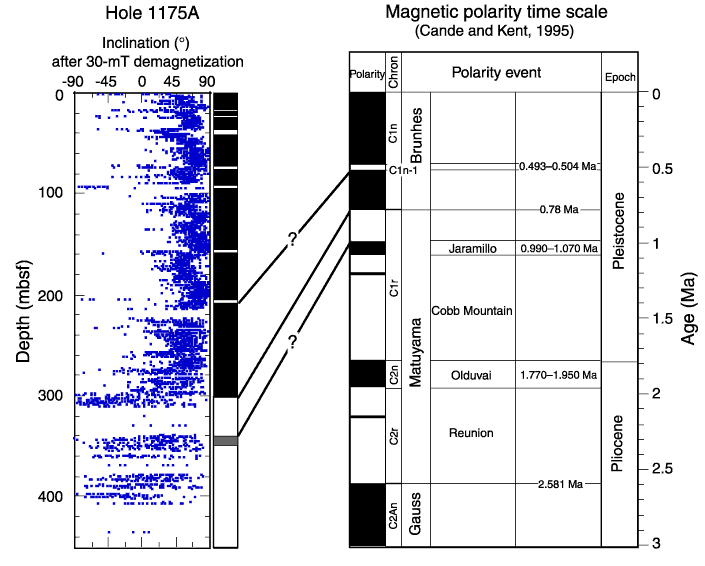
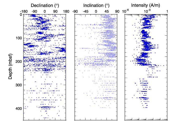
Unfortunately declination isn't very useful. I saw in a post today (April 18 ) that Jose linked to a flash movie showing changes in declination over the last "few centuries." You can see from that animation that declination is pretty variable, so it can't be used to infer much. Inclination is more useful in two ways - it's got a magnitude, and it's got a polarity. The magnitude can be used to calculate latitude (inclination is 0 at the equator and 90 degrees at the poles), and the polarity can be used to calculate whether the magnetic field at the time a rock formed was normal or reversed. That's important for the question about inclination you asked - tilting the upper portion of the figure (from 0-300 m) relative to the lower (300-400 m) will change the magnitude of the inclination, but not the polarity. That means that if you were to use the inclination to calculate the latitude the samples formed at you'd be wrong since the magnitude of the inclination has been changed, but the polarity is the same - magnetic north in the sample would still be magnetic north in the layers of the rock that have normal polarity and reversed in the layers of the rock with reversed polarity. I should have made that distinction earlier. Here's a version of the graph I linked to with the periods of normal and reversed polarity (and a rough attempt to correlate those with the global polarity scale):otseng wrote:From the data in the declination graph, it would appear that sediments randomly points to different magnetic directions. Shouldn't it have some clear pattern to it? Also, couldn't the pattern in the inclination be interpreted that the top portion was simply displaced at an angle?
Post #124
You didn't say it, but I want to point out that the observation that the magnetic field intensity has been decreasing since the 1830's doesn't mean it's been decreasing for all of Earth's history. Besides measuring magnetic declination and inclination in rocks it's also possible to measure magnetic intensity. Here's a graph of the intensity over the last 4 Ma:otseng wrote:What we do know about the earth's magnetic field is that its intensity has been decreasing. Ever since the 1830's, we know through direct measurement of the magnetic field that the intensity of the field has decreased about 10%. Or annualized, that means it has been decreasing at around 0.07 percent per year. A decreasing intensity does not necessarily lead to a complete polarity reversal. If I hook up an electromagnet to a battery, the magnetic field will decrease over time. But, that does not mean it is necessarily oscillating.

These are very interesting questions. Unfortunately I can't add much to what others have said - the mechanism(s) that control changes in polarity aren't perfectly known but the observations that polarity reversals occur is very clear.otseng wrote: A complete polarity reversal would present many questions. Where is the energy coming from to increase the magnetic field? Why is it oscillating? Has the magnetic field intensity ever been zero? Would not magnetic polarity reversals screw up migratory animals? How can they adapt to such changes?

-
otseng

- Savant
- Posts: 20984
- Joined: Thu Jan 15, 2004 1:16 pm
- Location: Atlanta, GA
- Has thanked: 218 times
- Been thanked: 393 times
- Contact:
Post #126
ST88 wrote:
Mantle convection also depends on the structure of the material. One major difference is that the oatmeal convection happens in a closed concave vessel. Mantle convection happens in a continuous convex vessel (so convex as to be spherical-ish).
Still, how can a concave mantle shape produce a non-random convection with periods of millions of years?
I'm also curious if anyone can produce a diagram showing how mantle convections are operating on a global scale. All the diagrams I've seen are a cross-sectional illustration just to give the concept. But I have not seen a global top-view model to illustrate the convection cycles relative to all the convergent and divergent boundaries.
Project "Paleonuclides" and Related Activities
The Role of Electromagnetic Energy in the Regulation of Life Processes
Certainly interesting hypotheses, but they are only that. They cannot be offered as evidence for a reversal in magnetic polarity.
Jose wrote:
The USGS Geomagnetism Program has some information that I've found useful here.
I perused a site a bit. And all I can say is that we can make entire careers out of a single subtopic that has been introduced in this thread (palaeomagnetism, geomagnetism, magnetostratigraphy, etc).
The declination animated image is certainly interesting. Though I'm not sure if there is enough there for us to go on to make any generalizations about polarity reversals. We do see magnetic north and south moving, but they generally are in a certain area. If we saw something like a magnetic pole moving across the equator, that would be strong evidence. Of course, it could just be that we haven't been looking long enough. But, that is all the data that we have so far.
John S wrote:
Unfortunately declination isn't very useful. I saw in a post today (April 18 ) that Jose linked to a flash movie showing changes in declination over the last "few centuries." You can see from that animation that declination is pretty variable, so it can't be used to infer much. Inclination is more useful in two ways - it's got a magnitude, and it's got a polarity.
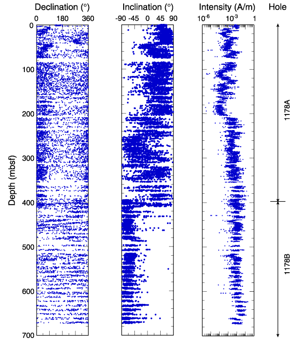
I would like to explore this idea further. If rocks are somehow able to "capture" magnetic fields during their formation, I would expect declination information to be captured as well. I would expect that the only difference between inclination and declination is that one captures the vertical angle and the other the horizontal angle of magnetic north. These two sets of data should correlate with each other. I looked at the IODP site and tried to find some sediment samples. And I found some here, here, and here. These samples further show that declination is random.
Also, out of curiosity, were you able to find a global diagram of magnetic anomalies?
Post #127
You asked this before, and I don't know if I'm understanding exactly what you're asking. Are you asking why this river of rock around the mantle doesn't run faster than it appears to? If so, there's a tremendous amount of gravitational pressure at the depths of the mantle, and the movement is not exactly analogous to volcanic lava, it's more like the liquidity of glass. I think the technical name for it is "plastic." It's amazing to think that anything can move at all.otseng wrote:ST88 wrote:
Mantle convection also depends on the structure of the material. One major difference is that the oatmeal convection happens in a closed concave vessel. Mantle convection happens in a continuous convex vessel (so convex as to be spherical-ish).
Still, how can a concave mantle shape produce a non-random convection with periods of millions of years?
The speed of the core's independent spin is between 0.4 and 1.8 degrees a year which works out to a full lap relative to a fixed point on the surface about every 400 years. The leading suggestion for the cause of the independent motion is an interaction between magnetic fields generated by fluids moving in the Earth's outer core which is molten iron and the inner, solid crystal. The implications of differential rotation between the core and the surface are hot topics at professional meetings and in various physical and geophysical journals. The iron crystal in the core is longer from north to south, but it does not exactly match Earth's poles. As a result of the core's orientation and rotation, "magnetic north" moves over time. The physical pole of the planet also wobbles over time, a process called the "precession of the equinoxes."
-- Historical Geology - Part III - Plate Tectonics -- Introduction
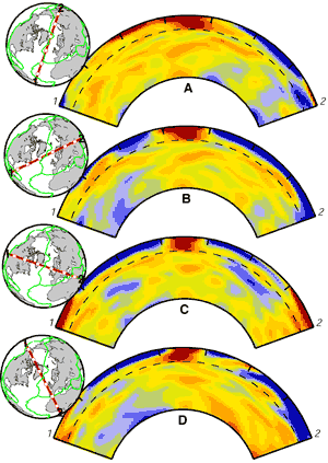
I'm not sure if this is what you asked for, but this is an interesting representation:otseng wrote:I'm also curious if anyone can produce a diagram showing how mantle convections are operating on a global scale. All the diagrams I've seen are a cross-sectional illustration just to give the concept. But I have not seen a global top-view model to illustrate the convection cycles relative to all the convergent and divergent boundaries.

Maybe someone else could help with the interpretation of this graphic.In this view from the southwest the red blobs are warmer plumes of less dense material, rising principally into the ocean-ridge spreading centers. A huge plume seems to be feeding spreading at the East Pacific Rise directly from the core. Most of the heat being released from the earth's interior emerges at the fast-spreading East Pacific Rise.
-- Earth's Interior
There are some interesting discussions here:
http://www.seismology.harvard.edu/data/
This level of scientific talk is well beyond me, but there's some pretty pictures.
http://www.seismology.harvard.edu/proje ... /S20A.html
-
otseng
- Savant
- Posts: 20984
- Joined: Thu Jan 15, 2004 1:16 pm
- Location: Atlanta, GA
- Has thanked: 218 times
- Been thanked: 393 times
- Contact:
Post #128
ST88 wrote:
You asked this before, and I don't know if I'm understanding exactly what you're asking.
I'll try to clarify my thoughts.

Plate tectonics says that plates move because of mantle convection. Plates are supposed to have moved for large distances and in a fairly straight path. For example, we see the Americas moved west from the oceanic ridge and Europe/Africa moved east from the ridge. And if hotspot theory is correct, we further see that plates move in a fairly straight path (except for the bending).

So, these plates movements are not random. That is, they are not moving east for a few hundred years, then southwest for a thousand years, then north for a decade, then south for a few thousand years. They have moved in a singular direction for millions of years. Even looking at this animation shows that convection cycles must be in place for millions of years to move the continents apart. The continents are moving apart and not randomly wandering.

If convection cycles were random, we should see the plates also moving randomly. But, the evidence shows that the plates have not been moving randomly.
As Jose stated earlier:
Jose wrote:By analogy, I think of a pot of water being heated. If it's in a glass vessel, like a beaker, then we can see the convection currents from the schlieren lines (little lines from changes in refractive index of the water, resulting from different densities of hot and cold water). The currents do a general up-here-then-down-there kind of motion, but the location and direction of the currents can change. It's pretty much a chaotic system, with no hard and fast rules about where the currents have to form.
So, by this do I say there is a discrepancy. In our observations of boiling pots of water, the convection cycles are random. But, in the mantle convection, the cycles are not random, but occur in a fixed place for millions of years.
It's amazing to think that anything can move at all.
I would definitely agree with this.
I'm not sure if this is what you asked for, but this is an interesting representation:
Close. I'm looking for a mantle convection diagram like the first one I presented above, but for the entire globe.
Post #129
I really like these questions. I normally don't worry about magnetic declination because it's not useful for the applications of paleomagnetism I'm familiar with. As I've mentioned before, in paleomagnetic studies the paleolatitude and not the paleolongitude is reported. This is because the paleolatitude can be constrained using inclination, but the paleolongitude can't (as I've phrased it before, declination isn't usually useful). You're right that declination as well as inclination is recorded as a rock forms, but there's a reason that declination isn't very useful in calculating paleolongitude. I'm going to start by showing how inclination is useful. Inclination is a vertical angle, therefore if you tilt a rock after it's formed, you'll change the measured inclination. For example, if a rock forms with an inclination of 30 degrees, and then it's tilted in that same direction 15 degrees sometime after that, the measured inclination would be 45 degrees. If you use the inclination of 45 degrees to calculate the latitude the rock formed at you'll get the wrong answer. That's a problem, but it's easy to correct for. Sedimentary rocks are originally deposited horizontally, so if the present bedding isn't horizontal, you know that rocks were tilted after they were deposited. You can recognize, and subtract, that tilt from the measured inclination to correct for the tilt.otseng wrote: I would like to explore this idea further. If rocks are somehow able to "capture" magnetic fields during their formation, I would expect declination information to be captured as well. I would expect that the only difference between inclination and declination is that one captures the vertical angle and the other the horizontal angle of magnetic north. These two sets of data should correlate with each other. I looked at the IODP site and tried to find some sediment samples. And I found some here, here, and here. These samples further show that declination is random.
Declination is a horizontal angle, so it'll be effected by rotation around a vertical axis (like a record spinning). If a rock forms with a declination of 60 degrees, and sometime after that is rotated 20 degrees counterclockwise, the measured declination would be 40 degrees. If you use this to calculate the paleolongitude you'll get the wrong answer, and there's no way to correct for any rotations that occurred after a rock formed. There's no "marker" like there is with inclination. You can rotate a bed to horizontal to correct the measured inclination, but that bed could have been rotated about a vertical axis, and there's no way to tell if it was or not. That's why declination isn't very useful (or at least not nearly as useful as inclination). It is recorded along with inclination when a rock forms, but it can't be constrained like inclination can.
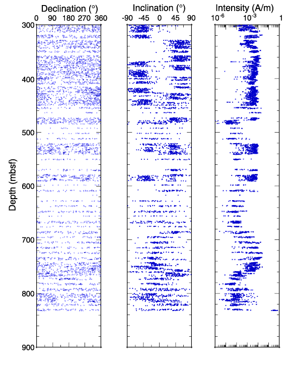
So that's why I don't usually worry about declination. It turns out that's also the reason for the scatter in the IODP data. Prompted by your questions I took a look at the descriptions of the sites that the figures you linked to were from: Site 1176, Site 1177, and Site 1178 from ODP Leg 190. In the "Paleomagnetism" section of those reports it says that the reason that the declinations are scattered is that the cores the were collected rotated during drilling. Cores are collected in what's basically a hollow pipe- once they're in that pipe they can rotate, and if they do that'll mess up the declination. The problem will be especially bad in areas of poor recovery, where only small, discontinuous, samples are returned - each of those samples can rotate in the core barrel. These rotations are around a vertical axis (since the holes are vertical) so they won't mess up the inclination, but they will mess up the declination. If the core can be oriented, if the rotation within the core barrel can be accounted for, then this problem goes away. The core from the upper part of Site 1176 was oriented, and you'll see that the declination there isn't random. So, if you can account for rotation of the core within the core barrel then you can get meaningful information from the declination. If you can't then declination isn't good for much.
I haven't found the map I'm thinking of, but I did find something close. I found some maps in a text book that I have, but they can't really be scanned because they're on two pages - all of the data in the gutter of the book wouldn't scan. I found the original reference, and I'll try to scan some of the maps next week. They're not the same sort as the images of the ridge in Cascadia and the ridge off Iceland that have been linked to, but they do have the magnetic anomalies marked. If you're inclined to track the maps down before I get around to scanning them the reference is: OWEN H.G., 1983. Atlas of Continental Displacement, 200 Million Years to the Present. Cambridge Earth Series, Cambridge University Press, Cambridge.otseng& wrote: Also, out of curiosity, were you able to find a global diagram of magnetic anomalies?
Post #130
A few thoughts on mantle convection.
1) The mantle is really thick - it extends from ~12-70 km to almost 2900 km. So the cells are big, and the material has a long way to travel. Plate velocities are on the order of a few centimeters a year. Couple that with cells that are almost 3000 kilometers tall, and that's pretty slow. Speed it up by 10 or 100 times and that's still pretty slow. Why is it slow?
2) The viscosity of the mantle is really high. The viscosity of the upper mantle is 10^19 to 10^21 Pascal seconds - for comparison the viscosity of water is 10^-3 PaS. That means that the mantle is at least 10^23 times more viscous than water. Something that viscous isn't going to move very quickly. I tried to find a good explanation of the reasoning behind these calculations online - the best I can do is here. It's the final two paragraphs before the bibliography.
3) The mantle isn't molten (except in a small number of areas). In other words the mantle is usually solid. How do we know this? There are two types of seismic waves; P-waves (compressional waves) and S-waves (shear waves). P-waves travel through solids and liquids, S-waves only travel through solids. S-waves travel through the mantle, therefore the mantle isn't liquid. The only region of the interior of the earth that is liquid is the outer core.
The point I'm trying to make? The mantle is hot, dense, generally solid, slow moving, really viscous rock.
Have mantle convection cells been imaged? Yes. Using a technique called siesmic tomography it's possible to figure out where areas that are slower than average (hotter) (shown in red on most tomographic images) and faster than average (colder) (shown in blue) in the mantle. Here's a tomographic image of a subducting slab (i.e., downwelling cold material):

Here are images of a hot upwelling under Iceland (the images stop at the core-mantle boundary at ~2900 km depth):
Edited on April 24 to correct misstatement about S-waves.
1) The mantle is really thick - it extends from ~12-70 km to almost 2900 km. So the cells are big, and the material has a long way to travel. Plate velocities are on the order of a few centimeters a year. Couple that with cells that are almost 3000 kilometers tall, and that's pretty slow. Speed it up by 10 or 100 times and that's still pretty slow. Why is it slow?
2) The viscosity of the mantle is really high. The viscosity of the upper mantle is 10^19 to 10^21 Pascal seconds - for comparison the viscosity of water is 10^-3 PaS. That means that the mantle is at least 10^23 times more viscous than water. Something that viscous isn't going to move very quickly. I tried to find a good explanation of the reasoning behind these calculations online - the best I can do is here. It's the final two paragraphs before the bibliography.
3) The mantle isn't molten (except in a small number of areas). In other words the mantle is usually solid. How do we know this? There are two types of seismic waves; P-waves (compressional waves) and S-waves (shear waves). P-waves travel through solids and liquids, S-waves only travel through solids. S-waves travel through the mantle, therefore the mantle isn't liquid. The only region of the interior of the earth that is liquid is the outer core.
The point I'm trying to make? The mantle is hot, dense, generally solid, slow moving, really viscous rock.
Have mantle convection cells been imaged? Yes. Using a technique called siesmic tomography it's possible to figure out where areas that are slower than average (hotter) (shown in red on most tomographic images) and faster than average (colder) (shown in blue) in the mantle. Here's a tomographic image of a subducting slab (i.e., downwelling cold material):
Here are images of a hot upwelling under Iceland (the images stop at the core-mantle boundary at ~2900 km depth):
Edited on April 24 to correct misstatement about S-waves.
Last edited by John S on Sun Apr 24, 2005 10:41 am, edited 1 time in total.
